Tatoosh Island, Washington
48°23′31″N 124°44′10″W / 48.39208°N 124.73618°W / 48.39208; -124.73618
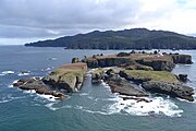
Tatoosh Island

Cape Flattery Light from offshore


Tatoosh Island is a small island and small group of islands about 0.5 miles (0.8 km) offshore (northwest) of Cape Flattery, which is on the northwestern tip of the Olympic Peninsula in Washington. Tatoosh is the largest of a small group of islands also often referred to as simply "Tatoosh Island", which are almost as far west as Cape Alava, which is about 15 miles (24 km) to the south and the westernmost point in the contiguous 48 states. The islands are part of the Makah Reservation and a part of Clallam County. The total land area of the island group is 159,807 square metres (1,720,150 square feet).
History
Historically, Tatoosh Island was inhabited seasonally by Makah fishing camps and employees of the United States Coast Guard, Weather Bureau, and Navy. Currently, there is no resident population on the islands. Access to the island requires written permission of the Makah tribe. The island's name comes from a Makah chief known as Tatoosh[2] (also Tatooche or Tetacus).
Tatoosh Island has been home to Cape Flattery Light, which overlooks the entrance to the Strait of Juan de Fuca, since December 28, 1857.[3]
The whole island was added to the National Register of Historic Places in 1972.[4]
Ecology
Because of its isolation, climate, and location in the ecologically productive northeastern Pacific Ocean, Tatoosh Island is home to many nesting seabirds, several marine mammals, and a diverse community of marine plants and animals. Beginning in 1967, Professor Robert T. Paine of the University of Washington and his colleagues have undertaken detailed studies of marine ecology on the island. In 1990, Julia Parrish came to the island after an invitation from one of Paine's students and began a long-term research study of sea birds on the island.[5]
The research has revealed how species are linked to each other through a network of species interactions, and how environmental changes and species extinction are transmitted through the food web. Key ecological concepts explored by this research include keystone species, control by consumers and natural disturbances on ecosystem structure and spatial patterning, species interaction strength, body size-dependent population dynamics, and impacts of environmental changes such as ocean acidification and El Niño events on complex ecosystems.
Climate
Tatoosh Island has an extremely moderated oceanic climate (Köppen Cfb) with very cool but quite long summers, and long, moderate and wet winters. The climate is much more similar to northern Scotland or Haida Gwaii than western Washington. This is due to its exposed location for maritime winds that temper both heat and cold extremes year-round and eliminate dry summers typical of the western/west-southwestern coast of North America. Because of its exposed northwestern location compared to the rest of the state, it is in hardiness zone 9b (25.0 to 30.0 °F (−3.9 to −1.1 °C) mean minimum temp.) as opposed to between 7b and 9a for most of the rest of western Washington.[6]
| Climate data for Tatoosh, Washington | |||||||||||||
|---|---|---|---|---|---|---|---|---|---|---|---|---|---|
| Month | Jan | Feb | Mar | Apr | May | Jun | Jul | Aug | Sep | Oct | Nov | Dec | Year |
| Record high °F (°C) | 64 (18) | 64 (18) | 67 (19) | 75 (24) | 81 (27) | 82 (28) | 80 (27) | 78 (26) | 80 (27) | 77 (25) | 68 (20) | 61 (16) | 82 (28) |
| Mean daily maximum °F (°C) | 45.3 (7.4) | 46.8 (8.2) | 48.0 (8.9) | 51.5 (10.8) | 55.0 (12.8) | 57.7 (14.3) | 59.5 (15.3) | 59.8 (15.4) | 59.1 (15.1) | 55.8 (13.2) | 50.7 (10.4) | 47.5 (8.6) | 53.1 (11.7) |
| Daily mean °F (°C) | 42.0 (5.6) | 43.2 (6.2) | 44.1 (6.7) | 47.3 (8.5) | 50.8 (10.4) | 53.7 (12.1) | 55.5 (13.1) | 55.8 (13.2) | 54.7 (12.6) | 51.9 (11.1) | 47.2 (8.4) | 44.2 (6.8) | 49.2 (9.6) |
| Mean daily minimum °F (°C) | 38.7 (3.7) | 39.6 (4.2) | 40.2 (4.6) | 43.2 (6.2) | 46.7 (8.2) | 49.8 (9.9) | 51.5 (10.8) | 51.8 (11.0) | 50.3 (10.2) | 48.0 (8.9) | 43.6 (6.4) | 40.9 (4.9) | 45.4 (7.4) |
| Record low °F (°C) | 14 (−10) | 20 (−7) | 25 (−4) | 33 (1) | 37 (3) | 43 (6) | 45 (7) | 45 (7) | 43 (6) | 33 (1) | 19 (−7) | 14 (−10) | 14 (−10) |
| Average precipitation inches (mm) | 10.58 (269) | 8.91 (226) | 8.12 (206) | 5.28 (134) | 2.96 (75) | 2.71 (69) | 2.29 (58) | 2.06 (52) | 3.49 (89) | 8.34 (212) | 10.69 (272) | 12.15 (309) | 77.55 (1,970) |
| Average snowfall inches (cm) | 3.5 (8.9) | 1.6 (4.1) | 1.7 (4.3) | 0 (0) | 0 (0) | 0 (0) | 0 (0) | 0 (0) | 0 (0) | 0 (0) | 0.4 (1.0) | 1.6 (4.1) | 8.8 (22) |
| Average precipitation days (≥ 0.01 in) | 22 | 19 | 20 | 17 | 13 | 13 | 11 | 12 | 11 | 17 | 21 | 24 | 199 |
| Source: WRCC (normals 1931-1966)[7] | |||||||||||||
Gallery
-
 Cape Flattery Lightstation, circa 1943 - 1953
 -


References
- ^ "National Register Information System". National Register of Historic Places. National Park Service. July 9, 2010.
- ^ Elyea, Winifred. 1929. "History of Tatoosh Island" Washington Historical Quarterly, 1929, Vol. 20, No. 3, p. 223-227, Washington University State Historical Society, archived from the original on June 16, 2013, retrieved April 9, 2013
- ^ Cape Flattery Light on Tatoosh Island begins operating on December 28, 1857, HistoryLink.org
- ^ "Nomination Form for Tatoosh Island". National Park Service. and accompanying pictures
- ^ Wagner, Eric (June 14, 2010). "The Value of Dead Bird Watching". Pacific Standard. Retrieved October 6, 2021.
- ^ "2023 USDA Plant Hardiness Zone Map | USDA Plant Hardiness Zone Map". planthardiness.ars.usda.gov. Retrieved February 5, 2024.
- ^ "General Climate Summary Tables". Western Regional Climate Center. Retrieved November 25, 2012.
- Tatoosh Island group: Blocks 2046 and 2047, Census Tract 9801, Clallam County, Washington United States Census Bureau
- Paine, R. T. 1994. Marine Rocky Shores and Community Ecology: An Experimentalist's Perspective. Ecology Institute, Oldendorf/Luhe, Germany.
External links
Wikimedia Commons has media related to Tatoosh Island.
- Photos and other items about Tatoosh Island from the Library of Congress
- History of Tatoosh Island from the University of Washington Libraries Digital Collections website
- Station TTIW1 - Tatoosh Island, WA from the National Data Buoy Center of the NOAA, with "sector pictures"
- Maps including Tatoosh Island, from the official Makah website
- Cape Flattery Tribal Scenic Byway from the Washington State Tourism website
- Photos of Cape Flattery Lighthouse and Helipad, from a commercial photographer's website
- Cape Flattery Lighthouse
- University of Washington Libraries Digital Collections – Makah Cultural and Research Center Online Museum Exhibit History and culture of the Makah tribe; includes images from Tatoosh Island.
- Research summaries, scientific articles, photographs of Tatoosh Island and its organisms, and a video interview of ecologists Cathy Pfister and Tim Wootton
- v
- t
- e
- Admiralty Head Light
- Alki Point Light
- Browns Point Light
- Burrows Island Light
- Cape Disappointment Light
- Cape Flattery Light
- Cattle Point Light
- Clover Island Light
- Destruction Island Light
- Dofflemyer Point Light
- Ediz Hook Light
- Grays Harbor Light
- Lime Kiln Light
- Marrowstone Point Light
- Mukilteo Light
- New Dungeness Light
- North Head Light
- Patos Island Light
- Point No Point Light
- Point Roberts Light
- Point Robinson Light
- Point Wilson Light
- Semiahmoo Harbor Light
- Slip Point Light
- Smith Island Light
- Turn Point Light
- West Point Light
- Willapa Bay Light

National Register of Historic Places listings in Washington (state) | ||
|---|---|---|
| Lists by county |
|  |
| Other lists |
| |


Authority control databases | |
|---|---|
| International |
|
| National |
|


