National Register of Historic Places listings in Okanogan County, Washington

This list presents the full set of buildings, structures, objects, sites, or districts designated on the National Register of Historic Places in Okanogan County, Washington, and offers brief descriptive information about each of them. The National Register recognizes places of national, state, or local historic significance across the United States.[1] Out of over 90,000 National Register sites nationwide,[2] Washington is home to approximately 1,500,[3] and 17 of those are found in Okanogan County.
This National Park Service list is complete through NPS recent listings posted May 31, 2024.[4]
Current listings
| [5] | Name on the Register | Image | Date listed[6] | Location | City or town | Description |
|---|---|---|---|---|---|---|
| 1 | Bonaparte Mountain Cabin | Upload image | April 20, 1981 (#81000588) | E of Tonasket in Okanogan National Forest 48°47′06″N 119°07′17″W / 48.785°N 119.121389°W / 48.785; -119.121389 (Bonaparte Mountain Cabin) | Tonasket | |
| 2 | Chief Joseph Memorial |  | May 15, 1974 (#74001970) | Near jct. of WA 10A and Cache Creek Rd. 48°10′08″N 118°58′34″W / 48.168889°N 118.976111°W / 48.168889; -118.976111 (Chief Joseph Memorial) | Nespelem | |
| 3 | Columbia River Bridge at Bridgeport | 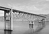 | May 31, 1995 (#95000632) | WA 17 over the Columbia R. 48°00′04″N 119°39′13″W / 48.001111°N 119.653611°W / 48.001111; -119.653611 (Columbia River Bridge at Bridgeport) | Bridgeport | |
| 4 | Early Winters Ranger Station Work Center |  | April 11, 1986 (#86000841) | Okanogan National Forest 48°35′41″N 120°25′48″W / 48.594722°N 120.43°W / 48.594722; -120.43 (Early Winters Ranger Station Work Center) | Winthrop | |
| 5 | Enloe Dam and Powerplant |  | October 18, 1978 (#78002764) | 4 mi (6.4 km). (6.4 km) W of Oroville 48°57′57″N 119°30′03″W / 48.965833°N 119.500833°W / 48.965833; -119.500833 (Enloe Dam and Powerplant) | Oroville | |
| 6 | Sites of Fort Okanogan |  | June 4, 1973 (#73001883) | N of Bridgeport between the Columbia and Okanogan Rivers 48°05′59″N 119°43′06″W / 48.099722°N 119.718333°W / 48.099722; -119.718333 (Sites of Fort Okanogan) | Bridgeport | |
| 7 | Fort Okanogan Interpretive Center |  | August 17, 2018 (#100002814) | 14379 US 17 48°05′53″N 119°40′42″W / 48.0980°N 119.6784°W / 48.0980; -119.6784 (Fort Okanogan Interpretive Center) | Brewster | |
| 8 | Grand Coulee Bridge | 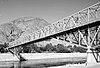 | July 16, 1982 (#82004267) | Spans Columbia River 47°57′56″N 118°58′53″W / 47.965556°N 118.981389°W / 47.965556; -118.981389 (Grand Coulee Bridge) | Grand Coulee | Historic Bridges and Tunnels in Washington TR |
| 9 | Lost Lake Guard Station |  | April 11, 1986 (#86000814) | Okanogan National Forest 48°50′42″N 119°02′54″W / 48.845°N 119.048333°W / 48.845; -119.048333 (Lost Lake Guard Station) | Tonasket | |
| 10 | Okanogan County Courthouse | 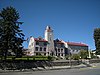 | June 29, 1995 (#95000805) | 149 N. Third Ave. 48°21′55″N 119°34′49″W / 48.365278°N 119.580278°W / 48.365278; -119.580278 (Okanogan County Courthouse) | Okanogan | |
| 11 | Okanogan Project: Conconully Reservoir Dam |  | September 6, 1974 (#74001969) | S of Conconully 48°32′16″N 119°44′53″W / 48.537778°N 119.748056°W / 48.537778; -119.748056 (Okanogan Project: Conconully Reservoir Dam) | Conconully | |
| 12 | Parson Smith Tree | 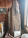 | March 16, 1972 (#72001279) | 24 W Chewuch Rd 48°28′44″N 120°11′22″W / 48.4789302°N 120.189367°W / 48.4789302; -120.189367 (Parson Smith Tree) | Winthrop | Formerly 40 mi (64 km). N of Winthrop on the Canada–US border in Okanogan National Forest, now in the lobby of the Methow Valley Ranger Station. |
| 13 | Saint Mary's Mission | Upload image | December 20, 2018 (#100002609) | Address Restricted | Omak vicinity | |
| 14 | Hiram F. Smith Orchard | Upload image | November 12, 1975 (#75001863) | 2 mi (3.2 km). N of Oroville on Osoyoos Lake 48°58′00″N 119°25′42″W / 48.966667°N 119.428333°W / 48.966667; -119.428333 (Hiram F. Smith Orchard) | Oroville | |
| 15 | U.S. Post Office – Okanogan Main |  | May 30, 1991 (#91000650) | 212 Second Ave. N. 48°21′53″N 119°34′41″W / 48.364722°N 119.578056°W / 48.364722; -119.578056 (U.S. Post Office – Okanogan Main) | Okanogan | |
| 16 | U.S. Post Office – Omak Main |  | May 30, 1991 (#91000651) | 104 S. Main St. 48°24′34″N 119°31′40″W / 48.409444°N 119.527778°W / 48.409444; -119.527778 (U.S. Post Office – Omak Main) | Omak | |
| 17 | Guy Waring Cabin |  | March 19, 1982 (#82004268) | 285 Castle Ave. 48°28′36″N 120°10′50″W / 48.476667°N 120.180556°W / 48.476667; -120.180556 (Guy Waring Cabin) | Winthrop |
See also
- National Register of Historic Places listings in Washington state
- Listings in neighboring counties: Chelan, Douglas, Ferry, Grant, Lincoln, Skagit, Whatcom
- Historic preservation
- History of Washington (state)
- Index of Washington (state)-related articles
References
- ^ Andrus, Patrick W.; Shrimpton, Rebecca H.; et al. (2002). "How to Apply the National Register Criteria for Evaluation". National Register Bulletin. National Park Service, U.S. Department of the Interior. Retrieved June 20, 2014.
- ^ National Park Service. "National Register of Historic Places Program: Research". Retrieved January 28, 2015.
- ^ Department of Archaeology and Historic Preservation. "Washington Information System for Architectural and Archaeological Records Data (WISAARD)". Retrieved February 14, 2015.
- ^ National Park Service, United States Department of the Interior, "National Register of Historic Places: Weekly List Actions", retrieved May 31, 2024.
- ^ Numbers represent an alphabetical ordering by significant words. Various colorings, defined here, differentiate National Historic Landmarks and historic districts from other NRHP buildings, structures, sites or objects.
- ^ The eight-digit number below each date is the number assigned to each location in the National Register Information System database, which can be viewed by clicking the number.
External links
Map all coordinates using OpenStreetMap
Download coordinates as:
- KML
- GPX (all coordinates)
- GPX (primary coordinates)
- GPX (secondary coordinates)
- Washington Department of Archaeology and Historic Preservation, Historic Register program
- National Park Service, National Register of Historic Places site
 Media related to National Register of Historic Places in Okanogan County, Washington at Wikimedia Commons
- v
- t
- e
National Register of Historic Places listings in Washington (state)
by county
- Adams
- Asotin
- Benton
- Chelan
- Clallam
- Clark
- Columbia
- Cowlitz
- Douglas
- Ferry
- Franklin
- Garfield
- Grant
- Grays Harbor
- Island
- Jefferson
- King
- Kitsap
- Kittitas
- Lewis
- Lincoln
- Mason
- Okanogan
- Pacific
- Pend Oreille
- Pierce
- San Juan
- Skagit
- Skamania
- Snohomish
- Spokane
- Stevens
- Thurston
- Wahkiakum
- Walla Walla
- Whatcom
- Whitman
- Yakima

- National Historic Landmarks
- Bridges and Tunnels
| |
|---|---|
| Topics | |
| Lists by state |
|
| Lists by insular areas | |
| Lists by associated state | |
| Other areas | |
| Related | |
| |


Municipalities and communities of Okanogan County, Washington, United States | ||
|---|---|---|
County seat: Okanogan | ||
| Cities |  | |
| Towns | ||
| CDPs | ||
| Unincorporated communities | ||
| Indian reservation | ||
| Ghost towns | ||
| Footnotes | ‡This populated place also has portions in an adjacent county or counties | |
| ||


