National Register of Historic Places listings in Mason County, Washington

This list presents the full set of buildings, structures, objects, sites, or districts designated on the National Register of Historic Places in Mason County, Washington, and offers brief descriptive information about each of them. The National Register recognizes places of national, state, or local historic significance across the United States.[1] Out of over 90,000 National Register sites nationwide,[2] Washington is home to approximately 1,500,[3] and 18 of those are found in Mason County.
This National Park Service list is complete through NPS recent listings posted May 10, 2024.[4]
Current listings
| [5] | Name on the Register | Image | Date listed[6] | Location | City or town | Description |
|---|---|---|---|---|---|---|
| 1 | Big Creek Archeological Site-45MS100 | Upload image | October 13, 1999 (#99001219) | Address Restricted | Hoodsport | |
| 2 | Cushman Hydroelectric Project Historic District |  | February 2, 2015 (#14001244) | 21451 N. U.S. 101 47°22′19″N 123°09′44″W / 47.372020°N 123.162130°W / 47.372020; -123.162130 (Cushman Hydroelectric Project Historic District) | Hoodsport | |
| 3 | Cushman No. 1 Hydroelectric Power Plant |  | December 15, 1988 (#88002759) | South end of Lake Cushman 47°25′23″N 123°13′21″W / 47.423063°N 123.222377°W / 47.423063; -123.222377 (Cushman No. 1 Hydroelectric Power Plant) | Hoodsport | |
| 4 | Cushman No. 2 Hydroelectric Power Plant | 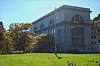 | December 15, 1988 (#88002757) | Skokomish River 47°22′59″N 123°10′42″W / 47.383056°N 123.178333°W / 47.383056; -123.178333 (Cushman No. 2 Hydroelectric Power Plant) | Hoodsport | |
| 5 | Ebenezer Congregational Church |  | September 13, 2018 (#100002940) | 18500 WA 3 47°23′03″N 122°49′43″W / 47.3841°N 122.8287°W / 47.3841; -122.8287 (Ebenezer Congregational Church) | Allyn | |
| 6 | Goldsborough Creek Bridge | 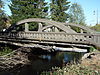 | July 16, 1982 (#82004264) | WA 3 47°12′34″N 123°05′57″W / 47.209444°N 123.099167°W / 47.209444; -123.099167 (Goldsborough Creek Bridge) | Shelton | Historic Bridges and Tunnels in Washington TR |
| 7 | Harstine Island Community Hall |  | March 16, 1989 (#89000212) | North Island Dr. and Hartstene Island Dr. 47°16′35″N 122°53′10″W / 47.276389°N 122.886111°W / 47.276389; -122.886111 (Harstine Island Community Hall) | Harstine Island | |
| 8 | High Steel Bridge |  | July 16, 1982 (#82004265) | Spans Skokomish South Fork 47°22′05″N 123°16′44″W / 47.368056°N 123.278889°W / 47.368056; -123.278889 (High Steel Bridge) | Shelton | Historic Bridges and Tunnels in Washington TR |
| 9 | Malaney–O'Neill House | 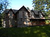 | January 23, 2013 (#12001222) | 1570 E. Agate Bay Road 47°14′49″N 123°00′46″W / 47.246814°N 123.012868°W / 47.246814; -123.012868 (Malaney–O'Neill House) | Shelton vicinity | |
| 10 | Mason County Courthouse |  | January 9, 2013 (#12001160) | 419 N. 4th St. 47°12′57″N 123°06′13″W / 47.215939°N 123.103741°W / 47.215939; -123.103741 (Mason County Courthouse) | Shelton | |
| 11 | North Hamma Hamma River Bridge | 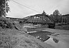 | July 16, 1982 (#82004262) | Spans North Hamma Hamma River 47°32′23″N 123°02′33″W / 47.539722°N 123.0425°W / 47.539722; -123.0425 (North Hamma Hamma River Bridge) | Eldon | Historic Bridges and Tunnels in Washington TR |
| 12 | Shelton Public Library and Town Hall | 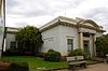 | July 14, 1983 (#83003348) | 5th St. and Railroad Ave. 47°12′48″N 123°06′11″W / 47.213333°N 123.103056°W / 47.213333; -123.103056 (Shelton Public Library and Town Hall) | Shelton | |
| 13 | Schafer State Park |  | May 10, 2010 (#10000255) | 1365 W Schafer Park Rd. 47°05′59″N 123°28′21″W / 47.099614°N 123.472461°W / 47.099614; -123.472461 (Schafer State Park) | Elma | |
| 14 | Simpson Logging Company Locomotive No. 7 and Peninsular Railway Caboose No. 700 |  | January 12, 1984 (#84003532) | 3rd and Railroad Aves. 47°12′47″N 123°06′03″W / 47.213056°N 123.100833°W / 47.213056; -123.100833 (Simpson Logging Company Locomotive No. 7 and Peninsular Railway Caboose No. 700) | Shelton | |
| 15 | South Hamma Hamma River Bridge | 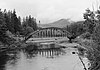 | July 16, 1982 (#82004263) | Spans South Hamma Hamma River 47°32′11″N 123°02′28″W / 47.536389°N 123.041111°W / 47.536389; -123.041111 (South Hamma Hamma River Bridge) | Eldon | Historic Bridges and Tunnels in Washington TR |
| 16 | taba das |  | February 16, 2005 (#05000066) | Address Restricted | Potlatch | |
| 17 | Twanoh State Park |  | September 10, 2014 (#14000614) | 1290 E. WA 106 47°22′27″N 122°58′25″W / 47.3741°N 122.9735°W / 47.3741; -122.9735 (Twanoh State Park) | Union | |
| 18 | Vance Creek Bridge | 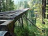 | July 16, 1982 (#82004266) | Northwest of Shelton 47°20′06″N 123°19′10″W / 47.335°N 123.319444°W / 47.335; -123.319444 (Vance Creek Bridge) | Shelton | Historic Bridges and Tunnels in Washington TR |
See also
- National Register of Historic Places listings in Washington state
- Listings in neighboring counties: Grays Harbor, Jefferson, Kitsap, Pierce, Thurston
- Historic preservation
- History of Washington (state)
- Index of Washington (state)-related articles
References
- ^ Andrus, Patrick W.; Shrimpton, Rebecca H.; et al. (2002), How to Apply the National Register Criteria for Evaluation, National Register Bulletin, National Park Service, U.S. Department of the Interior, retrieved June 20, 2014.
- ^ National Park Service, National Register of Historic Places Program: Research, retrieved January 28, 2015.
- ^ Department of Archaeology and Historic Preservation, Washington Information System for Architectural and Archaeological Records Data (WISAARD), retrieved February 14, 2015.
- ^ National Park Service, United States Department of the Interior, "National Register of Historic Places: Weekly List Actions", retrieved May 10, 2024.
- ^ Numbers represent an alphabetical ordering by significant words. Various colorings, defined here, differentiate National Historic Landmarks and historic districts from other NRHP buildings, structures, sites or objects.
- ^ The eight-digit number below each date is the number assigned to each location in the National Register Information System database, which can be viewed by clicking the number.
External links
Map all coordinates using OpenStreetMap
Download coordinates as:
- KML
- GPX (all coordinates)
- GPX (primary coordinates)
- GPX (secondary coordinates)
- Washington Department of Archaeology and Historic Preservation, Historic Register program
- National Park Service, National Register of Historic Places site
 Media related to National Register of Historic Places in Mason County, Washington at Wikimedia Commons
- v
- t
- e
National Register of Historic Places listings in Washington (state)
by county
- Adams
- Asotin
- Benton
- Chelan
- Clallam
- Clark
- Columbia
- Cowlitz
- Douglas
- Ferry
- Franklin
- Garfield
- Grant
- Grays Harbor
- Island
- Jefferson
- King
- Kitsap
- Kittitas
- Lewis
- Lincoln
- Mason
- Okanogan
- Pacific
- Pend Oreille
- Pierce
- San Juan
- Skagit
- Skamania
- Snohomish
- Spokane
- Stevens
- Thurston
- Wahkiakum
- Walla Walla
- Whatcom
- Whitman
- Yakima

- National Historic Landmarks
- Bridges and Tunnels
| |
|---|---|
| Topics | |
| Lists by state |
|
| Lists by insular areas | |
| Lists by associated state | |
| Other areas | |
| Related | |
| |


Municipalities and communities of Mason County, Washington, United States | ||
|---|---|---|
County seat: Shelton | ||
| City |  | |
| CDPs | ||
| Other communities | ||
| Indian reservations | ||
| ||


