Pallipuram Fort
Building in India
 Portugal (1503-1661)
 Netherlands (1661-1789)
 Travancore (1789-1858)
 India
India  Travancore (1858-1947)
 India (1947-)
the public
Pallippuram Fort or (Paleport Castelo em Cima) is a fort in Pallippuram, Vyppin, Ernakulam district of Kerala, south India. It was built by Portuguese sailors on 27 September, 1503 using just timber wood, and later renovated in 1505 by replacing timber structure with stone. It is the oldest existing European fort in India. The Dutch captured the fort in 1663 and sold it to the Kingdom of Travancore in 1789. The fort is situated in the northern extremity of Vypeen island and is hexagonal in shape, a form popularly known as ayikkotta or alikotta.[1]
Structure
Hexagonal in shape, the lowest internal floor of the fort is raised to a height of 5 feet (1.5 m). The gate and the door posts, and the lintels are finely dressed and arched while underground there is a cellar that was used to store gunpowder. A 3.25 by 3.25 feet (0.99 m × 0.99 m) well provided a source of fresh water.
There is an opening to the north which leads to the cellar. There is a circular slab stone, on which was installed a pillar on which the radiating wooden struts supporting the upper two floors must have rested.
Each face of the fort measures 32 feet (9.8 m) long and 34 feet (10 m) high while the walls are six feet thick. Each face of the fort has three embrasures, one above the other. The central opening of the embrasures measures 2 by 2.5 feet (0.61 m × 0.76 m). The fort could have mounted as many as guns commanding all quarters round it. There is an open space inside affording easy passage to the cellar.
The fort is constructed using laterite, chunam, and wood. The walls are thickly plastered using mortar. The door way in the central circular slab is made of granite. All the six sides of the fort are overgrown with vegetation.
It has an underground path which connects to some other openings. It was saying that the route goes under rivers and lands which they used to escape from enemies when needed. The underground path is permanently closed now.
Gallery
-
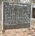 Information board
 -
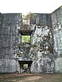 Inner area of ayakotta
 -
 Ruins of the Fort(Wide View)
 -
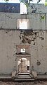 Entrance


References
- ^ "Monuments at a Glance". Government of Kerala. Archived from the original on 22 December 2004. Retrieved 24 February 2014.
External links
Wikimedia Commons has media related to Pallipuram Fort.
- Cochin.org
- Enchantingkerala.org
- Pallippuram Fort on Flickr
- v
- t
- e
- Talatal Ghar
- Kareng Ghar
- Rang Ghar
- Garchuk Lachit Garh
- Anchuthengu
- St. George
- William
- Bombay
- Riwa
- Worli
- Mazagon
- Sion Hillock
- Sewri
- Mahim
- Tellicherry
- St. David
- Ahmednagar
- Daulatabad
- Gawilghur
- Golconda
- Jalna Fort(Mastgarh)
- Narnala
- Panhala
- Bassein Fort
- Bombay Castle
- Mahim
- Arnala
- Castella de Aguada
- Diu Fort
- Surat Castle
- Fortim do Mar, Diu
- Fortim do Mar, Simbor
- Emmanuel
- Fort Anjediva
- Korlai
- Madh Fort
- St Thomas, Tangasseri
- St. Angelo
- Pallipuram
- Aguada
- Fort Tiracol
- Anjediva
- Cranganore
- Ghodbunder
- Fortaleza de Chaul
- Ponda Fort
- Chapora Fort
- Fortaleza de São Sebastião de Tivim
- Cabo de Rama
- Corjuem Fort
- Mormugão fort
- Rachol Fort
- Fort of São Tiago of Banastarim


 | This article related to a location in Ernakulam district, Kerala, India is a stub. You can help Wikipedia by expanding it. |
- v
- t
- e
 | This article about an Indian building or structure is a stub. You can help Wikipedia by expanding it. |
- v
- t
- e


