Siruvani Waterfalls
Waterfall in Tamil nadu, India
10°56′17″N 76°41′14″E / 10.938011°N 76.687177°E / 10.938011; 76.687177Siruvani Waterfalls,[1] and the dam named after them, are located 36 km (22 mi) west of Coimbatore in the Western Ghats. The reservoir at Siruvani was built by the Kerala government for Tamil Nadu, and funded by the Tamil Nadu government, to meet the drinking water requirements of Coimbatore. The gateways on either side of the road across the dam showcase typical Kerala and Tamil architectural styles. Siruvani is also home to certain tribes like the Mudugars and Irulas. The falls and the dam attract tourists for their beautiful views.[1]
History of the dam
The government gave approval for the construction of the masonry gravity dam in February 1915. Work did not start immediately, according to information from the Archaeology Department, Tamil Nadu Water Supply and Drainage (TWAD) Board, and the district gazette. Initially, the villagers of Boluvampatti and Alandurai opposed the scheme, as they feared it would affect their way of life. However, the benefits of additional water to the growing villages outweighed their initial apprehension.
The construction of the dam began in 1927.[2] The site is located in rugged terrain, with hazards including wild animals. Construction workers stayed in the guest house near Iruttu Pallam. Forest guards continue to accompany those who visit the dam. The initial cost of construction was Rs. 2,17,725 for 7 meters (23 feet). The site was selected because it had perennial streams. The areas below the Siruvani, Muthikulam Falls, Gobiyaru, Solaiyaru, Pattiyaru, Veeraru, and Paambaru Falls, the primary sources of supply, were identified for construction.
There were plans to commission a hydroelectric project at Siruvani, but the move was dropped as the Pykara project in the Nilgiris was mooted at the time. Major and minor construction works continued until 1984, and the total cost was Rs. 26.12 crores. The drawn from the dam in 1931 was 113 lakh litres for a population of more than 95,000. In the 1970s, the drawn was scaled down to 130 lakh litres from 186 lakh litres in the summer as inflow into the Muthikulam reduced by half.
Gallery
-
 View of Siruvani falls from path towards falls
 -
 View of all cascades of Siruvani falls above the bathing area
 -
 View of upper cascades above the bathing area
 -
 View of lower cascades above the bathing area
 -
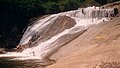 Bathing area below the main cascades of the falls


References
Wikimedia Commons has media related to Siruvani Falls.
- ^ a b "Siruvani Waterfalls". Webindia123. Retrieved 11 July 2020.
- ^ "The Siruvani story". The Hindu. 8 May 2015. ISSN 0971-751X. Retrieved 12 March 2024.
- v
- t
- e
Western Ghats
- Goa
- Gujarat
- Karnataka
- Kerala
- Maharashtra
- Tamil Nadu
- Agasthyamalai
- Ambukuthi
- Anamudi
- Anginda
- Anjaneri
- Baba Budangiri
- Banasura
- Brahmagiri
- Chembra
- Devar Mala
- Devimala
- Dhodap
- Doddabetta
- Don
- Elivai Malai
- Eravimala
- Ettina Bhuja
- Gangamoola
- Gopalaswamy Betta
- Illikkal Kallu
- Kalsubai
- Karimala Gopuram
- Kattumala
- Kemmangudi
- Kodachadri
- Kodikuthi Mala
- Kolaribetta
- Kottamala
- Kudremukh
- Kumara Parvata
- Kumarikkal Mala
- Kurumbalakotta
- Madikeri
- Mahendragiri
- Mahuli
- Malleswaran
- Marunthuvazh Malai
- Meenuliyan Para
- Meesapulimala
- Mukurthi
- Mullayanagiri
- Nedumpara
- Padagiri
- Paithalmala
- Perumal Malai
- Pratapgad
- Purandar
- Raigad
- Rajgad
- Rangaswamy
- Ranipuram
- Ratangad
- Salher
- Saptashrungi
- Saputara
- Sinhagad
- Sispara
- Sonsogor
- Tadiandamol
- Taramati
- Torna
- Vagamon
- Vandaravu
- Varayadumotta
- Vavul Mala
- Velliangiri
- Achankovil
- Adan
- Amarja
- Ambankadavu
- Anjarakandi River
- Arkavathi
- Ayalurpuzha
- Banganga
- Bhadra
- Bhadra
- Bharathappuzha
- Bhavani
- Bhima
- Bindusara
- Chakra
- Chalakudy
- Chalippuzha
- Chaliyar
- Cherukunnapuzha
- Cherupuzha
- Cheruthoni
- Chitravathi
- Chittar
- Chulki Nala
- Chulliyar
- Dahisar
- Daman Ganga
- Dandavati
- Darna
- Edamalayar
- Gangavalli
- Gayathripuzha
- Ghataprabha
- Girna
- Godavari
- Gomai
- Gomukhi
- Gurupura
- Gurupura
- Hemavati
- Honnuhole
- Indravati
- Indrayani
- Iruvanjippuzha
- Ithikkara
- Kabini
- Kadalundi
- Kadva
- Kali
- Kallada
- Kallayi
- Kalpathipuzha
- Kanjirappuzha
- Kannadipuzha
- Karamana
- Karanja
- Karha
- Karimpuzha
- Kaveri
- Kaveri
- Kedaka
- Kodaganar
- Kodavanar
- Kokkiliyar
- Kolar
- Korapuzha
- Korayar
- Kottappuzha
- Koyna
- Koyna
- Krishna
- Krishna
- Kubja
- Kumaradhara
- Kumudvathi
- Kundali
- Kundalika
- Kunthipuzha
- Kurumali
- Kuthirappuzha
- Lakshmana Tirtha
- Madatharuvi
- Mahé
- Malampuzha
- Malaprabha
- Malaprabha
- Mangalam
- Manimala
- Manimuthar
- Manjalar
- Manjira
- Markandeya
- Maruthappuzha
- Meenachil
- Meenkarappuzha
- Mithi
- Moyar
- Mula
- Mula-Mutha
- Mullayar
- Mutha
- Muthirapuzha
- Muvattupuzha
- Nanganjiyar
- Narmada
- Neerppuzha
- Netravati
- Neyyar
- Nira
- Noyyal
- Oshiwara
- Pachaiyar
- Pahrali
- Painganga
- Palar
- Pallichelaru
- Pamba
- Pambar
- Pambar
- Panchagangavalli
- Panchganga
- Pandippuzha
- Panzara
- Papagni
- Papanasini
- Parambikulam
- Patalganga
- Pavana
- Payaswini
- Penna
- Perinjankutti
- Periyar
- Poisar
- Ponnaiyar
- Pranahita
- Punnappuzha
- Purna (Godavari)
- Purna (Tapti)
- Dnyanganga
- Savitri
- Savitri
- Shahanur
- Shambhavi
- Sharavati
- Shimsha
- Shivana
- Sindphana
- Souparnika
- Tansa
- Tapti
- Tasso
- Thamirabarani
- Thuppanadippuzha
- Thuthapuzha
- Tirur
- Tunga
- Tungabhadra
- Ulhas
- Vaan
- Vaippar
- Valapattanam
- Vandazhippuzha
- Varada
- Varahi
- Vashishti
- Vedavathi
- Venna
- Vrishabhavathi
- Wainganga
- Wardha
- Abbey
- Aruvikkuzhy
- Athirappilly
- Ayyanar
- Bandaje
- Barkana
- Catherine
- Charpa
- Chunchanakatte
- Courtallam
- Devaragundi
- Devkund
- Dudhsagar
- Godchinamalaki
- Gokak
- Hanumangundi
- Hebbe
- Hogenakkal
- Irupu
- Irupu
- Jaladurga
- Jog
- Kalhatti (Nilgiris)
- Kalhatti
- Katary
- Kumbakkarai
- Kumbhavurutty
- Kuchikal
- Kune
- Kutladampatti
- Law's
- Magod
- Mallalli
- Manalar
- Meenmutty
- Monkey
- Muthyala Maduvu
- Oliyarik
- Palaruvi
- Pandavgad
- Pattathippara
- Perunthenaruvi
- Sahasrakund
- Sathodi
- Sengupathi
- Shivanasamudra or Cauvery
- Shivanasamudra
- Shivganga
- Siruvani
- Soochipara
- Suruli
- Thalaiyar
- Thusharagiri
- Tirparappu
- Ulakkai
- Unchali
- Unchalli
- Vaideki
- Vajrapoha
- Vattaparai
- Vazhachal
and reserves
- Annekal
- Aralam
- Agasthyamala
- Agasthyavanam
- Bandipur
- Bannerghatta
- Bhadra
- Bhimgad
- Brahmagiri
- Chandoli
- Chimmony
- Chinnar
- Dandeli
- Eravikulam
- Grass Hills
- Grizzled Squirrel
- Kali
- Kalakkad-Mundanthurai
- Karian Shola
- Karnala
- Koyna
- Kudremukh
- Mhadei
- Mudumalai
- Mukurthi
- Nagarhole
- New
- Neyyar
- Nilgiri
- Palani
- Parambikulam
- Peechi-Vazhani
- Peppara
- Periyar
- Pushpagiri
- Radhanagari
- SAI
- Sathyamangalam
- Shendurney
- Silent Valley
- Someshwara
- Talakaveri
- Thanthai
- Wayanad
reservoirs
- Aathupalayam
- Aliyar
- Almatti
- Amaravathi
- Basava Sagara
- Bhadra Dam
- Bhandardara
- Bhatghar
- Bhavanisagar
- Bhushi
- Chaskaman
- Dhom
- Gorur
- Harangi
- Hetwane
- Itiadoh
- Jayakwadi
- Kabini
- Kadra
- Kamarajar Sagar
- Kanher
- Kanva
- Karuppanadhi
- Khadakwasla
- Kodasalli
- Kodiveri
- Kolkewadi
- Koyna
- Krishna Raja Sagar
- Krishnagiri
- Linganamakki
- Manimuthar
- Mettur
- Mukkadal
- Mulshi
- Nallathangal
- Nilwande
- Orathuppalayam
- Panshet
- Papanasam
- Pawna
- Pechiparai
- Perunchani
- Raja Lakhamagouda
- Ramtek
- Renuka Sagara
- Salaulim
- Sathanur
- Servalar
- Shanti Sagara
- Solaiyar
- Supa
- Susri
- Tansa
- Temghar
- Tilari
- Totladoh
- Tungabhadra
- Ujjani
- Upper Bhavani
- Vaigai
- Vaitarna
- Vani Vilasa Sagara
- Varasgaon
- Varattu Pallam
- Veer
- Vihar
- Waghur
- Walwan
- Yeldari
| ||
|---|---|---|
| District headquarters |  | |
| Country | ||
| State | ||
| Region | ||
| Taluks | ||
| Municipal corporations | ||
| Municipalities | ||
| Rivers | ||
| History | ||
| Places of interest |
| |
| Universities | ||
| ||


