Oum El Bouaghi Province
Province of Algeria
Province in Algeria
Oum El Bouaghi Province ولاية أم البواقي | |
|---|---|
Province | |
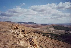 The Hautes Plaines in Oum El Bouaghi | |
 Map of Algeria highlighting Oum El Bouaghi | |
| Coordinates: 35°53′N 7°7′E / 35.883°N 7.117°E / 35.883; 7.117 | |
| Country |  Algeria Algeria |
| Capital | Oum El Bouaghi |
| Government | |
| • PPA president | Mr. Chouia Taha Hocine (FLN) |
| • Wāli | Mr. brimi djamel eddine |
| Area | |
| • Total | 6,768 km2 (2,613 sq mi) |
| Population (2008)[1] | |
| • Total | 644,364 |
| • Density | 95/km2 (250/sq mi) |
| Time zone | UTC+01 (CET) |
| Area Code | +213 (0) 32 |
| ISO 3166 code | DZ-04 |
| Districts | 12 |
| Municipalities | 29 |
Oum El Bouaghi or Oum el-Bouaghi (Arabic: ولاية أم البواقي) is a province (wilaya) of Algeria in the Aures region. The capital is Oum el-Bouaghi, which was named Can Robert (during French occupation), Sidi R'Ghis a few years later, and Oum El Bouaghi before independence.
History
The province was created from Constantine (department) in 1974.
In 1984 Khenchela Province and Mila Province were carved out of its territory.
Administrative divisions
The province is divided into 12 districts (daïras), which are further divided into 29 communes or municipalities.
Districts
Communes
- Aïn Babouche
- Aïn Beïda
- Aïn Diss
- Aïn Fakroun
- Aïn Kercha
- Aïn M'lila
- Aïn Zitoun
- Behir Chergui
- Berriche
- Bir Chouhada
- D'hala (Dhalaâ)
- El Amiria
- El Belala
- El Djazia
- El Fedjouz Boughrara Saoudi
- El Harmilia
- Fkirina (F'Kirina)
- Hanchir Toumghani
- Ksar Sbahi
- Meskiana
- Oued Nini
- Ouled Gacem
- Ouled Hamla
- Ouled Zouaï
- Oum El Bouaghi
- Rahia
- Sigus
- Souk Naâmane
- Zorg
References
 Algeria portal

- ^ Office National des Statistiques, Recensement General de la Population et de l’Habitat 2008 Archived 2008-07-24 at the Wayback Machine Preliminary results of the 2008 population census. Accessed on 2008-07-02.
- v
- t
- e
Oum El Bouaghi ProvinceCapital: Oum El Bouaghi

- Oum el Bouaghi
- Aïn Babouche
- Aïn Beida
- Aïn Diss
- Aïn Fakroun
- Aïn Kercha
- Aïn M'lila
- Aïn Zitoun
- Behir Chergui
- Berriche
- Bir Chouhada
- Dhalaa
- El Amiria
- El Belala
- El Djazia
- El Fedjouz Boughrara Saoudi
- El Harmilia
- Fkirina
- Hanchir Toumghani
- Ksar Sbahi
- Meskiana
- Oued Nini
- Ouled Gacem
- Ouled Hamla
- Ouled Zouaï
- Rahia
- Sigus
- Souk Naamane
- Zorg
| ||
|---|---|---|
|  | |
Authority control databases | |
|---|---|
| International |
|
| National |
|
 | This article about a location in Oum El Bouaghi Province is a stub. You can help Wikipedia by expanding it. |
- v
- t
- e


