Map all coordinates using OpenStreetMap
Download coordinates as:
KML GPX (all coordinates) GPX (primary coordinates) GPX (secondary coordinates) This list includes properties and districts listed on the California Historical Landmark listing in Trinity County, California. Click the "Map of all coordinates" link to the right to view a Google map of all properties and districts with latitude and longitude coordinates in the table below.
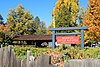
Image [1] Landmark name Location City or town Summary La Grange Mine 778 La Grange Mine State Hwy 299 40°44′28″N 122°59′26″W / 40.741111°N 122.990556°W / 40.741111; -122.990556 (La Grange Mine ) Weaverville Weaverville Joss House 709 Weaverville Joss House Weaverville Joss House State Historic Park 40°43′52″N 122°56′27″W / 40.7311°N 122.9408°W / 40.7311; -122.9408 (Weaverville Joss House ) Weaverville
References ^ "California Historical Landmarks By County". Ohp.parks.ca.gov. Retrieved 2019-04-03 . See also Wikimedia Commons has media related to California Historical Landmarks in Trinity County, California .
National Park System
Parks Preserves Monuments Seashores Historical Parks Historic Sites Memorials Recreation Areas
Parks Natural Reserves Marine Reserves Historic Parks Beaches Recreation Areas Vehicular Other
National Forests and Grasslands
National Forests National Wilderness National Monuments
Wildlife Ecological Marine
National Monuments National California Desert King Range Wilderness Areas