Santa Monica State Beach
State beach in Los Angeles County, California, United States
34°0′54″N 118°30′6″W / 34.01500°N 118.50167°W / 34.01500; -118.50167

Santa Monica State Beach is a California State Park operated by the city of Santa Monica.[1][2]
The beach is located along Pacific Coast Highway. It is 3.5 miles (5.6 km) long and has parks, picnic areas, playgrounds, restrooms, as well as staffed lifeguard stations, the Muscle Beach, bike rentals, concessions, a few hotels, a bike path, and wooden pathways for beachgoers with disabilities.[3] Visitor activities include volleyball, surfing, stand up paddleboarding, and swimming.[1] Smoking at the beach is prohibited.[4]
Activities


At the foot of Colorado Avenue lies the Santa Monica Pier, which dates from 1909. The pier has a National Historic Landmark -– the 1922 Looff Hippodrome Carousel.[3]
Just south of the pier volleyball courts is International Chess Park with public chess tables and a human-scale chessboard set into the sidewalk.[3]
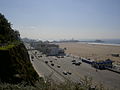
Palisades Park is located atop Santa Monica's cliffs, providing a vantage point to see the Santa Monica Beach and the Pacific Ocean.[5]
The beach is the one featured in the album art for Umbrella Beach by Owl City.
The beach will host beach volleyball and surfing during the 2028 Summer Olympics.[6]
Wildlife
Snowy Plovers nest on the beach.[7][8][9]
In November, 2023, the city announced a plan to restore an additional 5-acre section (2.0 ha) of beach north of the pier into a native coastal strand habitat.[10]
The California Office of Environmental Health Hazard Assessment (OEHHA) has developed a safe eating advisory for fish caught in the Santa Monica Beach based on levels of mercury or PCBs found in local species.[11]
"Ink Well"
A section of the beach was referred to as "Ink Well" and "Negro Beach" in the early 20th century when it was one of the few areas in California where African Americans were allowed to enjoy beach access in a largely segregated society.[12][13] Other areas for blacks were Bruce's Beach in Manhattan Beach and the Pacific Beach Club in Orange County. Nick Gabaldon, one of the first black surfers in California, lived in Santa Monica, and used the 200 foot roped off stretch of beach demarcated for blacks. He died after crashing into the Malibu Pier.[14]
Arlington West

Arlington West was a temporary memorial created on Santa Monica Beach just north of the Santa Monica Pier at Santa Monica, every Sunday from sunrise to sunset. Crosses are placed on the beach for each U.S. military person who has died in the Iraq War. The number of crosses erected every Sunday now exceeds 4,000. For military personnel killed within the week past, flag draped coffins with blue crosses are positioned in front. The Arlington West Memorial, a project of Veterans For Peace, is intended to offer visitors a graceful, visually and emotionally powerful, place for reflection.[15]

Gallery of images
-
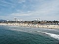 View from ocean
 -
 View from ocean
 -
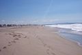 Santa Monica Beach
 -
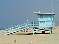 Lifeguard tower
 -
 Casa Del Mar Hotel
 -
 Santa Monica Beach
 -
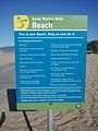 Informational sign
 -
 On the beach 1880
 -
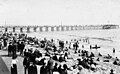
 Santa Monica Beach 1890
 -
 Arcadia Hotel 1890
 -
 Santa Monica Beach 1908
 -
 Steps down the palisades 1915


See also
- List of beaches in California
- List of California state parks
- Santa Monica Pier Aquarium — Aquarium on the pier operated by Heal the Bay, and formerly known as the Ocean Discovery Center
- Pacific Park — the amusement park portion of the pier
- Hot Dog on a Stick — original, opened in 1946, found on the sidewalk just south of the pier in front the original Muscle Beach
- Pacific Ocean Park — former (1958–1967) amusement park one pier south of Santa Monica Pier; demolished in 1974
- Membership discrimination in California social clubs
Notes
- ^ a b "California State Parks: Santa Monica State Beach". Archived from the original on February 22, 2008.
- ^ "City of Santa Monica official beach web site". Archived from the original on October 2, 2013. Retrieved September 29, 2013.
- ^ a b c "Santa Monica Beach". Archived from the original on May 9, 2008.
- ^ "Santa Monica Beach and Bike Path Rules". Archived from the original on October 2, 2013. Retrieved September 29, 2013.
- ^ "LAMountains.com: Santa Monica State Beach". Archived from the original on April 5, 2008.
- ^ "Archived copy" (PDF). Archived (PDF) from the original on October 12, 2016. Retrieved January 30, 2018.
{{cite web}}: CS1 maint: archived copy as title (link) - ^ Sahagun, Louis (May 9, 2017). "Rare birds find Southern California beach housing". LA Times. Archived from the original on August 27, 2017. Retrieved August 26, 2017.
- ^ Borrell, Brendan (August 1, 2018). "Are We Grooming Beaches to Death?". Hakai Magazine. Retrieved April 30, 2020 – via Smithsonian Magazine.
- ^ Bird, Hannah (June 23, 2023). "Coastal erosion could be reduced by dune restoration projects". Phys.org. Retrieved June 24, 2023.
- ^ "5-Acres Of Santa Monica Strand To Be Restored". Santa Monica, CA Patch. November 9, 2023. Retrieved November 10, 2023.
- ^ Admin, OEHHA (December 30, 2014). "Santa Monica Beach south of Santa Monica Pier to Seal Beach Pier". OEHHA. Retrieved June 13, 2018.
- ^ "Ocean Park Neighborhood Beach: The Significance of the "Inkwell" in Jim Crow-Era Southern California". The Cultural Landscape Foundation. Retrieved April 29, 2020.
- ^ "The Bay Street Beach". Santa Monica Conservancy. Retrieved April 30, 2020.
- ^ Alam, Adnan (July 11, 2022). "Nick Gabaldón, a pioneer for Black surfers, is honored for inspiring others". Cronkite News. Retrieved November 10, 2023.
- ^ "Arlington West Memorial Santa Monica". Veterans for Peace. Archived from the original on October 12, 2006.
External links
Wikimedia Commons has media related to Santa Monica State Beach.
- City of Santa Monica: official Santa Monica State Beach website
- California State Parks: official Santa Monica State Beach website
- Santa Monica Beach Archived 2008-05-09 at the Wayback Machine
- LAMountains.com: Santa Monica State Beach
- v
- t
- e
- 1964: Komazawa Volleyball Courts, Yokohama Cultural Gymnasium (final)
- 1968: Juan de la Barrera Olympic Gymnasium (final), Juan Escutia Sports Palace, Revolution Ice Rink
- 1972: Volleyballhalle
- 1976: Montreal Forum (final), Paul Sauvé Centre
- 1980: Druzhba Multipurpose Arena, Minor Arena of the Central Lenin Stadium (final)
- 1984: Long Beach Arena
- 1988: Hanyang University Gymnasium, Jamsil Gymnasium (final), Saemaul Sports Hall
- 1992: Palau dels Esports de Barcelona, Palau Sant Jordi (final), Pavelló de la Vall d'Hebron
- 1996: Clayton County International Park (2-man), Omni Coliseum (indoor final), Stegeman Coliseum

- 2000: Bondi Beach, Sydney Entertainment Centre (indoor final), Sydney Showground Pavilion 4
- 2004: Faliro Olympic Beach Volleyball Centre, Peace and Friendship Stadium
- 2008: Beijing Institute of Technology Gymnasium, Capital Indoor Stadium (indoor final), Chaoyang Park Beach Volleyball Ground
- 2012: Earls Court Exhibition Centre, Horse Guards Parade
- 2016: Copacabana Beach, Maracanãzinho
- 2020: Ariake Arena, Shiokaze Park
- 2024: Paris Expo Porte de Versailles, Champ de Mars
- 2028: Honda Center, Santa Monica State Beach
- 2032: Coomera Indoor Sports Centre, Broadbeach, Queensland, Gold Coast Convention and Exhibition Centre


