State park in San Diego, California
32°32′36″N 117°6′23″W / 32.54333°N 117.10639°W / 32.54333; -117.10639| Area | 1,316 acres (5.33 km2) |
|---|
| Established | 1972 |
|---|
| Visitors | 62,000[1] (in FY 2014/2015) |
|---|
| Governing body | California Department of Parks and Recreation |
|---|
| Website | http://www.parks.ca.gov/?page_id=664 |
|---|
Border Field State Park is a state park of California, United States, containing beach and coastal habitat on the Mexico–United States border. The park is within the city limits of Imperial Beach in San Diego County, next to the suburb of Playas de Tijuana in Mexico. It contains the southernmost point in the state of California.[2] The refuge forms the southern part of the Tijuana River National Estuarine Research Reserve.
Border Field State Park contains International Friendship Park, which is just inland from the place where the border meets the ocean. Immediately adjacent is the monument marking the Initial Point of Boundary Between U.S. and Mexico.
History
The Treaty of Guadalupe Hidalgo was concluded on February 2, 1848, officially ending the war between the United States and Mexico. It provided that the new international border between the two countries be established by a joint United States and Mexican Boundary Survey. The commission began its survey at Border Field. During World War II it was base for Border Naval Outlying Landing Field[2][3][4][5]
Habitat
The Tijuana River National Estuarine Research Reserve contains much of Border Field State Park and is an important wildlife habitat. The salt and freshwater marshes give refuge to migrating waterfowl and resident wading birds, such as black-necked stilt, American avocet, green-winged teal, American wigeon and pelicans. The park offers hiking, horse trails, surf fishing and birding.[2]
Visitors
For fiscal year 2014–2015 61,799 people visited the Border Field State Park,[1] up from 45,633 in FY 2011–2012.[6]
See also
References
- ^ a b "California State Park System Statistical Report 2014/15 Fiscal Year" (PDF). Statewide Planning Unit Planning Division California State Parks. pp. 32–33. Retrieved June 6, 2016.
- ^ a b c "Border Field SP". California State Parks. Retrieved October 2, 2011.
- ^ Abandoned & Little-Known Airfields: California - Southern San Diego area
- ^ sunnycv.com Military Bases in the South Bay
- ^ Van Wormer, Stephen R. "A Land Use History of the Tia Juana River Valley," California State Parks, Southern Service Center, June 2005.
- ^ "California State Park System Statistical Report 2011/12 Fiscal Year" (PDF). Statewide Planning Unit Planning Division California State Parks. pp. 28–29. Archived from the original (PDF) on July 1, 2014. Retrieved June 18, 2014.
External links
Wikimedia Commons has media related to Border Field State Park.
|
|---|
| Parks | |
|---|
| Preserves | |
|---|
| Monuments | |
|---|
| Seashores | |
|---|
| Historical Parks | |
|---|
| Historic Sites | |
|---|
| Memorials | |
|---|
| Recreation Areas | |
|---|
|
|
|
|---|
| Parks | |
|---|
| Natural Reserves | |
|---|
| Marine Reserves | |
|---|
| Historic Parks | |
|---|
| Beaches | |
|---|
| Recreation Areas | |
|---|
Vehicular
Recreation Areas | |
|---|
| Other | |
|---|
|
|
National Forests and Grasslands |
|---|
National Forests
and Grasslands | |
|---|
National Wilderness
Preservation System | |
|---|
National Monuments
and Recreation Areas | |
|---|
|
|
|
|
|
|---|
Wildlife
Areas | |
|---|
Ecological
Reserves | |
|---|
Marine
Protected
Areas | |
|---|
|
|
|
|---|
| National Monuments | |
|---|
National
Conservation Areas | - California Desert
- King Range
|
|---|
| Wilderness Areas | |
|---|
|
|
|
|
|
|
|
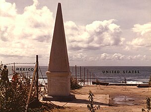 1974 border
 2008 border. (Border Patrol vehicles present in image)
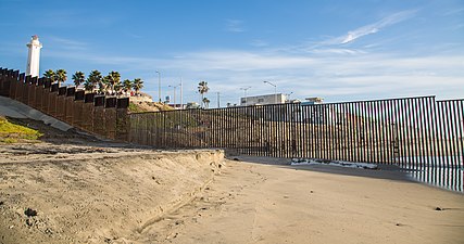 2014 border


