West Didsbury tram stop
Manchester Metrolink tram stop
| Preceding station | Following station | |||
|---|---|---|---|---|
| Didsbury Village towards East Didsbury | East Didsbury–Rochdale | Burton Road towards Rochdale Town Centre | ||
| East Didsbury–Shaw (peak only) | Burton Road towards Shaw and Crompton | |||
| Disused railways | ||||
| Chorlton-cum-Hardy Line closed, station open | Midland Railway South District Railway | Didsbury Line and station closed | ||
Route map | |||||||||||||||||||||||||||||||||||||||||||||||||||||||||||||||||||||||||||||||||||||||||||||||
|---|---|---|---|---|---|---|---|---|---|---|---|---|---|---|---|---|---|---|---|---|---|---|---|---|---|---|---|---|---|---|---|---|---|---|---|---|---|---|---|---|---|---|---|---|---|---|---|---|---|---|---|---|---|---|---|---|---|---|---|---|---|---|---|---|---|---|---|---|---|---|---|---|---|---|---|---|---|---|---|---|---|---|---|---|---|---|---|---|---|---|---|---|---|---|---|
| |||||||||||||||||||||||||||||||||||||||||||||||||||||||||||||||||||||||||||||||||||||||||||||||


Location | |
|---|---|
 |
West Didsbury is a tram stop on the South Manchester Line (SML) of Greater Manchester's light-rail Metrolink system. It opened to passengers on 23 May 2013,[1][2] in West Didsbury, South Manchester, England.[3][4]
The Metrolink stop sits some 300m south east of the former heavy rail station of the Midland Railway, which opened 1 January 1880 as Withington; was renamed on 1 July 1884 to Withington and Albert Park; renamed again on 1 April 1915 to Withington and West Didsbury; and closed 3 July 1961. The route was earmarked for redevelopment with a light rail system during the 1980s, and was confirmed and funded as part of Metrolink's Phase 3b of expansion in 2006.
Service pattern
- 12 minute service to Shaw and Crompton, with double trams at peak times;
- 12 minute service to Rochdale Town Centre, with double trams at peak times;
- 6 minute service to East Didsbury, with double trams at peak times.
History
Railway station
Withington and West Didsbury railway station opened in 1880 as "Withington" when the Midland Railway opened its new Manchester South District Line out of Manchester Central Station. The station was renamed "Withington & Albert Park" in 1884 and then "Withington & West Didsbury" in 1915.[5][6]
The station closed in July 1961, although local services to other stations on the Manchester South District line continued to pass through until January 1967, and express trains continued to use this route until 1969, when the entre line was closed as part of the Beeching cuts. By the 2000s, the original cobbled station approach road and wall were still visible off Lapwing Lane, and the remains of the station platforms could still be seen at the bottom of the overgrown embankment.[6]
Metrolink stop
In 1984, Greater Manchester Council and GMPTE announced the Project Light Rail scheme to develop a new light rail/tram system by re-opening use of disused railway lines in the region, including the route through West Didsbury.[7] The first phase of the Manchester Metrolink system opened in 1992, but it was not until 2013 that the network was expanded to reach as far as East Didsbury, as part of Phase 3b of the Metrolink expansion project. Tram tracks were laid along the former trackbed and a new tram stop was constructed in the railway cutting on the opposite side of Palatine Road from the original railway station. The West Didsbury Metrolink stop opened on 23 May 2013.[1][8]
-
 Midland Railway lines out of Manchester, showing the Manchester South District line
 -
 1911 OS map of West Didsbury, showing the old railway station to the north of the present tram stop
 -
 The disused railway line (pictured in 2008)
 -
 The disused railway line (pictured in 2011)
 -
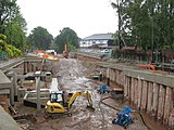 Construction of the new West Didsbury Metrolink strop in 2011
 -
 Map of Didsbury showing the locations of the old station and the tram stop


See also
References
- ^ a b "Early doors for East Didsbury's new Metrolink line". Transport for Greater Manchester. Retrieved 14 May 2013.
- ^ "First passengers travel on tram extension to East Didsbury". Manchester Evening News. 23 May 2013. Retrieved 23 May 2013.
- ^ "Tram line extension is approved". BBC News. 13 May 2009. Retrieved 17 May 2009.
- ^ "Metrolink: back on track?". BBC Manchester. 13 May 2009. Retrieved 17 May 2009.
- ^ Sussex, Gay; Helm, Peter (1988). Looking Back at Withington and Didsbury. Timperley: Willow Publishing. p. 22. ISBN 0-946361-25-8.
- ^ a b "Withington and West Didsbury". Disused Stations: Closed Railway Stations in the UK. Retrieved 27 May 2012.
- ^ Ogden, Eric; Senior, John (1991). Metrolink: Official Handbook. Glossop, Derbyshire: Transport Publishing Company. pp. 26–27. ISBN 0-86317-164-8.
- ^ "Metrolink - South Manchester line". Transport for Greater Manchester. Retrieved 19 May 2013.
External links
Wikimedia Commons has media related to West Didsbury Metrolink station.
- "Withington & West Didsbury Station (1880-1961)". Disused Stations. Retrieved 23 October 2020.
- "Map of West Didsbury Metrolink Stop" (PDF). GMPTE. 2009. Archived from the original (PDF) on 11 June 2015. Retrieved 6 November 2017.
- Metrolink stop information
- West Didsbury area map

| ||||||||||||||||||||||||||
|---|---|---|---|---|---|---|---|---|---|---|---|---|---|---|---|---|---|---|---|---|---|---|---|---|---|---|
| Tram stops |
|   | ||||||||||||||||||||||||
| Operations |
| |||||||||||||||||||||||||
| History (Timeline) |
| |||||||||||||||||||||||||
| Proposed developments |
| |||||||||||||||||||||||||


