Weengallon
Suburb of Goondiwindi Region, Queensland, Australia
28°21′30″S 149°06′14″E / 28.3583°S 149.1038°E / -28.3583; 149.1038 (Weengallon (centre of locality))Weengallon is a rural locality in the Goondiwindi Region, Queensland, Australia.[2] In the 2021 census, Weengallon had a population of 46 people.[1]
The Barwon Highway goes through the locale.
History
The significant cultural area of the Ngaru-gi Gali ('to drink') or Weengallon rock wells are four large water holes, some twelve metres deep, and several smaller ones. These wells were used by the Indigenous Australians, including the Kalkadoon as they moved from Mount Isa south for ceremonies and business towards Goondiwindi, and further coastal towards the Bunya Mountains. Another rock well exists at Thornby on the Moonie Highway near Saint George (27°58′09″S 148°56′18″E / 27.969052°S 148.938276°E / -27.969052; 148.938276 (Thornby significant cultural area)).
-
 Weengallon Aboriginal rock wells (2021).
 -
 A large rock well (2021).


The Weengallon property was in existence by 1867, although in July that year, the 80 square miles (210 km2) run was forfeited for sale.[3] While for cattle, it was noted in 1906 that there was not always water, and a distance from a railway station or siding.[4] A water bore was subsequently sunk in 1911,[5] later down to 3,000 feet (910 m).[6]
A Weengallon Progress Association was in existence by 1913.[7]
By the 1930s, the locale had a public hall,[8] and hosted a ball by Queensland Country Women's Association,[9] cricket, and later, an annual Catholic Ball.[10]
The locality was officially named and bounded on 26 November 1999.[2]
Demographics
In the 2016 census, Weengallon had a population of 30 people.[11]
In the 2021 census, Weengallon had a population of 46 people.[1]
Gallery
-
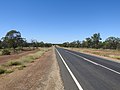 Barwon Highway between Gradna and Weengallon (2021).
 -
 Barwood Highway towards Weengallon (2021).
 -
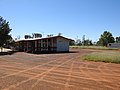 Weengallon community hall and tennis courts (2021).
 -
 Our Lady Queen church (2021).


References
- ^ a b c Australian Bureau of Statistics (28 June 2022). "Weengallon (SAL)". 2021 Census QuickStats. Retrieved 28 February 2023.

- ^ a b "Weengallon – locality in Goondiwindi Region (entry 47836)". Queensland Place Names. Queensland Government. Retrieved 27 December 2020.
- ^ "Sale of forfeited runs". The Darling Downs Gazette and General Advertiser. Vol. XVII, no. 2402. Queensland, Australia. 12 July 1876. p. 3 (Supplement to the Gazette.). Retrieved 16 April 2021 – via National Library of Australia.
- ^ "The South-West". The Brisbane Courier. Vol. LXIII, no. 15, 137. Queensland, Australia. 18 July 1906. p. 5. Retrieved 16 April 2021 – via National Library of Australia.
- ^ "07 Jun 2011". Balonne Beacon. Vol. 3, no. 43. Queensland, Australia. 7 June 1911. Retrieved 16 April 2021.
- ^ "Weengallon bore". The Telegraph. No. 12, 643. Queensland, Australia. 28 May 1913. p. 11 (Second edition). Retrieved 16 April 2021 – via National Library of Australia.
- ^ "Balonne Shire Council". Balonne Beacon. Vol. 5, no. 39. Queensland, Australia. 17 May 1913. p. 2. Retrieved 16 April 2021 – via National Library of Australia.
- ^ "Weengallon". Balonne Beacon. Vol. XXV, no. 4. Queensland, Australia. 29 January 1931. p. 10. Retrieved 16 April 2021 – via National Library of Australia.
- ^ "Weengallon". Balonne Beacon. Vol. XXI, no. 47. Queensland, Australia. 24 November 1927. p. 1. Retrieved 16 April 2021 – via National Library of Australia.
- ^ "Weengallon Ball". Balonne Beacon. Vol. 49, no. 37. Queensland, Australia. 17 September 1953. p. 3. Retrieved 16 April 2021 – via National Library of Australia.
- ^ Australian Bureau of Statistics (27 June 2017). "Weengallon (SSC)". 2016 Census QuickStats. Retrieved 20 October 2018.
- v
- t
- e
Towns and localities in the Goondiwindi Region, Queensland
- Beebo
- Billa Billa
- Bonshaw
- Boondandilla
- Brush Creek
- Bungunya
- Bybera
- Calingunee
- Callandoon
- Canning Creek
- Cement Mills
- Coolmunda
- Daymar
- Glenarbon
- Goodar
- Goondiwindi
- Gore
- Greenup
- Inglewood
- Kindon
- Kioma
- Kurumbul
- Limevale
- Lundavra
- Maidenhead
- Moonie
- Mosquito Creek
- Mungindi
- North Bungunya
- North Talwood
- Oman Ama
- Riverton
- Silver Spur
- Smithlea
- South Talwood
- Talwood
- Tarawera
- Terrica
- Texas
- Toobeah
- Warroo
- Watsons Crossing
- Weengallon
- Whetstone
- Wondalli
- Wyaga
- Yagaburne
- Yelarbon
Main Article: Local government areas of Queensland
 | This Queensland location article is a stub. You can help Wikipedia by expanding it. |
- v
- t
- e


