Talwood, Queensland
Map all coordinates using OpenStreetMap
Download coordinates as:
- KML
- GPX (all coordinates)
- GPX (primary coordinates)
- GPX (secondary coordinates)
Town in Queensland, Australia
28°29′07″S 149°28′05″E / 28.48528°S 149.46806°E / -28.48528; 149.46806 (Talwood (town centre))- 89.4 km (56 mi) W of Goondiwindi
- 112 km (70 mi) SE of St George
- 307 km (191 mi) WSW of Toowoomba
- 438 km (272 mi) WSW of Brisbane
Talwood is a town in the rural locality of North Talwood in Goondiwindi Region, Queensland, Australia.[1]
Geography
Talwood is at the southern edge of the locality of North Talwood, immediately north of the boundary of South Talwood.[2]
Talwood is on the South-Western railway line and is served by Talwood railway station (28°29′05″S 149°28′06″E / 28.4846°S 149.4683°E / -28.4846; 149.4683 (Talwood railway station)).[3][4]
History
Gamilaraay (Gamilaroi, Kamilaroi, Comilroy) is a language from South-West Queensland and North-West New South Wales. The Gamilaraay language region includes the landscape within the local government boundaries of the Balonne Shire Council, including the towns of Dirranbandi, Thallon, Talwood and Bungunya as well as the border towns of Mungindi and Boomi extending to Moree, Tamworth and Coonabarabran in New South Wales.[5]
The town's name is believed to be a corruption of Dalwood, a pastoral run name used from 1844, which was believed to be derived from an Aboriginal word. In 1903, it was spelled Tallwood on a survey plan with an annotation that it has been altered to Talwood, a name which was shown on a 1911 survey plan.[1]
Tallwood Provisional School opened on 1911 but closed in the same year. Talwood State School opened on 4 November 1918 [6]
Education
Talwood State School is a government primary (Prep-6) school for boys and girls at 17 Recreation Street (28°29′12″S 149°28′13″E / 28.4866°S 149.4703°E / -28.4866; 149.4703 (Talwood State School)).[7][8] In 2018, the school had an enrolment of 28 students with 4 teachers (3 full-time equivalent) and 5 non-teaching staff (2 full-time equivalent).[9]
There is no secondary school in Talwood. The nearest secondary school is Goondiwindi State High School in Goondiwindi to the east, but due to the distance, other options would be distance education and boarding school.[10]
Amenities
Talwood Post Office is at 25 Main Street (28°29′07″S 149°28′09″E / 28.4854°S 149.4692°E / -28.4854; 149.4692 (Talwood Post Office)).[11]
Gallery
-
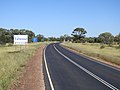 Eastern entrance to town (2021).
 -
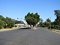
 Barwon Highway turn-off to Talwood township (2021).
 -
 Looking west down Main Street (2021).
 -
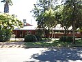 Talwood Community Centre, Main Street (2021).
 -
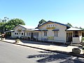 Talwood Hotel, Main Street (2021).
 -
 Talwood State School, Recreation Street (2021).
 -
 Talwood war memorial, park, Recreation Street (2021).
 -
 Talwood Police Station, Main Street (2021).
 -
 Saint Paul's Anglican Church, Main Street (2021).
 -
 Talwood Community Garden, Recreation Street (2021).
 -
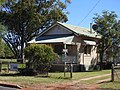
 Converted church, 7 Main Street (2021)
 -
 The Dirranbandi Mail arrives at Talwood railway station, 1987


References
- ^ a b "Talwood – town in Goondiwindi Region (entry 33213)". Queensland Place Names. Queensland Government. Retrieved 4 July 2017.
- ^ "Talwood – population centre in Goondiwindi Regional (entry 33213)". Queensland Place Names. Queensland Government. Retrieved 23 October 2020.
- ^ "Talwood – population centre in Goondiwindi Regional (entry 33213)". Queensland Place Names. Queensland Government. Retrieved 23 October 2020.
- ^ "Railway stations and sidings - Queensland". Queensland Open Data. Queensland Government. 27 August 2020. Archived from the original on 5 October 2020. Retrieved 5 October 2020.
- ^ "Indigenous Language map of Queensland". State Library of Queensland. Archived from the original on 2 September 2020. Retrieved 23 January 2020.
- ^ Queensland Family History Society (2010), Queensland schools past and present (Version 1.01 ed.), Queensland Family History Society, ISBN 978-1-921171-26-0
- ^ "State and non-state school details". Queensland Government. 9 July 2018. Archived from the original on 21 November 2018. Retrieved 21 November 2018.
- ^ "Talwood State School". Talwood State School. 29 November 2020. Retrieved 15 February 2023.
- ^ "ACARA School Profile 2018". Australian Curriculum, Assessment and Reporting Authority. Archived from the original on 27 August 2020. Retrieved 28 January 2020.
- ^ "Queensland Globe". State of Queensland. Retrieved 23 October 2020.
- ^ "Talwood LPO". Australia Post. Archived from the original on 28 November 2020. Retrieved 27 December 2020.
External links
Wikimedia Commons has media related to Talwood, Queensland.
- Town map of Talwood, 1974
- v
- t
- e
Towns and localities in the Goondiwindi Region, Queensland
- Beebo
- Billa Billa
- Bonshaw
- Boondandilla
- Brush Creek
- Bungunya
- Bybera
- Calingunee
- Callandoon
- Canning Creek
- Cement Mills
- Coolmunda
- Daymar
- Glenarbon
- Goodar
- Goondiwindi
- Gore
- Greenup
- Inglewood
- Kindon
- Kioma
- Kurumbul
- Limevale
- Lundavra
- Maidenhead
- Moonie
- Mosquito Creek
- Mungindi
- North Bungunya
- North Talwood
- Oman Ama
- Riverton
- Silver Spur
- Smithlea
- South Talwood
- Talwood
- Tarawera
- Terrica
- Texas
- Toobeah
- Warroo
- Watsons Crossing
- Weengallon
- Whetstone
- Wondalli
- Wyaga
- Yagaburne
- Yelarbon
Main Article: Local government areas of Queensland


