The Channels Natural Area Preserve
Nature preserve in Virginia, US
36°52′0″N 81°59′36″W / 36.86667°N 81.99333°W / 36.86667; -81.99333The Channels Natural Area Preserve is a 721-acre (2.92 km2) Natural Area Preserve located in Washington and Russell counties, Virginia. It was established in April 2008 to protect a number of significant natural communities and habitats, including high-elevation forests, rock outcrops, and cliffs. Its name comes from a cluster of eroded crevices and sandstone boulders located on a portion of the land.[1]
The preserve is part of the Channels State Forest, managed by the Virginia Department of Forestry.[1] The state forest and preserve are both open to the public, though an access permit is required for some activities on state forest lands.[2]
Images and video
- Drone footage of The Channels Natural Area
-
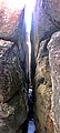
 View within the Great Channels
 -
 View within the Great Channels


See also
References
- ^ a b "The Channels Natural Area Preserve". Virginia Department of Conservation and Recreation. Retrieved December 14, 2016.
- ^ "Channels State Forest" (PDF). Virginia Department of Forestry. Retrieved December 14, 2016.
External links
- Virginia Department of Conservation and Recreation: The Channels Natural Area Preserve
- v
- t
- e
Protected areas of Virginia
| National Parks |
|
|---|---|
| National Historical Parks, Historic Sites & Monuments | |
| National Military Parks, Battlefields & Battlefield Parks | |
| National Cemeteries | |
| National Parkways | |
| National Trails | |
| National Wildlife Refuges | |
| National Forests | |
| USFS National Recreation Areas | |
| Other NPS Areas | |
| Wilderness Areas | |
| National Estuarine Research Reserves |
|
| Registered Historic Places in Virginia |
|---|
This article related to a protected area in Virginia is a stub. You can help Wikipedia by expanding it. |
- v
- t
- e
 | This Russell County, Virginia state location article is a stub. You can help Wikipedia by expanding it. |
- v
- t
- e
| This Washington County, Virginia state location article is a stub. You can help Wikipedia by expanding it. |
- v
- t
- e


