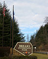
Breaks Interstate Park
State park in Kentucky and Virginia, US
37°17′47″N 82°17′49″W / 37.29639°N 82.29694°W / 37.29639; -82.29694Breaks Interstate Park, also known as "the Breaks," is a bi-state state park located partly in southeastern Kentucky and southwestern Virginia in the Jefferson National Forest, at the northeastern terminus of Pine Mountain. The land is managed by an interstate compact between the states of Virginia[2] and Kentucky.[3] It is the only one of two interstate parks in the United States operated jointly under a compact rather than as two separate state park units.[citation needed] The Virginia Department of Conservation and Recreation and the Kentucky Department of Parks are still major partner organizations.[clarification needed]
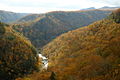
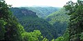
Breaks Interstate Park has been called the "Grand Canyon of the South".[4] Russell Fork river and Clinchfield Railroad (now the CSX Transportation Kingsport Subdivision) both pass through it. It is accessed via Virginia 80 and Kentucky 80 between Haysi, Virginia, and Elkhorn City, Kentucky, and passes through the community of Breaks, Virginia, east of the park.
History
This area was previously covered by a vast inland sea around 180 million years ago.[5] Over subsequent millennia, the Russel Fork gradually carved through the rock to form the spectacular valleys. Early human activity saw the area serve as hunting grounds for Shawnee and Cherokee people. In 1767, American frontiersman Daniel Boone passed through the area looking for an easier westward passage through Pine Mountain.[6] Boone subsequently gave the area its current name, The Breaks.
Preparations have been made to provide elk viewing areas. Elk were seen near the park in 2023 for the first time since the 1800s.[7]
Geography
Breaks Interstate Park is located about 5 miles (8 km) east of Elkhorn City, Kentucky. The park covers 4,500 acres (1,800 ha). The park's main feature, Breaks Canyon, is five miles long and ranges from 830 to 1,600 feet (250 to 490 m) deep. The canyon was formed by the Russell Fork river through millions of years of erosion.[8]
Climate
The climate in this area is characterized by hot, humid summers and generally mild to cool winters. According to the Köppen Climate Classification system, nearby Elkhorn City has a humid subtropical climate, abbreviated "Cfa" on climate maps.[9]
| Climate data for Elkhorn City, Kentucky | |||||||||||||
|---|---|---|---|---|---|---|---|---|---|---|---|---|---|
| Month | Jan | Feb | Mar | Apr | May | Jun | Jul | Aug | Sep | Oct | Nov | Dec | Year |
| Record high °F (°C) | 78 (26) | 83 (28) | 89 (32) | 92 (33) | 98 (37) | 100 (38) | 101 (38) | 100 (38) | 102 (39) | 90 (32) | 85 (29) | 80 (27) | 102 (39) |
| Mean daily maximum °F (°C) | 42 (6) | 47 (8) | 56 (13) | 66 (19) | 73 (23) | 80 (27) | 83 (28) | 82 (28) | 77 (25) | 67 (19) | 57 (14) | 45 (7) | 65 (18) |
| Mean daily minimum °F (°C) | 23 (−5) | 26 (−3) | 32 (0) | 40 (4) | 49 (9) | 59 (15) | 63 (17) | 62 (17) | 55 (13) | 43 (6) | 33 (1) | 26 (−3) | 43 (6) |
| Record low °F (°C) | −14 (−26) | −12 (−24) | −3 (−19) | 21 (−6) | 25 (−4) | 40 (4) | 40 (4) | 45 (7) | 34 (1) | 19 (−7) | 9 (−13) | −11 (−24) | −14 (−26) |
| Average precipitation inches (mm) | 3.19 (81) | 3.20 (81) | 3.43 (87) | 4.06 (103) | 4.89 (124) | 4.50 (114) | 5.20 (132) | 3.86 (98) | 3.14 (80) | 2.82 (72) | 2.91 (74) | 3.27 (83) | 44.47 (1,129) |
| Source: The Weather Channel.[10] | |||||||||||||
Activities
The park provides hiking trails, as well as fishing, paddle boating, canoeing, and hydro biking on Laurel Lake, and white-water rafting on the Russell Fork.[11] Rock climbing with sandstone similar to the nearby New River Gorge. A lodge, cottages and a campground are available.[11] The park has a visitor center with exhibits on the area's historical and natural features, a conference center with restaurant, and an amphitheater.[12]
Gallery
-
-
-

-

-
 A view of Russell Fork
 -
 Russell Fork while flooded


References
- ^ Virginia State Parks 2014 Attendance and Economic Impact Archived April 2, 2015, at the Wayback Machine Virginia Department of Conservation and Recreation. Retrieved 2015-03-17.
- ^ "Virginia State Park Locations". Virginia Department of Conservation and Recreation. 25 June 2013. Retrieved September 24, 2013.
- ^ "About". Breaks Interstate Park. Kentucky Department of Parks. Retrieved September 24, 2013.
- ^ "Breaks Interstate Park". Dickenson County Board of Supervisors. Retrieved February 5, 2024.
- ^ "Our History | Breaks Park".
- ^ "Our History". Breaks Interstate Park Commission. Retrieved September 24, 2013.
- ^ Lee, Murry (2023-02-10). "Elk spotted in Breaks Interstate Park for first time in more than a century". WJHL | Tri-Cities News & Weather. Retrieved 2023-02-12.
- ^ "Breaks Interstate Park". Virginia Tourism Corporation. June 27, 2012. Retrieved September 24, 2013.
- ^ Climate Summary for Elkhorn City, Kentucky
- ^ "Monthly Averages for Elkhorn City, KY". The Weather Channel. Retrieved May 23, 2014.
- ^ a b "Things to do". Breaks Interstate Park. Kentucky Department of Parks. Retrieved September 23, 2013.
- ^ "Amphitheater Music Events". Breaks Interstate Park Commission. Retrieved September 24, 2013.
External links
Wikimedia Commons has media related to Breaks Interstate Park.
 Kentucky portal

- Breaks Interstate Park Breaks Interstate Park Commission
- Breaks Interstate Park Kentucky Department of Parks
- v
- t
- e
| National Parks | |
|---|---|
| National Historical Parks, Historic Sites & Monuments | |
| National Military Parks, Battlefields & Battlefield Parks | |
| National Cemeteries | |
| National Parkways | |
| National Trails | |
| National Wildlife Refuges | |
| National Forests | |
| USFS National Recreation Areas | |
| Other NPS Areas | |
| Wilderness Areas | |
| National Estuarine Research Reserves |
|
| Registered Historic Places in Virginia |
|---|
| ||||||||
|---|---|---|---|---|---|---|---|---|
| Parks |
|      | ||||||
| Museums |
| |||||||
| Forests | ||||||||
| Reservoirs | ||||||||
| Natural features |
| |||||||
| Miscellaneous |
| |||||||
| Authority control databases: National |
|
|---|


