Rough Castle Fort
Ruins of a Roman fort in Scotland


Location in Central Scotland
Show map of Scotland Central Belt
Location in Scotland
Show map of ScotlandRough Castle Fort is a Roman fort on the Antonine Wall roughly 2 kilometres south east of Bonnybridge near Tamfourhill in the Falkirk council area, Scotland.[1] It is owned by the National Trust for Scotland.[2]
Context
The Antonine Wall dates from about 143 AD. The ends of the wall were uncertain for many years. In the east Carriden near Bo'ness on the Forth was a likely endpoint. In the west is Old Kilpatrick on the Clyde, although there were also forts beyond that at Bishopton and Barochan Hill. The fort is one of the best-preserved of the forts constructed along the Wall. Built against the southern rear face of the Wall, the fort was defended by 6 metre thick turf ramparts and surrounded by defensive ditches. Gateways were provided through the main wall to the north, and also through the walls on the other three sides of the fort. Causeways were then constructed across the main Antonine and secondary defensive ditches, affording easy access to and from the fort.
The fort was the second smallest on the Wall and had an area of about 4,000 square metres. The fort contained several buildings, made of stone from a time when this was a less common construction material. The traces of the commander's house, the barracks, the headquarters, the bath house and a granary have been discovered. Although the original buildings have not survived, these buildings' foundations were discovered during excavations in 1902-03, 1932 and 1957-61. A video reconstruction of the site has been produced.[3]
Finds
Inscriptions found on recovered artefacts indicate that the fort based 480 men of the Cohors VI Nerviorum of Nervii, foot soldiers drawn from a north-eastern Gallic tribe. The military road on the south side of the Wall, which enabled transport between all forts, is still well defined and there is also a fine length of rampart and ditch still intact to the west. An altar to Victory was found in 1843 to the south of the fort.[4] Other finds include a bangle, some glass from a window and leather shoes.[5]
A series of pits were discovered during the excavations lying to the north west of the causeway across the Antonine ditch. These pits, known as lilia, would originally have contained sharpened stakes at the bottom. They were positioned to help defend the vulnerable northern gateway through the wall. Near the fort were a turf platform (beacon platform or signalling platform) and gravel pits for building of the military road. The bath house was built on an annexe. The fort was defended by Nervii, and Flavius Betto was a commanding officer.
-
![RIB 2144. Altar dedicated to Victory.[6] George MacDonald calls in no. 34 in the 2nd edition of his book The Roman Wall in Scotland.[7] It has been scanned and a video produced.[8]](//upload.wikimedia.org/wikipedia/commons/thumb/d/db/Romanwallinscotl00macduoft_raw_0329_II.png/148px-Romanwallinscotl00macduoft_raw_0329_II.png)
-
![Tablet from Rough Castle Principia. RIB 2145, dedicated to the emperor Antoninus Pius.[9] George MacDonald calls in no. 29 in the 2nd edition of his book The Roman Wall in Scotland.[10] It has been scanned a video produced.[11]](//upload.wikimedia.org/wikipedia/commons/thumb/2/24/Romanwallinscotl00macduoft_raw_0313.png/236px-Romanwallinscotl00macduoft_raw_0313.png) Tablet from Rough Castle Principia. RIB 2145, dedicated to the emperor Antoninus Pius.[9] George MacDonald calls in no. 29 in the 2nd edition of his book The Roman Wall in Scotland.[10] It has been scanned a video produced.[11]
Tablet from Rough Castle Principia. RIB 2145, dedicated to the emperor Antoninus Pius.[9] George MacDonald calls in no. 29 in the 2nd edition of his book The Roman Wall in Scotland.[10] It has been scanned a video produced.[11] -
 The Granary at Rough Castle Roman Fort, with its tell-tale buttresses at left, from The Roman Wall in Scotland
 -
 A section of the Antonine Wall just to the west of the fort.
 -
 The lilia (defensive pits) north west of the fort
 -
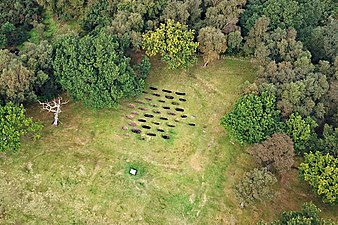 Lilia from the air
 -
![Plan of Rough Castle Fort interior. George MacDonald shows other drawings in the 2nd edition of his book The Roman Wall in Scotland.[12]](//upload.wikimedia.org/wikipedia/commons/thumb/e/ea/Romanwallinscotl00macduoft_raw_0305_01.png/314px-Romanwallinscotl00macduoft_raw_0305_01.png) Plan of Rough Castle Fort interior. George MacDonald shows other drawings in the 2nd edition of his book The Roman Wall in Scotland.[12]
Plan of Rough Castle Fort interior. George MacDonald shows other drawings in the 2nd edition of his book The Roman Wall in Scotland.[12] -
 Rough Castle on the Antonine Wall, drawn by William Roy in 1755
![RIB 2144. Altar dedicated to Victory.[6] George MacDonald calls in no. 34 in the 2nd edition of his book The Roman Wall in Scotland.[7] It has been scanned and a video produced.[8]](http://upload.wikimedia.org/wikipedia/commons/thumb/d/db/Romanwallinscotl00macduoft_raw_0329_II.png/148px-Romanwallinscotl00macduoft_raw_0329_II.png)
![Tablet from Rough Castle Principia. RIB 2145, dedicated to the emperor Antoninus Pius.[9] George MacDonald calls in no. 29 in the 2nd edition of his book The Roman Wall in Scotland.[10] It has been scanned a video produced.[11]](http://upload.wikimedia.org/wikipedia/commons/thumb/2/24/Romanwallinscotl00macduoft_raw_0313.png/236px-Romanwallinscotl00macduoft_raw_0313.png)


![Plan of Rough Castle Fort interior. George MacDonald shows other drawings in the 2nd edition of his book The Roman Wall in Scotland.[12]](http://upload.wikimedia.org/wikipedia/commons/thumb/e/ea/Romanwallinscotl00macduoft_raw_0305_01.png/314px-Romanwallinscotl00macduoft_raw_0305_01.png)

One of the best overviews of the site is the video of the Bridgeness Slab by Falkirk Council,[13] presented by Geoff Bailey, Keeper of Archeology and Local History at Falkirk Museum, from about 10 minutes. For early discoveries see Sir George Macdonald's writings.[14]

Events
A sound and light show was organised at Rough Castle in November 2018 to promote tourism.[15]
See also
References
- ^ "OS 25 inch map 1892-1949, with Bing opacity slider". National Library of Scotland. Ordnance Survey. Retrieved 12 October 2017.
- ^ "Rough Castle". Canmore. Historic Environment Scotland. Retrieved 19 May 2018.
- ^ "RoughCastle_Comp_01". Retrieved 5 December 2018.
- ^ "ROUGH CASTLE: FORT, ETC" (PDF). Frontiers of the Empire. Retrieved 19 May 2018.
- ^ "XFRF411LeatherShoeRoughCastle". Retrieved 9 November 2018.
- ^ "RIB 2144. Altar dedicated to Victory". Roman Inscriptions of Britain. Retrieved 18 November 2017.
- ^ Macdonald, Sir George (1934). The Roman wall in Scotland, by Sir George Macdonald (2d ed., rev., enl., and in great part rewritten ed.). Oxford: The Clarendon press. p. 228. Retrieved 11 October 2017.
- ^ "XFV34AltarRoughCastle". Retrieved 9 November 2018.
- ^ "RIB 2145. Dedication to Emperor Antoninus Pius". Roman Inscriptions of Britain. Retrieved 18 November 2017.
- ^ Macdonald, Sir George (1934). The Roman wall in Scotland, by Sir George Macdonald (2d ed., rev., enl., and in great part rewritten ed.). Oxford: The Clarendon press. p. 228. Retrieved 11 October 2017.
- ^ "XFR376PrincipiaInscriptionRoughCastle". Retrieved 9 November 2018.
- ^ Macdonald, Sir George (1934). The Roman wall in Scotland, by Sir George Macdonald (2d ed., rev., enl., and in great part rewritten ed.). Oxford: The Clarendon press. pp. 219–227. Retrieved 11 October 2017.
- ^ "Roman film now online". Kinneil Estate, Bo'ness. Retrieved 22 October 2017.
- ^ Macdonald, Sir George (1934). The Roman wall in Scotland, by Sir George Macdonald (2d ed., rev., enl., and in great part rewritten ed.). Oxford: The Clarendon press. pp. 217–238. Retrieved 11 October 2017.
- ^ Beers, Roy (7 October 2018). "Falkirk Roman show promises 'a family event like no other'". Falkirk Herald. Retrieved 7 October 2018.
External links
 Media related to Rough Castle at Wikimedia Commons
- Antonine Wall: Rough Castle at Historic Environment Scotland website
- Rough Castle Fort on the Gazetteer for Scotland
- Falkirk Local History Society
Wikimedia Commons has media related to Rough Castle.


