North District, Hong Kong
You can help expand this article with text translated from the corresponding article in Chinese. (April 2023) Click [show] for important translation instructions.
- Machine translation, like DeepL or Google Translate, is a useful starting point for translations, but translators must revise errors as necessary and confirm that the translation is accurate, rather than simply copy-pasting machine-translated text into the English Wikipedia.
- Do not translate text that appears unreliable or low-quality. If possible, verify the text with references provided in the foreign-language article.
- You must provide copyright attribution in the edit summary accompanying your translation by providing an interlanguage link to the source of your translation. A model attribution edit summary is
Content in this edit is translated from the existing Chinese Wikipedia article at [[:zh:北區 (香港)]]; see its history for attribution. - You may also add the template
{{Translated|zh|北區 (香港)}}to the talk page. - For more guidance, see Wikipedia:Translation.
District in New Territories, Hong Kong
District in Hong Kong, China
North District 22°29′41″N 114°08′17″E / 22.49471°N 114.13812°E / 22.49471; 114.13812 | |
|---|---|
| Country | China |
| SAR | Hong Kong |
| Region | New Territories |
| Constituencies | 16 |
| Government | |
| • District Council Chairman | Law Ting-Tak (Independent) |
| • District Council Vice-Chairman | Li Kon-hong |
| • District Officer | Chong Wing-wun |
| Area | |
| • Total | 168 km2 (65 sq mi) |
| Population (2016) | |
| • Total | 315,270 |
| • Density | 1,900/km2 (4,900/sq mi) |
| Time zone | UTC+8 (Hong Kong Time) |
| Website | North District Council |
| North District | |||||||||||||||
|---|---|---|---|---|---|---|---|---|---|---|---|---|---|---|---|
| Traditional Chinese | 北區 | ||||||||||||||
| Simplified Chinese | 北区 | ||||||||||||||
| Jyutping | Bak1 Keoi1 | ||||||||||||||
| |||||||||||||||

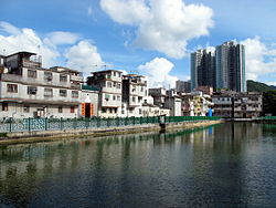
North District (Chinese: 北區) is the northernmost district of the 18 districts of Hong Kong. It is located in the northeastern part of the New Territories. The new town of Fanling–Sheung Shui is within this district. It had a population of 298,657 in 2001. The district has the second lowest population density in Hong Kong.
It borders with Shenzhen city with the Sham Chun River. Most major access points to Mainland China from Hong Kong lie in this district. The North District is about 168 km2 (65 sq mi) in area.
Demographics
According to statistics, 70% of the district population lives in the public estates in the Fanling–Sheung Shui New Town. 40,000 villagers living around the two town centres and the main rural towns (Sha Tau Kok and Ta Kwu Ling) account for most residents in the district.
Islands of the district
- A Chau (鴉洲)
- Ap Chau Mei Pak Tun Pai (鴨洲尾白墩排)
- Ap Chau Pak Tun Pai (鴨洲白墩排)
- Ap Chau (鴨洲, Robinson Island)
- Ap Lo Chun (鴨螺春)
- Ap Tan Pai (鴨蛋排)
- Ap Tau Pai (鴨兜排)
- Chap Mo Chau (執毛洲)
- Cheung Shek Tsui (長石咀)
- Fu Wong Chau (虎王洲)
- Fun Chau (墳洲)
- Hung Pai (紅排)
- Kat O Chau (吉澳洲, Crooked Island)
- Ko Pai (高排)
- Kok Tai Pai (角大排)
- Lan Shuen Pei (爛樹排)
- Lo Chi Pai (鷀鸕排)
- Ngo Mei Chau (娥眉洲, Crescent Island)
- Pak Ka Chau (筆架洲)
- Pak Sha Chau (白沙洲, Round Island)
- Pat Ka Chau (筆架洲)
- Sai Ap Chau (細鴨洲)
- Sha Pai (沙排)
- Shau Kei Pai (筲箕排)
- Sheung Pai (雙排)
- Shui Cham Tsui Pai (水浸咀排)
- Siu Nim Chau (小稔洲)
- Ta Ho Pai (打蠔排)
- Tai Nim Chau (大稔洲)
- Tsing Chau (青洲, Table Island)
- Wong Nai Chau (黃泥洲)
- Wong Nai Chau (黃泥洲)
- Wong Wan Chau (往灣洲, Double Island)
- Wu Chau (烏洲)
- Wu Pai (烏排)
- Wu Yeung Chau Pai (湖洋洲排)
- Yan Chau (印洲)
- Yeung Chau (洋洲)
Education
Miscellaneous
The northern end of the Wilson Trail hiking path is located in the North District. The trail ends at Nam Chung.
Transport
North District is served by the East Rail line, Fanling Highway, San Tin Highway and Sha Tau Kok Road.
MTR Stations
- Fanling station
- Sheung Shui station
- Lo Wu station (terminus of East Rail line)
Border crossings
- Sha Tau Kok (road)
- Man Kam To (road)
- Lo Wu (train)
See also
External links
Wikimedia Commons has media related to North District, Hong Kong.
- North District District Council
- List and map of electoral constituencies 1 (large PDF file)
- List and map of electoral constituencies 2 (large PDF file)
- Fanling-Sheung Shui New Town
- Satellite image of the new town of Fanling-Sheung Shui and its vicinity by Google Maps
Places adjacent to North District, Hong Kong | ||||||||||||||||
|---|---|---|---|---|---|---|---|---|---|---|---|---|---|---|---|---|
| ||||||||||||||||


- v
- t
- e
North District, Hong Kong
- A Chau
- Ap Chau Mei Pak Tun Pai
- Ap Chau Pak Tun Pai
- Ap Chau (Robinson Island)
- Ap Lo Chun
- Ap Tan Pai
- Ap Tau Pai
- Chap Mo Chau
- Cheung Shek Tsui
- Fu Wong Chau
- Fun Chau
- Hung Pai
- Kat O Chau (Crooked Island)
- Ko Pai
- Kok Tai Pai
- Lan Shuen Pei
- Lo Chi Pai
- Ngo Mei Chau (Crescent Island)
- Pak Ka Chau
- Pak Sha Chau (Round Island)
- Pat Ka Chau
- Sai Ap Chau
- Sha Pai
- Shau Kei Pai
- Sheung Pai
- Shui Cham Tsui Pai
- Siu Nim Chau
- Ta Ho Pai
- Tai Nim Chau
- Tsing Chau
- Wong Nai Chau
- Wong Nai Chau
- Wong Wan Chau (Double Island)
- Wu Chau
- Wu Pai
- Wu Yeung Chau Pai
- Yan Chau
- Yeung Chau
This list is incomplete.
| |
|---|---|
District Officers, District councils | |
| Hong Kong Island | |
| Kowloon and New Kowloon | |
| New Territories (excluding New Kowloon) | |


