National Register of Historic Places listings in Scioto County, Ohio

This is a list of the National Register of Historic Places listings in Scioto County, Ohio.
This is intended to be a complete list of the properties and districts on the National Register of Historic Places in Scioto County, Ohio, United States. The locations of National Register properties and districts for which the latitude and longitude coordinates are included below, may be seen in an online map.[1]
There are 42 properties and districts listed on the National Register in the county. Another 2 properties were once listed but have been removed.
This National Park Service list is complete through NPS recent listings posted May 31, 2024.[2]
Map all coordinates using OpenStreetMap
Download coordinates as:
- KML
- GPX (all coordinates)
- GPX (primary coordinates)
- GPX (secondary coordinates)
Current listings
| [3] | Name on the Register[4] | Image | Date listed[5] | Location | City or town | Description |
|---|---|---|---|---|---|---|
| 1 | 100 Mile House | Upload image | March 8, 2021 (#100006197) | 4866 US 52 #D Coordinates missing | Stout | |
| 2 | All Saints Episcopal Church |  | March 25, 1982 (#82003639) | 4th and Court Sts. 38°43′59″N 83°00′02″W / 38.733056°N 83.000556°W / 38.733056; -83.000556 (All Saints Episcopal Church) | Portsmouth | |
| 3 | Anderson Brothers Department Store |  | February 2, 2001 (#01000052) | 301-307 Chillicothe St. 38°43′57″N 82°59′49″W / 38.732500°N 82.996944°W / 38.732500; -82.996944 (Anderson Brothers Department Store) | Portsmouth | |
| 4 | Bennett Schoolhouse Road Covered Bridge |  | October 11, 1978 (#78002185) | Southeast of Minford 38°49′45″N 82°48′26″W / 38.829167°N 82.807222°W / 38.829167; -82.807222 (Bennett Schoolhouse Road Covered Bridge) | Harrison Township | |
| 5 | Bigelow United Methodist Church | 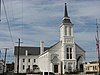 | December 8, 1987 (#87002073) | 415 Washington St. 38°44′02″N 82°59′56″W / 38.733889°N 82.998889°W / 38.733889; -82.998889 (Bigelow United Methodist Church) | Portsmouth | |
| 6 | Boneyfiddle Commercial District |  | June 6, 1979 (#79001938) | Roughly bounded by Front, Washington, 3rd, and Scioto Sts. 38°43′54″N 83°00′19″W / 38.731667°N 83.005278°W / 38.731667; -83.005278 (Boneyfiddle Commercial District) | Portsmouth | |
| 7 | Cunningham-Maier House | 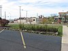 | December 8, 1987 (#87002074) | 506 6th St. 38°44′05″N 83°00′09″W / 38.734722°N 83.002500°W / 38.734722; -83.002500 (Cunningham-Maier House) | Portsmouth | |
| 8 | Dole-Darrell House | 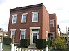 | December 8, 1987 (#87002075) | 322 Market St. 38°43′59″N 83°00′10″W / 38.733139°N 83.002778°W / 38.733139; -83.002778 (Dole-Darrell House) | Portsmouth | |
| 9 | Elden House | 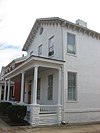 | December 8, 1987 (#87002076) | 634 4th St. 38°43′59″N 82°59′58″W / 38.733056°N 82.999444°W / 38.733056; -82.999444 (Elden House) | Portsmouth | |
| 10 | Evangelical Church of Christ |  | December 8, 1987 (#87002077) | 701 5th St. 38°44′03″N 82°59′54″W / 38.734167°N 82.998472°W / 38.734167; -82.998472 (Evangelical Church of Christ) | Portsmouth | |
| 11 | Feurt Mounds and Village Site |  | June 18, 1973 (#73001531) | Eastern bank of the Scioto River along the western side of U.S. Route 23, north of Portsmouth[6] 38°48′21″N 82°59′19″W / 38.805833°N 82.988611°W / 38.805833; -82.988611 (Feurt Mounds and Village Site) | Clay Township | |
| 12 | First Presbyterian Church |  | November 28, 1973 (#73001532) | 221 Court St. 38°43′56″N 83°00′04″W / 38.732222°N 83.001111°W / 38.732222; -83.001111 (First Presbyterian Church) | Portsmouth | |
| 13 | George H. Gharky House | 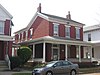 | December 8, 1987 (#87002078) | 638 4th St. 38°43′58″N 82°59′56″W / 38.732778°N 82.998889°W / 38.732778; -82.998889 (George H. Gharky House) | Portsmouth | |
| 14 | General U.S. Grant Bridge |  | May 31, 2001 (#01000560) | Spanning the Ohio River, beginning at the intersection of Chillicothe and 2nd Sts. 38°43′50″N 82°59′49″W / 38.730556°N 82.996944°W / 38.730556; -82.996944 (General U.S. Grant Bridge) | Portsmouth | Extended into Greenup County, Kentucky. Demolished in 2001. |
| 15 | Greenlawn Cemetery Chapel |  | January 3, 1980 (#80003216) | Offnere St. 38°44′38″N 82°59′04″W / 38.743833°N 82.984306°W / 38.743833; -82.984306 (Greenlawn Cemetery Chapel) | Portsmouth | |
| 16 | Horseshoe Mound | 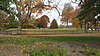 | May 2, 1974 (#74001621) | Within Mound Park 38°44′35″N 82°58′40″W / 38.743056°N 82.977778°W / 38.743056; -82.977778 (Horseshoe Mound) | Portsmouth | |
| 17 | Hurth Hotel |  | July 28, 1983 (#83002056) | 222 Chillicothe St. 38°43′56″N 82°59′48″W / 38.732222°N 82.996667°W / 38.732222; -82.996667 (Hurth Hotel) | Portsmouth | |
| 18 | Aaron Kinney House |  | July 2, 1973 (#73001533) | Waller St. 38°44′51″N 82°59′19″W / 38.7475°N 82.988611°W / 38.7475; -82.988611 (Aaron Kinney House) | Portsmouth | |
| 19 | Eli Kinney House |  | March 10, 1988 (#87002079) | 317 Court St. 38°43′59″N 83°00′04″W / 38.733056°N 83.001111°W / 38.733056; -83.001111 (Eli Kinney House) | Portsmouth | |
| 20 | Labold House and Gardens | 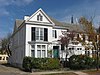 | December 8, 1987 (#87002085) | 633 4th St. 38°44′00″N 82°59′57″W / 38.733333°N 82.999167°W / 38.733333; -82.999167 (Labold House and Gardens) | Portsmouth | |
| 21 | Joseph Marsh House |  | December 8, 1987 (#87002087) | 701 Market St. 38°44′09″N 83°00′11″W / 38.735833°N 83.003056°W / 38.735833; -83.003056 (Joseph Marsh House) | Portsmouth | |
| 22 | Eugene McKinley Memorial Pool | Upload image | August 8, 2019 (#100004233) | 1529 Findlay St. 38°44′36″N 82°59′35″W / 38.743333°N 82.993056°W / 38.743333; -82.993056 (Eugene McKinley Memorial Pool) | Portsmouth | |
| 23 | Meyer House |  | March 10, 1988 (#87002088) | 309 Washington St. 38°43′58″N 82°59′56″W / 38.732778°N 82.998889°W / 38.732778; -82.998889 (Meyer House) | Portsmouth | |
| 24 | Philip Moore Stone House |  | October 21, 1975 (#75001531) | South of West Portsmouth on State Route 239 38°44′36″N 83°02′02″W / 38.743333°N 83.033889°W / 38.743333; -83.033889 (Philip Moore Stone House) | Washington Township | |
| 25 | William Newman House | 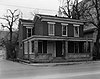 | December 8, 1987 (#87002089) | 716 2nd St. 38°43′53″N 82°59′54″W / 38.731389°N 82.998333°W / 38.731389; -82.998333 (William Newman House) | Portsmouth | |
| 26 | Odd Fellows Hall | 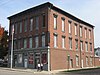 | December 8, 1987 (#87002090) | 500-506 Court St. 38°44′03″N 83°00′02″W / 38.734167°N 83.000556°W / 38.734167; -83.000556 (Odd Fellows Hall) | Portsmouth | |
| 27 | Ohio and Erie Canal Southern Descent Historic District | Upload image | April 1, 2019 (#100003572) | Multiple; Old River Rd. at Slab Run 38°43′34″N 83°01′53″W / 38.7262°N 83.0314°W / 38.7262; -83.0314 (Ohio and Erie Canal Southern Descent Historic District) | Portsmouth vicinity | Boundary increase approved September 2, 2022; extends into other Ohio counties |
| 28 | Otway Covered Bridge |  | May 3, 1974 (#74002280) | North of State Route 348 38°51′46″N 83°11′24″W / 38.862778°N 83.19°W / 38.862778; -83.19 (Otway Covered Bridge) | Otway | |
| 29 | Portsmouth Fire Department No. 1 |  | December 8, 1987 (#87002091) | 642 7th St. 38°44′08″N 82°59′56″W / 38.735556°N 82.998889°W / 38.735556; -82.998889 (Portsmouth Fire Department No. 1) | Portsmouth | |
| 30 | Portsmouth Foundry and Machine Works |  | December 8, 1987 (#87002095) | 401 3rd St. 38°43′57″N 83°00′18″W / 38.7325°N 83.005°W / 38.7325; -83.005 (Portsmouth Foundry and Machine Works) | Portsmouth | |
| 31 | Purdum-Tracy House |  | December 8, 1987 (#87002097) | 626 4th St. 38°43′59″N 82°59′59″W / 38.733056°N 82.999722°W / 38.733056; -82.999722 (Purdum-Tracy House) | Portsmouth | |
| 32 | Joseph G. Reed Company | 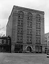 | December 8, 1987 (#87002099) | 700 2nd St. 38°43′53″N 82°59′56″W / 38.731389°N 82.998889°W / 38.731389; -82.998889 (Joseph G. Reed Company) | Portsmouth | |
| 33 | St. Mary's Roman Catholic Church |  | August 24, 1979 (#79001940) | 5th and Market Sts. 38°44′04″N 83°00′08″W / 38.734333°N 83.002222°W / 38.734333; -83.002222 (St. Mary's Roman Catholic Church) | Portsmouth | |
| 34 | Scioto County Courthouse | 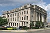 | December 8, 1987 (#87002101) | Bounded by 7th, Court, 6th, and Washington Sts. 38°44′07″N 83°00′01″W / 38.735278°N 83.000278°W / 38.735278; -83.000278 (Scioto County Courthouse) | Portsmouth | |
| 35 | Second Presbyterian Church | 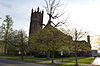 | August 22, 1996 (#96000926) | 801 Waller St. 38°44′11″N 82°59′24″W / 38.736389°N 82.990000°W / 38.736389; -82.990000 (Second Presbyterian Church) | Portsmouth | |
| 36 | Second Street Historic District | 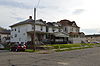 | November 30, 1983 (#83004336) | 2nd St. 38°43′52″N 82°59′25″W / 38.731111°N 82.990278°W / 38.731111; -82.990278 (Second Street Historic District) | Portsmouth | |
| 37 | Sixth Street Historic District |  | March 10, 1988 (#87002103) | 533, 534, 537, 538, 541, 542, 543, 547, and 548 6th St., west of Court St. 38°44′05″N 83°00′04″W / 38.734722°N 83.001111°W / 38.734722; -83.001111 (Sixth Street Historic District) | Portsmouth | |
| 38 | Steindam House | 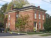 | December 8, 1987 (#87002104) | 725 Court St. 38°44′12″N 83°00′03″W / 38.736528°N 83.000833°W / 38.736528; -83.000833 (Steindam House) | Portsmouth | |
| 39 | Streich Apartments |  | December 8, 1987 (#87002105) | 716-722 Washington St. 38°44′10″N 82°59′54″W / 38.736111°N 82.998333°W / 38.736111; -82.998333 (Streich Apartments) | Portsmouth | |
| 40 | Tremper Mound and Works | 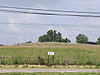 | December 8, 1972 (#72001041) | West of State Routes 73 and 104 north of West Portsmouth[7] 38°48′06″N 83°00′36″W / 38.8017°N 83.01°W / 38.8017; -83.01 (Tremper Mound and Works) | Rush Township | |
| 41 | Tripp-Bauer Building |  | June 9, 1988 (#88000719) | 51-53 N. Jackson St. 38°49′00″N 82°43′34″W / 38.816667°N 82.726111°W / 38.816667; -82.726111 (Tripp-Bauer Building) | South Webster | |
| 42 | Zottman House | 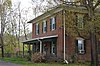 | August 8, 1996 (#96000882) | 11 Offnere St. 38°43′46″N 82°59′09″W / 38.729583°N 82.985833°W / 38.729583; -82.985833 (Zottman House) | Portsmouth |
Former listings
| [3] | Name on the Register | Image | Date listed | Date removed | Location | City or town | Description |
|---|---|---|---|---|---|---|---|
| 1 | Lyric Theater | Upload image | May 15, 1974 (#74001622) | December 1, 1974 | 820 Gallia Street 38°44′04″N 82°59′43″W / 38.7344°N 82.9954°W / 38.7344; -82.9954 (Lyric Theater) | Portsmouth | |
| 2 | Judge William V. Peck House |  | November 15, 1979 (#79001939) | January 31, 1995 | 601 Market St. 38°44′03″N 83°00′11″W / 38.7342°N 83.0031°W / 38.7342; -83.0031 (Judge William V. Peck House) | Portsmouth |
See also
Wikimedia Commons has media related to National Register of Historic Places in Scioto County, Ohio.
- List of National Historic Landmarks in Ohio
- Listings in neighboring counties: Adams, Greenup (KY), Jackson, Lawrence, Lewis (KY), Pike
- National Register of Historic Places listings in Ohio
References
- ^ The latitude and longitude information provided in this table was derived originally from the National Register Information System, which has been found to be fairly accurate for about 99% of listings. Some locations in this table may have been corrected to current GPS standards.
- ^ National Park Service, United States Department of the Interior, "National Register of Historic Places: Weekly List Actions", retrieved May 31, 2024.
- ^ a b Numbers represent an alphabetical ordering by significant words. Various colorings, defined here, differentiate National Historic Landmarks and historic districts from other NRHP buildings, structures, sites or objects.
- ^ "National Register Information System". National Register of Historic Places. National Park Service. April 24, 2008.
- ^ The eight-digit number below each date is the number assigned to each location in the National Register Information System database, which can be viewed by clicking the number.
- ^ Location derived from Mills, William C. Archeological Atlas of Ohio. Columbus: Ohio State Archeological and Historical Society, 1914, page 73 and plate 73. The NRIS lists the site as "Address Restricted".
- ^ Location derived from its GNIS feature record; the NRIS lists the site as "Address Restricted"
- v
- t
- e
by county
- Adams
- Allen
- Ashland
- Ashtabula
- Athens
- Auglaize
- Belmont
- Brown
- Butler
- Carroll
- Champaign
- Clark
- Clermont
- Clinton
- Columbiana
- Coshocton
- Crawford
- Cuyahoga
- Darke
- Defiance
- Delaware
- Erie
- Fairfield
- Fayette
- Franklin
- Fulton
- Gallia
- Geauga
- Greene
- Guernsey
- Hamilton
- Hancock
- Hardin
- Harrison
- Henry
- Highland
- Hocking
- Holmes
- Huron
- Jackson
- Jefferson
- Knox
- Lake
- Lawrence
- Licking
- Logan
- Lorain
- Lucas
- Madison
- Mahoning
- Marion
- Medina
- Meigs
- Mercer
- Miami
- Monroe
- Montgomery
- Morgan
- Morrow
- Muskingum
- Noble
- Ottawa
- Paulding
- Perry
- Pickaway
- Pike
- Portage
- Preble
- Putnam
- Richland
- Ross
- Sandusky
- Scioto
- Seneca
- Shelby
- Stark
- Summit
- Trumbull
- Tuscarawas
- Union
- Van Wert
- Vinton
- Warren
- Washington
- Wayne
- Williams
- Wood
- Wyandot


