National Register of Historic Places listings in Pickaway County, Ohio

This is a list of the National Register of Historic Places listings in Pickaway County, Ohio, USA.
This is intended to be a complete list of the properties and districts on the National Register of Historic Places in Pickaway County, Ohio. The locations of National Register properties and districts for which the latitude and longitude coordinates are included below, may be seen in an online map.[1]
There are 33 properties and districts listed on the National Register in the county.
This National Park Service list is complete through NPS recent listings posted May 3, 2024.[2]
Map all coordinates using OpenStreetMap
Download coordinates as:
- KML
- GPX (all coordinates)
- GPX (primary coordinates)
- GPX (secondary coordinates)
Current listings
| [3] | Name on the Register[4] | Image | Date listed[5] | Location | City or town | Description |
|---|---|---|---|---|---|---|
| 1 | William Marshall Anderson House | 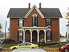 | November 29, 1979 (#79001925) | 131 W. Union St. 39°35′57″N 82°56′50″W / 39.599167°N 82.947222°W / 39.599167; -82.947222 (William Marshall Anderson House) | Circleville | |
| 2 | Adams Archeological Preserve |  | July 30, 1974 (#74001591) | Off State Route 56 southeast of Circleville[6] 39°33′00″N 82°52′27″W / 39.550000°N 82.874167°W / 39.550000; -82.874167 (Adams Archeological Preserve) | Pickaway Township | Private Property [7] |
| 3 | Ashville Depot |  | February 25, 1980 (#80003209) | Madison and Cromley Sts. 39°42′54″N 82°57′20″W / 39.715°N 82.955556°W / 39.715; -82.955556 (Ashville Depot) | Ashville | |
| 4 | Bazore Mill |  | December 19, 1978 (#78002172) | South of Williamsport on State Route 138 at Deer Creek 39°33′04″N 83°06′31″W / 39.551111°N 83.108611°W / 39.551111; -83.108611 (Bazore Mill) | Deer Creek Township | |
| 5 | Bellevue | 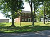 | March 17, 1976 (#76001508) | North of Kingston on State Route 159 39°29′01″N 82°54′07″W / 39.483611°N 82.901944°W / 39.483611; -82.901944 (Bellevue) | Pickaway Township | |
| 6 | Joseph Black Farmhouse |  | August 9, 1982 (#02001459) | 9862 Heffner Rd. 39°30′51″N 82°50′47″W / 39.514047°N 82.846325°W / 39.514047; -82.846325 (Joseph Black Farmhouse) | Pickaway Township | |
| 7 | Granville M. Bulen House and Farm Complex |  | February 24, 2014 (#14000028) | 10001 Bulen-Pierce Rd., south of Lockbourne 39°47′14″N 82°58′34″W / 39.787333°N 82.976111°W / 39.787333; -82.976111 (Granville M. Bulen House and Farm Complex) | Harrison Township | |
| 8 | Circleville High School |  | August 31, 2015 (#15000576) | 520 S. Court St. 39°35′48″N 82°56′49″W / 39.596667°N 82.946944°W / 39.596667; -82.946944 (Circleville High School) | Circleville | |
| 9 | Circleville Historic District |  | May 16, 1978 (#78002171) | Main and Court Sts. 39°36′07″N 82°56′42″W / 39.601903°N 82.945097°W / 39.601903; -82.945097 (Circleville Historic District) | Circleville | |
| 10 | W.C. Clemmons Mound |  | May 2, 1974 (#74001594) | Southern side of Florence Chapel Rd., northwest of Fox[8] 39°38′57″N 83°01′44″W / 39.649167°N 83.028889°W / 39.649167; -83.028889 (W.C. Clemmons Mound) | Jackson Township | Near Fox |
| 11 | Fleming-Hoffman Farm |  | August 25, 2022 (#100006647) | 25043 OH 104 39°34′04″N 83°00′04″W / 39.5679°N 83.0012°W / 39.5679; -83.0012 (Fleming-Hoffman Farm) | Circleville vicinity | |
| 12 | Fridley-Oman Farm |  | December 6, 1975 (#75001517) | West of Marcy in Slate Run Metropolitan Park 39°45′13″N 82°50′54″W / 39.753611°N 82.848333°W / 39.753611; -82.848333 (Fridley-Oman Farm) | Madison Township | |
| 13 | Gill-Morris Farm |  | August 14, 1986 (#86001658) | 10104 State Route 56, southeast of Circleville 39°32′19″N 82°50′36″W / 39.538611°N 82.843333°W / 39.538611; -82.843333 (Gill-Morris Farm) | Salt Creek Township | |
| 14 | Gregg-Crites Octagon House | 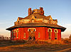 | June 21, 2021 (#100006653) | 440 Crites Rd. 39°35′07″N 82°56′31″W / 39.5854°N 82.9419°W / 39.5854; -82.9419 (Gregg-Crites Octagon House) | Circleville | |
| 15 | Horn Mound | 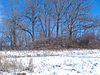 | August 7, 1974 (#74001595) | Dead end of Armstrong Road, southeast of Tarlton[9] 39°31′20″N 82°44′22″W / 39.522222°N 82.739444°W / 39.522222; -82.739444 (Horn Mound) | Salt Creek Township | Near Tarlton |
| 16 | Horsey-Barthelmas Farm |  | July 24, 1980 (#80003210) | West of Circleville on State Route 104 39°33′18″N 83°00′32″W / 39.555°N 83.008889°W / 39.555; -83.008889 (Horsey-Barthelmas Farm) | Wayne Township | |
| 17 | Lawndale Farm Complex |  | April 19, 1984 (#84003795) | 26476 Gay Dreisbach Rd., south of Circleville 39°32′49″N 82°55′10″W / 39.546944°N 82.919444°W / 39.546944; -82.919444 (Lawndale Farm Complex) | Pickaway Township | |
| 18 | Luthor List Mound | 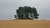 | October 16, 1974 (#74001592) | Along the Kingston Pike, southeast of Circleville[10] 39°34′31″N 82°55′29″W / 39.5753°N 82.9247°W / 39.5753; -82.9247 (Luthor List Mound) | Circleville Township | Also known as the Burning Mound[4] |
| 19 | Matthew McCrea House |  | September 29, 1988 (#88001714) | 428 E. Main St. 39°35′58″N 82°56′12″W / 39.599444°N 82.936597°W / 39.599444; -82.936597 (Matthew McCrea House) | Circleville | |
| 20 | Memorial Hall | 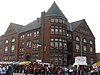 | November 21, 1980 (#80003211) | 165 E. Main St. 39°36′03″N 82°56′34″W / 39.600944°N 82.942761°W / 39.600944; -82.942761 (Memorial Hall) | Circleville | |
| 21 | Morris House |  | August 3, 1979 (#79001926) | 149 W. Union St. 39°35′58″N 82°56′56″W / 39.599306°N 82.948942°W / 39.599306; -82.948942 (Morris House) | Circleville | |
| 22 | Mount Oval |  | July 25, 1974 (#74001593) | Off U.S. Route 23, south of Circleville 39°31′42″N 82°57′59″W / 39.528333°N 82.966389°W / 39.528333; -82.966389 (Mount Oval) | Pickaway Township | |
| 23 | Ohio and Erie Canal Southern Descent Historic District | Upload image | April 1, 2019 (#100003572) | Multiple 39°42′32″N 82°58′19″W / 39.7090°N 82.9720°W / 39.7090; -82.9720 (Ohio and Erie Canal Southern Descent Historic District) | Ashville | Boundary increase approved September 2, 2022; extends into other Ohio counties |
| 24 | Perrill-Goodman Farm House | 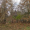 | March 14, 1985 (#85000565) | Goodman Rd., south of Groveport 39°47′18″N 82°52′56″W / 39.788333°N 82.882222°W / 39.788333; -82.882222 (Perrill-Goodman Farm House) | Madison Township | |
| 25 | Stevenson Peters House | 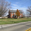 | February 9, 1984 (#84003797) | 9860 State Route 188, northeast of Circleville 39°40′29″N 82°50′17″W / 39.674722°N 82.838056°W / 39.674722; -82.838056 (Stevenson Peters House) | Walnut Township | |
| 26 | Redlands |  | May 14, 1982 (#82003630) | 1960 N. Court St., north of Circleville 39°38′06″N 82°56′31″W / 39.635°N 82.941944°W / 39.635; -82.941944 (Redlands) | Circleville Township | |
| 27 | Renick Farm | 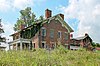 | March 5, 1982 (#82003631) | North of South Bloomfield on U.S. Route 23 39°45′01″N 82°59′28″W / 39.750278°N 82.991111°W / 39.750278; -82.991111 (Renick Farm) | Harrison Township | |
| 28 | Saint Philip's Episcopal Church |  | May 15, 1986 (#86001064) | 129 W. Mound St. 39°35′59″N 82°56′50″W / 39.599722°N 82.947222°W / 39.599722; -82.947222 (Saint Philip's Episcopal Church) | Circleville | |
| 29 | Scioto Township District No. 2 Schoolhouse | 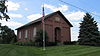 | May 6, 1987 (#87000634) | 8143 Snyder Rd., east of Orient 39°47′45″N 83°05′38″W / 39.795833°N 83.093889°W / 39.795833; -83.093889 (Scioto Township District No. 2 Schoolhouse) | Scioto Township | |
| 30 | The Shack | 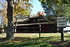 | May 23, 1974 (#74001596) | Northwest of Williamsport 39°38′07″N 83°13′47″W / 39.635278°N 83.229722°W / 39.635278; -83.229722 (The Shack) | Monroe Township | |
| 31 | Tick Ridge Mound District | 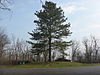 | June 11, 1975 (#75001518) | Tick Ridge Peninsula in Deer Creek State Park[11] 39°36′56″N 83°14′15″W / 39.615556°N 83.237500°W / 39.615556; -83.237500 (Tick Ridge Mound District) | Monroe Township | |
| 32 | Ansel T. Walling House |  | December 14, 1987 (#87002145) | 146 W. Union St. 39°35′58″N 82°56′55″W / 39.599444°N 82.948611°W / 39.599444; -82.948611 (Ansel T. Walling House) | Circleville | |
| 33 | Watt-Groce-Fickhardt House | 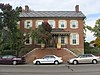 | August 23, 1985 (#85001804) | 360 E. Main St. 39°36′00″N 82°56′20″W / 39.6°N 82.938889°W / 39.6; -82.938889 (Watt-Groce-Fickhardt House) | Circleville |
See also
Wikimedia Commons has media related to National Register of Historic Places in Pickaway County, Ohio.
- List of National Historic Landmarks in Ohio
- Listings in neighboring counties: Fairfield, Fayette, Franklin, Hocking, Madison, Ross
- National Register of Historic Places listings in Ohio
References
- ^ The latitude and longitude information provided in this table was derived originally from the National Register Information System, which has been found to be fairly accurate for about 99% of listings. Some locations in this table may have been corrected to current GPS standards.
- ^ National Park Service, United States Department of the Interior, "National Register of Historic Places: Weekly List Actions", retrieved May 3, 2024.
- ^ Numbers represent an alphabetical ordering by significant words. Various colorings, defined here, differentiate National Historic Landmarks and historic districts from other NRHP buildings, structures, sites or objects.
- ^ a b "National Register Information System". National Register of Historic Places. National Park Service. April 24, 2008.
- ^ The eight-digit number below each date is the number assigned to each location in the National Register Information System database, which can be viewed by clicking the number.
- ^ "Front Cover". Ohio Archaeologist 34.2 (1984): 3.
- ^ Meeting minutes for Monday, 18 December 2006[permanent dead link], Pickaway County Commissioners, 2006. Accessed 2009-10-14.
- ^ Location derived from Mills, William C. Archeological Atlas of Ohio. Columbus: Ohio State Archeological and Historical Society, 1914, page 65 and plate 65. The NRIS lists the site as "Address Restricted".
- ^ Location derived from the parcel report from the Pickaway County Auditor's Office; the NRIS lists the site as "Address Restricted".
- ^ Location derived from its GNIS feature record; the NRIS lists the site as "Address Restricted"
- ^ "Deer Creek Park", Record Herald, 2010-08-17. Accessed 2013-03-14.
- v
- t
- e
by county
- Adams
- Allen
- Ashland
- Ashtabula
- Athens
- Auglaize
- Belmont
- Brown
- Butler
- Carroll
- Champaign
- Clark
- Clermont
- Clinton
- Columbiana
- Coshocton
- Crawford
- Cuyahoga
- Darke
- Defiance
- Delaware
- Erie
- Fairfield
- Fayette
- Franklin
- Fulton
- Gallia
- Geauga
- Greene
- Guernsey
- Hamilton
- Hancock
- Hardin
- Harrison
- Henry
- Highland
- Hocking
- Holmes
- Huron
- Jackson
- Jefferson
- Knox
- Lake
- Lawrence
- Licking
- Logan
- Lorain
- Lucas
- Madison
- Mahoning
- Marion
- Medina
- Meigs
- Mercer
- Miami
- Monroe
- Montgomery
- Morgan
- Morrow
- Muskingum
- Noble
- Ottawa
- Paulding
- Perry
- Pickaway
- Pike
- Portage
- Preble
- Putnam
- Richland
- Ross
- Sandusky
- Scioto
- Seneca
- Shelby
- Stark
- Summit
- Trumbull
- Tuscarawas
- Union
- Van Wert
- Vinton
- Warren
- Washington
- Wayne
- Williams
- Wood
- Wyandot

Municipalities and communities of Pickaway County, Ohio, United States | ||
|---|---|---|
County seat: Circleville | ||
| City |  | |
| Villages | ||
| Townships | ||
| CDPs | ||
| Unincorporated communities | ||
| Ghost town | ||
| Footnotes | ‡This populated place also has portions in an adjacent county or counties | |
| ||


