Mount Ragoona
Mountain in Tasmania, Australia


Mount Ragoona
Location of the peak in Tasmania
Mount Ragoona, sometimes Mount Rogoonga,[1] is a relatively high mountain in the southern region of the Walls of Jerusalem National Park in Tasmania, Australia. The mountain, with an elevation of 1,336 metres (4,383 ft) above sea level,[1] is virtually surrounded by four large lakes; Myrtle, Meston, Louisa and Adelaide. The mountain rises from the shores of Lake Myrtle.
Location and features
The mountain summit is at grid reference 334619 UTM Zone 55S and high resolution topographical information is available on Tasmap Cathedral (4236) 1:25000. Directly below its sheer cliff face to the immediate west is Lake Myrtle and further west lies Chalice Lake and then Cathedral Mountain, due north is Lake Bill, somewhat distant to the northeast but dominant are the Walls of Jerusalem and due south are The Mountains of Jupiter.
Nearby visible mountains include Cathedral Mountain, Mount Pelion East, Walls of Jerusalem, The Acropolis, and Mount Geryon.
On the track from Lake Myrtle to Lake Meston shown on the Cathedral Tasmap and at the approximate gridpoint 355624 UTM 55S, a poorly cairned pad follows an eastern ridge towards the summit of Mount Ragoona.
Gallery
-
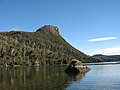 Mount Ragoona and Lake Myrtle
 -
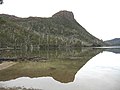 Mount Ragoona reflections
 -
 Lake Myrtle reflections
 -
 The Acropolis and Mount Geryon
 -
 Pelion West, East and Paddys Nut
 -
 Spectacular mountain views to the south-west
 -
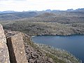
 Looking down on Lake Myrtle from near the summit


See also
 Australia portal
 Mountains portal


References
- ^ a b c "Map of Mount Rogoona, TAS". Bonzle Digital Atlas of Australia. 2017. Retrieved 30 May 2017.
- v
- t
- e
Mountains in Tasmania, Australia
| Eastern |
|
|---|
- Legges Tor (1,572 m or 5,157 ft)
- Giblin Peak (1,569 m or 5,148 ft)
- Markham Heights (1,542 m or 5,059 ft)
- Hamilton Crags (1,540 m or 5,052 ft)
- Stacks Bluff (1,527 m or 5,010 ft)
- Misery Bluff (1,520 m or 4,987 ft)
- Ossian’s Throne (1,498 m or 4,915 ft)
- Coalmine Crag (1,498 m or 4,915 ft)
- Magnet Crag (1,464 m or 4,803 ft)
- Victoria (1,213 m or 3,980 ft)
- unnamed peak (1,520 m or 4,987 ft)
- Geryon North (1,516 m or 4,974 ft)
- Massif (1,514 m or 4,967 ft)
- Geryon South (1,509 m or 4,951 ft)
- Gould (1,485 m or 4,872 ft)
- Castle Crag (1,482 m or 4,862 ft)
- Thetis (1,482 m or 4,862 ft)
- The Acropolis (1,481 m or 4,859 ft)
- Achilles (1,363 m or 4,472 ft)
- Eldon Peak (1,440 m or 4,724 ft)
- Eldon Bluff
- Ironstone (1,443 m or 4,734 ft)
- Ossa (1,614 m or 5,295 ft)1
- Pelion West (1,560 m or 5,118 ft)
- Pelion East (1,461 m or 4,793 ft)
- Kunanyi / Wellington (1,269 m or 4,163 ft)
- Murchison (1,275 m or 4,183 ft)
- Jukes (1,168 m or 3,832 ft)
- Sedgwick (1,147 m or 3,763 ft)
- Owen (1,146 m or 3,760 ft)
- Sorell (1,144 m or 3,753 ft)
- Read (1,124 m or 3,688 ft)
- Proprietary Peak (1,103 m or 3,619 ft)
- Hamilton (1,103 m or 3,619 ft)
- Darwin (1,031 m or 3,383 ft)
| Heemskirk | |
|---|---|
| Sticht |
|
| Tyndall |
|
- Mount Olympus (1,472 m or 4,829 ft)
- Frenchmans Cap (1,446 m or 4,744 ft)
- Barrow (1,406 m or 4,613 ft)
1 Highest summit elevation in Tasmania
 Category
 Category


