Ironstone Mountain
Mountain in Tasmania, Australia


Ironstone Mountain
Location in Tasmania
The Ironstone Mountain is a mountain located in the Central Highlands region of Tasmania, Australia. Part of Great Western Tiers escarpment, the mountain is situated south of the small country village of Mole Creek.
With an elevation of 1,444 metres (4,738 ft) above sea level,[1] the mountain is the highest peak of the Great Western Tiers[2] and has a nearby companion lake, Lake Ironstone. The highest point is marked with a trig point, but more dominant is the slightly lower part of the mountain depicted here in the information box.
Location and access
The mountain is at grid reference 563819 UTM Zone 55S (Universal Transverse Mercator coordinate system) and high resolution topographical information is available on Tasmap Lake Mackenzie (4438) 1:25000.
Access to Ironstone Mountain is mainly from two walking tracks. The closest access is from the north via Mole Creek, Caveside and Westrope Road to the Western Creek Track which follows the eastern side of the gully formed by Western Creek. Another access route is from the east via Deloraine, Meander, Smoko Road and the Mount Ironstone Track. This track starts 2 kilometres (1.2 mi) south of Mother Cummings Peak, another dominant landmark in the region.
-
 Lake Ironstone
 -
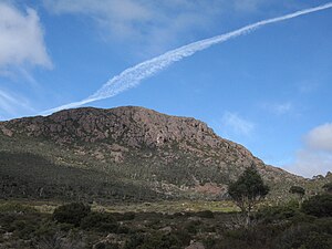 Jet trail over Ironstone
 -
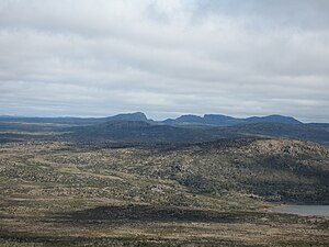 The Walls of Jerusalem from Ironstone


See also
 Australia portal
 Mountains portal


References
- ^ a b c "Ironstone Mountain, Australia". Peakbagger.com. Retrieved 31 May 2017.
- ^ a b Lloyd, Sarah (2012). The edge, a natural history of Tasmania's Great Western Tiers. Friends of Jacky's Marsh Inc. p. 1. ISBN 978-0-646-57082-2.
- ^ "Ironstone Mountain (TAS)". Gazetteer of Australia online. Geoscience Australia, Australian Government.
External links
- [1]
- v
- t
- e
Mountains in Tasmania, Australia
| Eastern |
|
|---|
- Legges Tor (1,572 m or 5,157 ft)
- Giblin Peak (1,569 m or 5,148 ft)
- Markham Heights (1,542 m or 5,059 ft)
- Hamilton Crags (1,540 m or 5,052 ft)
- Stacks Bluff (1,527 m or 5,010 ft)
- Misery Bluff (1,520 m or 4,987 ft)
- Ossian’s Throne (1,498 m or 4,915 ft)
- Coalmine Crag (1,498 m or 4,915 ft)
- Magnet Crag (1,464 m or 4,803 ft)
- Victoria (1,213 m or 3,980 ft)
- unnamed peak (1,520 m or 4,987 ft)
- Geryon North (1,516 m or 4,974 ft)
- Massif (1,514 m or 4,967 ft)
- Geryon South (1,509 m or 4,951 ft)
- Gould (1,485 m or 4,872 ft)
- Castle Crag (1,482 m or 4,862 ft)
- Thetis (1,482 m or 4,862 ft)
- The Acropolis (1,481 m or 4,859 ft)
- Achilles (1,363 m or 4,472 ft)
- Eldon Peak (1,440 m or 4,724 ft)
- Eldon Bluff
- Ironstone (1,443 m or 4,734 ft)
- Ossa (1,614 m or 5,295 ft)1
- Pelion West (1,560 m or 5,118 ft)
- Pelion East (1,461 m or 4,793 ft)
- Kunanyi / Wellington (1,269 m or 4,163 ft)
- Murchison (1,275 m or 4,183 ft)
- Jukes (1,168 m or 3,832 ft)
- Sedgwick (1,147 m or 3,763 ft)
- Owen (1,146 m or 3,760 ft)
- Sorell (1,144 m or 3,753 ft)
- Read (1,124 m or 3,688 ft)
- Proprietary Peak (1,103 m or 3,619 ft)
- Hamilton (1,103 m or 3,619 ft)
- Darwin (1,031 m or 3,383 ft)
| Heemskirk | |
|---|---|
| Sticht |
|
| Tyndall |
|
- Mount Olympus (1,472 m or 4,829 ft)
- Frenchmans Cap (1,446 m or 4,744 ft)
- Barrow (1,406 m or 4,613 ft)
1 Highest summit elevation in Tasmania
 Category
 Category


