Lavras do Sul
Municipality in Rio Grande do Sul, Brazil

Flag

Coat of arms
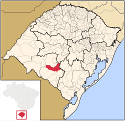
Location in Rio Grande do Sul state
 Brazil
 (2020 [1])
97390-xxx
Lavras do Sul is a Brazilian municipality in the southwestern part of the state of Rio Grande do Sul. It is in the Campanha Meridional micro-region and the Sudoeste Rio-Grandense meso-region. The population is 7,444 (2020 est.) in an area of 2600.60 km².[2] The Camaquã River flows through the municipality.
Bounding municipalities
- Bagé
- Dom Pedrito
- Caçapava do Sul
- São Gabriel
References
External links
- http://www.citybrazil.com.br/rs/lavrasdosul/ (in Portuguese)
Wikimedia Commons has media related to Lavras do Sul.
- v
- t
- e

Capital: Porto Alegre
Mesoregion Centro Ocidental Rio-Grandense | |||||||
|---|---|---|---|---|---|---|---|
| |||||||

Mesoregion Metropolitana de Porto Alegre | |||||||||||||
|---|---|---|---|---|---|---|---|---|---|---|---|---|---|
| |||||||||||||
Mesoregion Nordeste Rio-Grandense | |||||||
|---|---|---|---|---|---|---|---|
| |||||||
Mesoregion Noroeste Rio-Grandense | |||||||||||||||||||||||||||
|---|---|---|---|---|---|---|---|---|---|---|---|---|---|---|---|---|---|---|---|---|---|---|---|---|---|---|---|
| |||||||||||||||||||||||||||
Mesoregion Sudeste Rio-Grandense | |||||||||
|---|---|---|---|---|---|---|---|---|---|
| |||||||||
Mesoregion Sudoeste Rio-Grandense | |||||||
|---|---|---|---|---|---|---|---|
| |||||||
Authority control databases | |
|---|---|
| International |
|
| National |
|


