Laruns
You can help expand this article with text translated from the corresponding article in French. (December 2008) Click [show] for important translation instructions.
- View a machine-translated version of the French article.
- Machine translation, like DeepL or Google Translate, is a useful starting point for translations, but translators must revise errors as necessary and confirm that the translation is accurate, rather than simply copy-pasting machine-translated text into the English Wikipedia.
- Do not translate text that appears unreliable or low-quality. If possible, verify the text with references provided in the foreign-language article.
- You must provide copyright attribution in the edit summary accompanying your translation by providing an interlanguage link to the source of your translation. A model attribution edit summary is
Content in this edit is translated from the existing French Wikipedia article at [[:fr:Laruns]]; see its history for attribution. - You may also add the template
{{Translated|fr|Laruns}}to the talk page. - For more guidance, see Wikipedia:Translation.
Commune in Nouvelle-Aquitaine, France

Coat of arms
Location of Laruns

(2020–2026) Robert Casadebaig[1]
1
(2021)[2]
64320 /64440
(avg. 536 m or 1,759 ft)
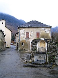
Laruns (French pronunciation: [laʁœ̃s];[3][4][5] Occitan: Laruntz) is a commune in the Pyrénées-Atlantiques department in south-western France.[6]
It is situated at the confluence of two mountain streams, the Gave d'Ossau and its tributary, the Valentin.[7]
Formerly part of the province of Béarn, Laruns is now within the département of Pyrénées-Atlantiques, itself in France's Nouvelle-Aquitaine région. It forms part of the arrondissement of Oloron-Sainte-Marie, and of the canton of Oloron-Sainte-Marie-2.[6]
Geography
Laruns is geographically the third-largest commune in metropolitan France, after Arles and Saintes-Maries-de-la-Mer. It includes a large area of upland, around and between the Gave d'Ossau and its tributaries, stretching as far as the border with Spain at the Col du Pourtalet, 30 km (19 mi) to the south of the village of Laruns.
The principal artery of communications through the commune is the D934 road, which runs south from the town of Pau, 40 km (25 mi) to the north, to the Col du Pourtalet. The D918 road branches off the D934 in Laruns village, and follows the Valentin before crossing the Col d'Aubisque to Argelès-Gazost in the next major valley to the east. There are no direct roads westward from Laruns.
Because of its large geographic size, the Laruns contains several recognisably distinct communities in addition to Laruns itself. These include:[8]
- Pon, an area of Laruns
- Espalungue, an area of Laruns
- Gêtre, an area of Laruns
- Gabas, a hamlet below the Pic du Midi d'Ossau, and where the valley road is crossed by the GR10 long-distance footpath that runs the length of the Pyrenees
- Geteu, a former commune merged into Laruns in 1828
- Goust, on a small plateau above Laruns
- Eaux-Chaudes, a spa situated at the southern entrance to the Gorge du Hourat
- Artouste-Fabrèges, a ski resort situated in the valley of the Gave du Brousset, and the beginning of the summer scenic route to the Lac d'Artouste via the Petit train d'Artouste
- Miegebat
Neighboring communes and municipalities:
- North: Gère-Bélesten and Aste-Béon
- East: Arrens-Marsous (Hautes-Pyrénées), Louvie-Soubiron, Béost and Eaux-Bonnes
- West: Aydius, Bedous, Cette-Eygun, Etsaut and Urdos
- South: Sallent de Gállego (Huesca, Spain).
See also
References
- ^ "Répertoire national des élus: les maires" (in French). data.gouv.fr, Plateforme ouverte des données publiques françaises. 13 September 2022.
- ^ "Populations légales 2021". The National Institute of Statistics and Economic Studies. 28 December 2023.
- ^ France 3 Nouvelle-Aquitaine. "" Tous les chemins mènent à vous " à Laruns dans les Pyrénées-Atlantiques". YouTube.
{{cite web}}: CS1 maint: numeric names: authors list (link) - ^ France 3 Nouvelle-Aquitaine. "Fêtes de Laruns 2019". YouTube.
{{cite web}}: CS1 maint: numeric names: authors list (link) - ^ France 3 Nouvelle-Aquitaine. "Laruns attend son tour de France avec impatience". YouTube.
{{cite web}}: CS1 maint: numeric names: authors list (link) - ^ a b INSEE commune file
- ^ Reynolds, Kev (2004). The Pyrenees: The High Pyrenees from the Cirque De Lescun to the Carlit Massif. Cicerone Press. p. 132. ISBN 1-85284-420-5.
- ^ The villages of the city of Laruns
External links
Wikimedia Commons has media related to Laruns.
- Laruns website
- Laruns website Archived 2007-07-29 at the Wayback Machine
- v
- t
- e

- Aast
- Abère
- Abidos
- Abitain
- Abos
- Accous
- Agnos
- Ahaxe-Alciette-Bascassan
- Ahetze
- Aïcirits-Camou-Suhast
- Aincille
- Ainharp
- Ainhice-Mongelos
- Ainhoa
- Alçay-Alçabéhéty-Sunharette
- Aldudes
- Alos-Sibas-Abense
- Amendeuix-Oneix
- Amorots-Succos
- Ance Féas
- Andoins
- Andrein
- Angaïs
- Anglet
- Angous
- Anhaux
- Anos
- Anoye
- Aramits
- Arancou
- Araujuzon
- Araux
- Arbérats-Sillègue
- Arbonne
- Arbouet-Sussaute
- Arbus
- Arcangues
- Aren
- Aressy
- Arette
- Argagnon
- Argelos
- Arget
- Arhansus
- Armendarits
- Arnéguy
- Arnos
- Aroue-Ithorots-Olhaïby
- Arrast-Larrebieu
- Arraute-Charritte
- Arricau-Bordes
- Arrien
- Arros-de-Nay
- Arrosès
- Arthez-d'Asson
- Arthez-de-Béarn
- Artigueloutan
- Artiguelouve
- Artix
- Arudy
- Arzacq-Arraziguet
- Asasp-Arros
- Ascain
- Ascarat
- Assat
- Asson
- Aste-Béon
- Astis
- Athos-Aspis
- Aubertin
- Aubin
- Aubous
- Audaux
- Auga
- Auriac
- Aurions-Idernes
- Aussevielle
- Aussurucq
- Auterrive
- Autevielle-Saint-Martin-Bideren
- Aydie
- Aydius
- Ayherre
- Baigts-de-Béarn
- Balansun
- Baleix
- Baliracq-Maumusson
- Baliros
- Banca
- Barcus
- Bardos
- Barinque
- Barraute-Camu
- Barzun
- Bassillon-Vauzé
- Bassussarry
- Bastanès
- La Bastide-Clairence
- Baudreix
- Bayonnesubpr
- Bédeille
- Bedous
- Béguios
- Béhasque-Lapiste
- Béhorléguy
- Bellocq
- Bénéjacq
- Bentayou-Sérée
- Béost
- Bérenx
- Bergouey-Viellenave
- Bernadets
- Berrogain-Laruns
- Bescat
- Bésingrand
- Bétracq
- Beuste
- Beyrie-en-Béarn
- Beyrie-sur-Joyeuse
- Biarritz
- Bidache
- Bidarray
- Bidart
- Bidos
- Bielle
- Bilhères
- Billère
- Biriatou
- Biron
- Bizanos
- Boeil-Bezing
- Bonloc
- Bonnut
- Borce
- Bordères
- Bordes
- Bosdarros
- Boucau
- Boueilh-Boueilho-Lasque
- Bougarber
- Bouillon
- Boumourt
- Bourdettes
- Bournos
- Briscous
- Bruges-Capbis-Mifaget
- Bugnein
- Bunus
- Burgaronne
- Buros
- Burosse-Mendousse
- Bussunarits-Sarrasquette
- Bustince-Iriberry
- Buziet
- Buzy
- Cabidos
- Cadillon
- Cambo-les-Bains
- Came
- Camou-Cihigue
- Cardesse
- Çaro
- Carrère
- Carresse-Cassaber
- Castagnède
- Casteide-Cami
- Casteide-Candau
- Casteide-Doat
- Castéra-Loubix
- Castet
- Castetbon
- Castétis
- Castetnau-Camblong
- Castetner
- Castetpugon
- Castillon-d'Arthez
- Castillon-de-Lembeye
- Caubios-Loos
- Cescau
- Cette-Eygun
- Charre
- Charritte-de-Bas
- Chéraute
- Ciboure
- Claracq
- Coarraze
- Conchez-de-Béarn
- Corbère-Abères
- Coslédaà-Lube-Boast
- Coublucq
- Crouseilles
- Cuqueron
- Denguin
- Diusse
- Doazon
- Dognen
- Domezain-Berraute
- Doumy
- Eaux-Bonnes
- Escos
- Escot
- Escou
- Escoubès
- Escout
- Escurès
- Eslourenties-Daban
- Espéchède
- Espelette
- Espès-Undurein
- Espiute
- Espoey
- Esquiule
- Estérençuby
- Estialescq
- Estos
- Etcharry
- Etchebar
- Etsaut
- Eysus
- Fichous-Riumayou
- Gabaston
- Gabat
- Gamarthe
- Gan
- Garindein
- Garlède-Mondebat
- Garlin
- Garos
- Garris
- Gayon
- Gelos
- Ger
- Gerderest
- Gère-Bélesten
- Géronce
- Gestas
- Géus-d'Arzacq
- Geüs-d'Oloron
- Goès
- Gomer
- Gotein-Libarrenx
- Guéthary
- Guiche
- Guinarthe-Parenties
- Gurmençon
- Gurs
- Hagetaubin
- Halsou
- Hasparren
- Haut-de-Bosdarros
- Haux
- Hélette
- Hendaye
- Herrère
- Higuères-Souye
- L'Hôpital-d'Orion
- L'Hôpital-Saint-Blaise
- Hosta
- Hours
- Ibarrolle
- Idaux-Mendy
- Idron
- Igon
- Iholdy
- Ilharre
- Irissarry
- Irouléguy
- Ispoure
- Issor
- Isturits
- Itxassou
- Izeste
- Jasses
- Jatxou
- Jaxu
- Jurançon
- Juxue
- Laà-Mondrans
- Laàs
- Labastide-Cézéracq
- Labastide-Monréjeau
- Labastide-Villefranche
- Labatmale
- Labatut-Figuières
- Labets-Biscay
- Labeyrie
- Lacadée
- Lacarre
- Lacarry-Arhan-Charritte-de-Haut
- Lacommande
- Lacq
- Lagor
- Lagos
- Laguinge-Restoue
- Lahonce
- Lahontan
- Lahourcade
- Lalongue
- Lalonquette
- Lamayou
- Lanne-en-Barétous
- Lannecaube
- Lanneplaà
- Lantabat
- Larceveau-Arros-Cibits
- Laroin
- Larrau
- Larressore
- Larreule
- Larribar-Sorhapuru
- Laruns
- Lasclaveries
- Lasse
- Lasserre
- Lasseube
- Lasseubetat
- Lay-Lamidou
- Lecumberry
- Ledeuix
- Lée
- Lées-Athas
- Lembeye
- Lème
- Léren
- Lescar
- Lescun
- Lespielle
- Lespourcy
- Lestelle-Bétharram
- Lichans-Sunhar
- Lichos
- Licq-Athérey
- Limendous
- Livron
- Lohitzun-Oyhercq
- Lombia
- Lonçon
- Lons
- Loubieng
- Louhossoa
- Lourdios-Ichère
- Lourenties
- Louvie-Juzon
- Louvie-Soubiron
- Louvigny
- Luc-Armau
- Lucarré
- Lucgarier
- Lucq-de-Béarn
- Lurbe-Saint-Christau
- Lussagnet-Lusson
- Luxe-Sumberraute
- Lys
- Macaye
- Malaussanne
- Mascaraàs-Haron
- Maslacq
- Masparraute
- Maspie-Lalonquère-Juillacq
- Maucor
- Mauléon-Licharre
- Maure
- Mazères-Lezons
- Mazerolles
- Méharin
- Meillon
- Mendionde
- Menditte
- Mendive
- Méracq
- Méritein
- Mesplède
- Mialos
- Miossens-Lanusse
- Mirepeix
- Momas
- Momy
- Monassut-Audiracq
- Moncaup
- Moncayolle-Larrory-Mendibieu
- Moncla
- Monein
- Monpezat
- Monségur
- Mont
- Montagut
- Montaner
- Montardon
- Montaut
- Mont-Disse
- Montfort
- Montory
- Morlaàs
- Morlanne
- Mouguerre
- Mouhous
- Moumour
- Mourenx
- Musculdy
- Nabas
- Narcastet
- Narp
- Navailles-Angos
- Navarrenx
- Nay
- Noguères
- Nousty
- Ogenne-Camptort
- Ogeu-les-Bains
- Oloron-Sainte-Mariesubpr
- Oraàs
- Ordiarp
- Orègue
- Orin
- Orion
- Orriule
- Orsanco
- Orthez
- Os-Marsillon
- Ossas-Suhare
- Osse-en-Aspe
- Ossenx
- Osserain-Rivareyte
- Ossès
- Ostabat-Asme
- Ouillon
- Ousse
- Ozenx-Montestrucq
- Pagolle
- Parbayse
- Pardies
- Pardies-Piétat
- Paupref
- Peyrelongue-Abos
- Piets-Plasence-Moustrou
- Poey-de-Lescar
- Poey-d'Oloron
- Pomps
- Ponson-Debat-Pouts
- Ponson-Dessus
- Pontacq
- Pontiacq-Viellepinte
- Portet
- Pouliacq
- Poursiugues-Boucoue
- Préchacq-Josbaig
- Préchacq-Navarrenx
- Précilhon
- Puyoô
- Ramous
- Rébénacq
- Ribarrouy
- Riupeyrous
- Rivehaute
- Rontignon
- Roquiague
- Saint-Abit
- Saint-Armou
- Saint-Boès
- Saint-Castin
- Saint-Dos
- Sainte-Colome
- Sainte-Engrâce
- Saint-Esteben
- Saint-Étienne-de-Baïgorry
- Saint-Faust
- Saint-Girons-en-Béarn
- Saint-Gladie-Arrive-Munein
- Saint-Goin
- Saint-Jammes
- Saint-Jean-de-Luz
- Saint-Jean-le-Vieux
- Saint-Jean-Pied-de-Port
- Saint-Jean-Poudge
- Saint-Just-Ibarre
- Saint-Laurent-Bretagne
- Saint-Martin-d'Arberoue
- Saint-Martin-d'Arrossa
- Saint-Médard
- Saint-Michel
- Saint-Palais
- Saint-Pé-de-Léren
- Saint-Pée-sur-Nivelle
- Saint-Pierre-d'Irube
- Saint-Vincent
- Salies-de-Béarn
- Salles-Mongiscard
- Sallespisse
- Sames
- Samsons-Lion
- Sare
- Sarpourenx
- Sarrance
- Saubole
- Saucède
- Sauguis-Saint-Étienne
- Sault-de-Navailles
- Sauvagnon
- Sauvelade
- Sauveterre-de-Béarn
- Séby
- Sedze-Maubecq
- Sedzère
- Séméacq-Blachon
- Sendets
- Serres-Castet
- Serres-Morlaàs
- Serres-Sainte-Marie
- Sévignacq
- Sévignacq-Meyracq
- Simacourbe
- Siros
- Soumoulou
- Souraïde
- Suhescun
- Sus
- Susmiou
- Tabaille-Usquain
- Tadousse-Ussau
- Tardets-Sorholus
- Taron-Sadirac-Viellenave
- Tarsacq
- Thèze
- Trois-Villes
- Uhart-Cize
- Uhart-Mixe
- Urcuit
- Urdos
- Urepel
- Urost
- Urrugne
- Urt
- Ustaritz
- Uzan
- Uzein
- Uzos
- Verdets
- Vialer
- Viellenave-d'Arthez
- Viellenave-de-Navarrenx
- Vielleségure
- Vignes
- Villefranque
- Viodos-Abense-de-Bas
- Viven
- pref: prefecture
- subpr: subprefecture
Authority control databases | |
|---|---|
| International |
|
| National |
|
| Geographic |
|


