Kunfehértó
You can help expand this article with text translated from the corresponding article in Hungarian. (January 2024) Click [show] for important translation instructions.
- Machine translation, like DeepL or Google Translate, is a useful starting point for translations, but translators must revise errors as necessary and confirm that the translation is accurate, rather than simply copy-pasting machine-translated text into the English Wikipedia.
- Consider adding a topic to this template: there are already 591 articles in the main category, and specifying
|topic=will aid in categorization. - Do not translate text that appears unreliable or low-quality. If possible, verify the text with references provided in the foreign-language article.
- You must provide copyright attribution in the edit summary accompanying your translation by providing an interlanguage link to the source of your translation. A model attribution edit summary is
Content in this edit is translated from the existing Hungarian Wikipedia article at [[:hu:Kunfehértó]]; see its history for attribution. - You may also add the template
{{Translated|hu|Kunfehértó}}to the talk page. - For more guidance, see Wikipedia:Translation.
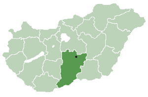
Place in Bács-Kiskun, Hungary

Flag

Coat of arms
 Hungary
 (2005)
641
Kunfehértó is a village in Bács-Kiskun county, in the Southern Great Plain region of Hungary. In near the village there is a holiday village. Due to its small size, there is only one main road to enter the village. By following this about 2 km through the village, one will arrive at the other end where several new homes have been built the last years. A few hundred metres further one will come to an area of summer holiday cottages. Here one will also find a small lake, which in Hungarian is called tó.
Many people in the village makes a living from farming, hand craft or other entrepreneurial businesses, while knowledge intensive occupations such as doctors and lawyers are more typical in the bigger villages or cities.
Croats in Hungary call this village Fertov and Vertov.[1]
History
It was not before 1948 that the idea of building the village came up. Before this there was only an elementary school and the train station for the people living in the area. The location where the village is situated today was basically made up of puszta and grazing fields. In 1950 the area was measured into land lot(s), and it was on these parcels of land that the village was built. In 1951 the name Bácsfehértó was given to the village, but this was changed to Kunfehértó in 1952, the same year as electricity was integrated in the village. In the first period, between 1950 and 1953, around 180-190 homes were built. In the following years public buildings such as the town hall, kinder garden and post office were built.
The area around the lake with all the summer cottages was until recently a popular summer holiday destination for many German, Dutch and Austrian tourists, but the last ten years, after the increasing popularity of Lake Balaton and other bigger places in Hungary, these visitors are almost absent today. Still, the yearly beer festival with its concerts, parties and entertainment attracts a great number of visitors from all over the county and Hungary. Also, every summer many children spends a week or two in summer camps or at the sports facilities near the lake.
Geography
It covers an area of 78.37 km2 (30 sq mi) and has a population of 2307 people (2005). The village is located between the two cities Kiskunhalas and Jánoshalma, about 50 km from the Serbian border.
References
- ^ "Folia onomastica croatica 14/2005". (462 KB) Živko Mandić: Hrvatska imena naseljenih mjesta u Madžarskoj,
External links
- Official website
- v
- t
- e
- Kecskemét (county seat)


- Ágasegyháza
- Akasztó
- Apostag
- Bácsborsód
- Bácsszentgyörgy
- Bácsszőlős
- Ballószög
- Balotaszállás
- Bátmonostor
- Bátya
- Bócsa
- Borota
- Bugacpusztaháza
- Császártöltés
- Csátalja
- Csávoly
- Csengőd
- Csikéria
- Csólyospálos
- Dávod
- Drágszél
- Dunaegyháza
- Dunafalva
- Dunaszentbenedek
- Dunatetétlen
- Dusnok
- Érsekcsanád
- Érsekhalma
- Fajsz
- Felsőlajos
- Felsőszentiván
- Foktő
- Fülöpháza
- Fülöpjakab
- Fülöpszállás
- Gara
- Gátér
- Géderlak
- Harkakötöny
- Helvécia
- Hercegszántó
- Homokmégy
- Imrehegy
- Jakabszállás
- Jászszentlászló
- Kaskantyú
- Katymár
- Kelebia
- Kéleshalom
- Kisszállás
- Kömpöc
- Kunadacs
- Kunbaja
- Kunbaracs
- Kunfehértó
- Kunpeszér
- Kunszállás
- Ladánybene
- Madaras
- Mátételke
- Miske
- Móricgát
- Nagybaracska
- Nemesnádudvar
- Nyárlőrinc
- Ordas
- Öregcsertő
- Orgovány
- Páhi
- Pálmonostora
- Petőfiszállás
- Pirtó
- Rém
- Soltszentimre
- Szakmár
- Szalkszentmárton
- Szank
- Szentkirály
- Szeremle
- Tabdi
- Tass
- Tataháza
- Tázlár
- Tiszaug
- Újsolt
- Újtelek
- Uszód
- Városföld
- Vaskút
- Zsana
46°21′32″N 19°24′58″E / 46.35889°N 19.41611°E / 46.35889; 19.41611


