Irakleia, Serres
Municipality in Greece
Irakleia Ηράκλεια | |
|---|---|
 | |
| 41°11′N 23°17′E / 41.183°N 23.283°E / 41.183; 23.283 | |
| Country | Greece |
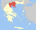
| Administrative region | Central Macedonia |
| Regional unit | Serres |
| Government | |
| • Mayor | Kleanthis Kotsakiachidis[1] (since 2023) |
| Area | |
| • Municipality | 451.5 km2 (174.3 sq mi) |
| • Municipal unit | 195.2 km2 (75.4 sq mi) |
| Population (2021)[2] | |
| • Municipality | 15,713 |
| • Density | 35/km2 (90/sq mi) |
| • Municipal unit | 9,946 |
| • Municipal unit density | 51/km2 (130/sq mi) |
| • Community | 3,245 |
| Time zone | UTC+2 (EET) |
| • Summer (DST) | UTC+3 (EEST) |
| Vehicle registration | ΕΡ |
| Website | www.dimosiraklias.gr |
Irakleia (Greek: Ηράκλεια, before 1926: Τζουμαγιά - Tzoumagia[3]) is a municipality in the Serres regional unit, Central Macedonia, Greece. Population 21,145 (2011). The seat of the municipality is the town of Irakleia, which was formerly known as "Lower Jumaya" (in Turkish: Barakli Cuma or Cuma-i Zir ("Lower Juma" in Ottoman Turkish); in Bulgarian: Долна Джумая, Dolna Dzhumaya;[4][5] and in Aromanian: Giumaia di-Nghios).[6] "Upper Dzhumaya" is modern Blagoevgrad, located in Bulgaria.[citation needed] In the Serres area, during Ottoman times, Aromanians settled in modern Irakleia. Some Aromanians still live in the city today, with Bulgarian researcher Vasil Kanchov even saying that, as of when he visited the town, the 1250 Aromanians in Irakleia "were the wealthiest of all inhabitants".[6]
Municipality
The municipality Irakleia was formed at the 2011 local government reform by the merger of the following 3 former municipalities, that became municipal units:[7]
- Irakleia
- Skotoussa
- Strymoniko
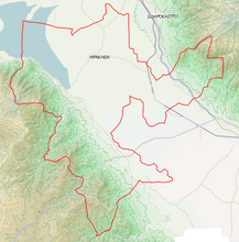
The municipality has an area of 451.499 km2, the municipal unit 195.216 km2.[8] The municipal unit of Irakleia consists of the communities Chrysochorafa, Dasochori, Irakleia, Karperi, Koimisi, Limnochori, Lithotopos, Pontismeno and Valtero.[7]
References
- ^ Municipality of Iraklia, Municipal elections – October 2023, Ministry of Interior
- ^ "Αποτελέσματα Απογραφής Πληθυσμού - Κατοικιών 2021, Μόνιμος Πληθυσμός κατά οικισμό" [Results of the 2021 Population - Housing Census, Permanent population by settlement] (in Greek). Hellenic Statistical Authority. 29 March 2024.
- ^ Name changes of settlements in Greece
- ^ D.M.Brancoff. "La Macédoine et sa Population Chrétienne". Paris, 1905, p.104, under the name of Barakli Djoumaia
- ^ Ιστορία του Ελληνικού Έθνους. Εκδοτική Αθηνών, Αθήνα 1978. ISBN 960-213-110-1, σελ. 228-229; Map of the Italian Instituto Geografico de Agostini, showing the distribution of schools, churches, monasteries in the Ottoman vilayet of Saloniki
- ^ a b The War of Numbers and its First Victim: The Aromanians in Macedonia (End of 19th – Beginning of 20th century)
- ^ a b "ΦΕΚ A 87/2010, Kallikratis reform law text" (in Greek). Government Gazette.
- ^ "Population & housing census 2001 (incl. area and average elevation)" (PDF) (in Greek). National Statistical Service of Greece. Archived from the original (PDF) on 2015-09-21.
External links
- Official website of the Municipality of Irakleia
- v
- t
- e
Administrative division of the Central Macedonia Region
- Area
- 18,811 km2 (7,263 sq mi)
- Population
- 1,882,108 (as of 2011)
- Municipalities
- 38 (since 2011)
- Capital
- Thessaloniki
- Aristotelis
- Kassandra
- Nea Propontida
- Polygyros
- Sithonia
- Kilkis
- Paionia
- Amfipoli
- Emmanouil Pappas
- Irakleia
- Nea Zichni
- Serres
- Sintiki
- Visaltia
- Regional governor
- Apostolos Tzitzikostas (since 2013, elected 2014 & 2019)
- Decentralized Administration
- Macedonia and Thrace
 | This Central Macedonia location article is a stub. You can help Wikipedia by expanding it. |
- v
- t
- e


