Grade I and II* listed buildings in the London Borough of Bromley
Map all coordinates using OpenStreetMap
Download coordinates as:
- KML
- GPX (all coordinates)
- GPX (primary coordinates)
- GPX (secondary coordinates)
There are over 9,000 Grade I listed buildings and 20,000 Grade II* listed buildings in England. This page is a list of these buildings in the London Borough of Bromley.
Grade I
| Name | Location | Type | Completed [note 1] | Date designated | Grid ref.[note 2] Geo-coordinates | Entry number [note 3] | Image |
|---|---|---|---|---|---|---|---|
| Bromley College | Bromley | House | 1666 | 10 January 1955 | TQ4002269573 51°24′28″N 0°00′43″E / 51.407902°N 0.011826°E / 51.407902; 0.011826 (Bromley College) | 1359324 |  More images |
| Gateway at Bromley College | Bromley | Gate | 1665 | 10 January 1955 | TQ3999769565 51°24′28″N 0°00′41″E / 51.407836°N 0.011464°E / 51.407836; 0.011464 (Gateway at Bromley College) | 1064374 |  More images |
| Down House | Downe | House | Early 19th century | 31 May 1954 | TQ4315461150 51°19′53″N 0°03′12″E / 51.331433°N 0.053438°E / 51.331433; 0.053438 (Down House) | 1038325 |  More images |
| Holwood House | Keston | Country house | 1825 | 10 January 1955 | TQ4224263549 51°21′12″N 0°02′29″E / 51.353219°N 0.041313°E / 51.353219; 0.041313 (Holwood House) | 1281097 |  More images |
| Keston Windmill | Keston | Windmill | 1716 | 10 January 1955 | TQ4154564028 51°21′28″N 0°01′53″E / 51.357697°N 0.031501°E / 51.357697; 0.031501 (Keston Windmill) | 1064369 |  More images |
| Prehistoric animal sculptures, geological formations & lead mine† | Penge/Beckenham | Statue | 1852–55 | 29 June 1973 | TQ3448770522 51°25′04″N 0°04′02″W / 51.417769°N 0.067346°W / 51.417769; -0.067346 (Prehistoric animal sculptures, geological formations & lead mine†) | 1067798 |  More images |
| Sundridge Park | Bromley | Country house | Early 18th century | 10 January 1955 | TQ4179170634 51°25′01″N 0°02′16″E / 51.416997°N 0.037667°E / 51.416997; 0.037667 (Sundridge Park) | 1299044 | 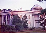 More images |
| Wickham Court | Beckenham | Courtyard house | Reign of Edward IV | 28 May 1954 | TQ3899164756 51°21′54″N 0°00′18″W / 51.364869°N 0.004871°W / 51.364869; -0.004871 (Wickham Court) | 1055809 |  More images |
- † on Islands and on land facing the Lower Lake
Grade II*
| Name | Location | Type | Completed [note 1] | Date designated | Grid ref.[note 2] Geo-coordinates | Entry number [note 3] | Image |
|---|---|---|---|---|---|---|---|
| Bromley War Memorial, St Martin's Hill | Bromley | War memorial | 1922 | 14 December 1995 | TQ3997969238 51°24′18″N 0°00′40″E / 51.404902°N 0.011076°E / 51.404902; 0.011076 (Bromley War Memorial, St Martin's Hill) | 1116976 |  More images |
| Bullers Wood | Chislehurst | House | 1889 | 29 June 1973 | TQ4243469770 51°24′33″N 0°02′48″E / 51.409072°N 0.046561°E / 51.409072; 0.046561 (Bullers Wood) | 1204400 |  More images |
| Camden Place | Chislehurst | House | 1609–23 | 25 August 1954 | TQ4374170042 51°24′40″N 0°03′56″E / 51.411187°N 0.065451°E / 51.411187; 0.065451 (Camden Place) | 1064325 |  More images |
| Chesil House | Chislehurst | House | 18th century | 25 August 1954 | TQ4458669981 51°24′38″N 0°04′39″E / 51.410424°N 0.077567°E / 51.410424; 0.077567 (Chesil House) | 1299045 |  More images |
| Church of All Saints | Orpington | Church | 14th century | 31 May 1954 | TQ4666166413 51°22′40″N 0°06′21″E / 51.377831°N 0.105909°E / 51.377831; 0.105909 (Church of All Saints) | 1083559 |  More images |
| Church of St Giles the Abbot | Farnborough | Church | 1640 | 31 May 1954 | TQ4438164125 51°21′28″N 0°04′20″E / 51.357856°N 0.072243°E / 51.357856; 0.072243 (Church of St Giles the Abbot) | 1064339 |  More images |
| Church of St John the Baptist | West Wickham | Church | Late 15th century | 28 May 1954 | TQ3889864854 51°21′57″N 0°00′22″W / 51.365772°N 0.006168°W / 51.365772; -0.006168 (Church of St John the Baptist) | 1359332 |  More images |
| Lych-gate to Church of St John the Baptist's Churchyard | West Wickham | Lych gate | 15th century or early 16th century | 28 May 1954 | TQ3893964849 51°21′57″N 0°00′20″W / 51.365717°N 0.005581°W / 51.365717; -0.005581 (Lych-gate to Church of St John the Baptist's Churchyard) | 1064391 |  More images |
| Church of St Martin of Tours | Bromley | Church | 1857 | 31 May 1954 | TQ4796064002 51°21′21″N 0°07′25″E / 51.35583°N 0.123557°E / 51.35583; 0.123557 (Church of St Martin of Tours) | 1084343 |  More images |
| Church of St Mary | Orpington | Church | Early 13th century | 31 May 1954 | TQ4722368367 51°23′43″N 0°06′53″E / 51.395244°N 0.114787°E / 51.395244; 0.114787 (Church of St Mary) | 1045813 |  More images |
| Church of St Mary the Virgin | Downe | Church | 13th century | 31 May 1954 | TQ4320761650 51°20′09″N 0°03′16″E / 51.335912°N 0.054399°E / 51.335912; 0.054399 (Church of St Mary the Virgin) | 1359316 |  More images |
| Church of St Nicholas | Chislehurst | Church | c.1460 | 25 August 1954 | TQ4441769919 51°24′36″N 0°04′30″E / 51.40991°N 0.075114°E / 51.40991; 0.075114 (Church of St Nicholas) | 1064345 | 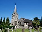 More images |
| Church of St Paulinus | St Paul's Cray | Church | Late 12th century or early 13th century | 25 August 1954 | TQ4739369086 51°24′06″N 0°07′03″E / 51.40166°N 0.117527°E / 51.40166; 0.117527 (Church of St Paulinus) | 1064396 |  More images |
| Church of St Peter and St Paul | Bromley | Church | 1855 | 10 January 1955 | TQ4012169245 51°24′18″N 0°00′47″E / 51.40493°N 0.013119°E / 51.40493; 0.013119 (Church of St Peter and St Paul) | 1084373 |  More images |
| Church of St Peter and St Paul | Cudham | Church | Anglo Saxon origins | 31 May 1954 | TQ4449759952 51°19′13″N 0°04′20″E / 51.320328°N 0.072216°E / 51.320328; 0.072216 (Church of St Peter and St Paul) | 1359355 | 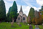 More images |
| Crystal Palace National Sports Centre | Bromley | Sports centre | 1960–64 | 2 December 1997 | TQ3447570894 51°25′16″N 0°04′03″W / 51.421114°N 0.067377°W / 51.421114; -0.067377 (Crystal Palace National Sports Centre) | 1031539 | 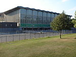 More images |
| Keston Parish Church | Keston | Church | 12th-century origin | 10 January 1955 | TQ4184163002 51°20′54″N 0°02′07″E / 51.348404°N 0.035341°E / 51.348404; 0.035341 (Keston Parish Church) | 1064343 |  More images |
| Kevington Hall | Orpington | Country house | Late 18th century | 31 May 1954 | TQ4793967640 51°23′19″N 0°07′29″E / 51.388525°N 0.124769°E / 51.388525; 0.124769 (Kevington Hall) | 1359374 | 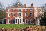 More images |
| Parish Church of St George | Beckenham | Church | 1902–03 | 28 May 1954 | TQ3747769644 51°24′33″N 0°01′29″W / 51.409162°N 0.024714°W / 51.409162; -0.024714 (Parish Church of St George) | 1054025 | 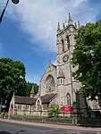 More images |
| Church of the Annunciation | Chislehurst | Church | 1868–70 | 29 June 1973 | TQ4383970931 51°25′09″N 0°04′02″E / 51.41915°N 0.067219°E / 51.41915; 0.067219 (Church of the Annunciation) | 1359325 |  More images |
| Quernmore Secondary School | Bromley | House | About 1777 | 10 January 1955 | TQ4019270453 51°24′57″N 0°00′53″E / 51.415768°N 0.014616°E / 51.415768; 0.014616 (Quernmore Secondary School) | 1055761 |  Upload Photo |
| Orpington Priory | Orpington | House | 15th century | 31 May 1954 | TQ4657766533 51°22′44″N 0°06′17″E / 51.378931°N 0.104752°E / 51.378931; 0.104752 (Orpington Priory) | 1064330 |  More images |
| Subway, Vestibule, Terrace and Stairs to the Crystal Palace | Crystal Palace | Subway | 26 September 1972 | TQ3379170972 51°25′19″N 0°04′38″W / 51.421977°N 0.077179204°W / 51.421977; -0.077179204 (Subway, Vestibule, Terrace and Stairs to the Crystal Palace) | 1385457 |  More images |
Notes
- ^ a b The date given is the date used by Historic England as significant for the initial building or that of an important part in the structure's description.
- ^ a b Sometimes known as OSGB36, the grid reference is based on the British national grid reference system used by the Ordnance Survey.
- ^ a b The "List Entry Number" is a unique number assigned to each listed building and scheduled monument by Historic England.
External links
 Media related to Grade I listed buildings in the London Borough of Bromley at Wikimedia Commons
- Media related to Grade II* listed buildings in the London Borough of Bromley at Wikimedia Commons
- v
- t
- e
- Anerley
- Aperfield
- Beckenham
- Berry's Green
- Bickley
- Biggin Hill
- Bromley
- Bromley Common
- Chelsfield
- Chislehurst
- Coney Hall
- Crystal Palace
- Cudham
- Downe
- Eden Park
- Elmers End (including Upper Elmers End)
- Elmstead
- Farnborough
- Foxbury
- Goddington
- Green Street Green
- Hayes
- Hazelwood
- Hockenden
- Horns Green
- Keston
- Kevington
- Leaves Green
- Locksbottom
- Longlands
- Luxted
- Mottingham
- New Beckenham
- Orpington (including: Broom Hill, Crofton, Derry Downs and Ramsden)
- Park Langley
- Penge
- Petts Wood
- Plaistow
- Poverest
- Pratt's Bottom
- Ruxley
- St Mary Cray
- St Paul's Cray
- Shortlands
- Single Street
- Southborough
- South Street
- Sundridge
- Sydenham
- Upper Norwood
- West Wickham
- Widmore


- Betts Park
- Chislehurst Common
- Crofton Wood
- Croydon Road Recreation Ground
- Crystal Palace Park
- Cuckoo Wood
- Downe Bank
- Elmstead Wood
- Hayes Common
- High Elms Country Park
- Jubilee Country Park
- Kelsey Park
- Keston Common
- Norman Park
- Ruxley Gravel Pits
- Saltbox Hill
- Scadbury Park
- Sundridge Park
- The Warren
- West Kent Golf Course nature reserve
- Beckenham
- Bromley and Chislehurst
- Lewisham West and Penge
- Orpington
tram stops

 Anerley
 Avenue Road
- Beckenham Road
- Beckenham Junction
- Bickley
- Birkbeck
- Bromley North
- Bromley South
- Chelsfield
- Chislehurst
- Clock House
- Crystal Palace
- Eden Park
- Elmers End
- Elmstead Woods
- Hayes
- Kent House
- Knockholt
- Lower Sydenham
- New Beckenham
- Orpington
- Penge East
- Penge West
- Petts Wood
- Ravensbourne
- St Mary Cray
- Shortlands
- Sundridge Park
- West Wickham


- Coat of arms
- Council
- Grade I and II* listed buildings
- Parks and open spaces
- People
- Public art
- Schools
 Category
- Commons

Portals:
 London
 Architecture


