Gopalapuram, Chennai
Neighborhood in Chennai, India
Neighborhood in Chennai, Tamil Nadu, India
13°03′00″N 80°15′30″E / 13.05°N 80.2582°E / 13.05; 80.2582600086
Gopalapuram is a prime residential locality in Chennai, Tamil Nadu, India. It is surrounded by Royapettah in the North and East, Mylapore in the South-East, Teynampet in the South and Thousand Lights in the West. It is located 17 km (11 mi) from the Chennai International Airport and 3 km (1.9 mi) from Chennai Central railway station. It is located in between Dr. Radhakrishnan Salai and Anna Salai. Avvai Shanmugam Road passes through Gopalapuram, dividing it into North Gopalapuram and South Gopalapuram. Gopalapuram comes under Chennai Central Lok Sabha constituency.
Educational institutions
Gopalapuram has many schools which are considered to be the best in Chennai. The educational institutions at Gopalapuram include:
- DAV Girls Senior Secondary School
- DAV Boys Senior Secondary School
- National Public School
- Sri Sarada Secondary School (Affiliated to the CBSE)
- Church Park Convent
- Gopalapuram Boys Higher Secondary School
- Ganapathy Girls Higher Secondary School
Important places
- Sri Venugopalaswamy Temple
- Residence of the family of DMK leader and former chief minister of Tamil Nadu, Muthuvel Karunanidhi
- U.S. Consulate General
- Semmozhi Poonga (Literally translated to "Classical Language Park") is a botanical garden in Chennai set up by the horticulture department of the Government of Tamil Nadu. The garden was opened on 24 November 2010 by the then chief Minister Karunanidhi and is the first botanical garden in the city.
- Khadi Gramodyog Bhavan
Colleges
Hospitals
Libraries
- Easwari Lending Library, oldest in the city of Chennai.
Theaters
- SPI Cinemas, popularly known as "Satyam cinemas".
Business
- Rane Group headquarters
Gallery
-
 Artificial pond at the Semmozhi Park
 -
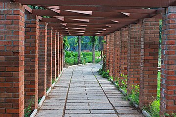 Walkway at Semmozhi park
 -
 Dr. Agarwal Eye Hospital


References
- ^ http://www.vigeyegpms.in/bbmp/?module=public&action=wardinfo&wardid=109
- v
- t
- e
Neighbourhoods of Chennai (city)
- Adyar
- Adambakkam
- Alapakkam
- Alandur
- Alwarpet
- Alwarthirunagar
- Ambattur
- Aminjikarai
- Anna Nagar
- Anna Nagar West
- Annanur
- Andarkuppam
- Arumbakkam
- Ashok Nagar
- Athipattu
- Avadi
- Ayanavaram
- Besant Nagar
- Chepauk
- Chembarambakkam
- Chengalpattu
- Chetput
- Choolai
- Choolaimedu
- Edayanchavadi
- Egmore
- Ennore
- Ernavoor
- Foreshore Estate
- Georgetown
- Greenways Road
- Guduvancheri
- Gummidipoondi
- Guindy
- Guindy TVK Estate
- ICF Colony
- Injambakkam
- Irumbuliyur
- Irungattukottai
- The Island
- Jawahar Nagar
- K. K. Nagar
- Kandanchavadi
- Kannammapet
- Karapakkam
- Karanodai
- Kathivakkam
- Kattankulathur
- Kavaraipettai
- Kelambakkam
- Kilambakkam
- Kilpauk
- Kanathur
- Kodambakkam
- Kodungaiyur
- Kolathur
- Komakkambedu
- Korattur
- Kosappur
- Kottivakkam
- Kotturpuram
- Kovalam
- Kovilambakkam
- Koyambedu
- Kundrathur
- Madipakkam
- Madhavaram
- Madhavaram Milk Colony
- Maduravoyal
- Mamallapuram
- Manali
- Manali New Town
- Manapakkam
- Mandavelli
- Mangadu
- Manjambakkam
- Maraimalai Nagar
- Mathur
- Medavakkam
- Meenambakkam
- Minjur
- Mogappair
- Moolakadai
- Muttukadu
- Mylapore
- Nandanam
- Nandambakkam
- Nandiambakkam
- Nanganallur
- Navalur
- Neelankarai
- Nerkundram
- Nesapakkam
- Nolambur
- Nungambakkam
- Padi
- Palavakkam
- Palavanthangal
- Pallikaranai
- Panagal Park
- Park Town
- Parry's Corner
- Pattabiram
- Pattaravakkam
- Pazhaverkadu
- Perambur
- Periapalayam
- Perumbakkam
- Perungudi
- Pondy Bazaar
- Ponneri
- Poonamallee
- Porur
- Potheri
- Pudhur
- Purasawalkam
- Puzhal
- Puzhuthivakkam
- Red Hills
- Royapettah
- Royapuram
- Sadayankuppam
- Saidapet
- Santhome
- Semmencherry
- Sholavaram
- Sholinganallur
- Shenoy Nagar
- Singaperumalkoil
- Siruseri
- Sithalapakkam
- Sriperumbudur
- Sunguvarchatram
- Surapet
- Sowcarpet
- St. Thomas Mount
- T. Nagar
- Tharamani
- Teynampet
- Thirumangalam
- Thirumazhisai
- Thirumullaivoyal
- Thiruninravur
- Thiruvanmiyur
- Thiruvidandhai
- Thiruporur
- Thuraipakkam
- Tirusulam
- Tiruverkadu
- Tiruvottiyur
- Tolgate
- Tondiarpet
- Triplicane
- Trustpuram
- Urapakkam
- Vadapalani
- Vadaperumbakkam
- Valasaravakkam
- Vallalar Nagar
- Vanagaram
- Vandalur
- Velachery
- Veppampattu
- Vichoor
- Villivakkam
- Vinayagapuram
- Virugambakkam
- Vyasarpadi
- Washermanpet
- West Mambalam


This city of Chennai location article is a stub. You can help Wikipedia by expanding it. |
- v
- t
- e


