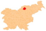
Golavabuka
Place in Styria, Slovenia
46°29′25.78″N 15°10′9.2″E / 46.4904944°N 15.169222°E / 46.4904944; 15.169222 Slovenia
 (2002)
Golavabuka (pronounced [ɡɔlaʋaˈbuːka]) is a settlement in the City Municipality of Slovenj Gradec in northern Slovenia. The area is part of the traditional region of Styria. The entire municipality is now included in the Carinthia Statistical Region.[2]
The local churches is dedicated to Saints Phillip and James and belong to the Parish of Šmartno pri Slovenj Gradcu. It was a Romanesque building that was rebuilt in the 16th century.[3]
References
External links
- Golavabuka on Geopedia
- v
- t
- e
Administrative seat: Slovenj Gradec
| Current | |
|---|---|
| Former |
|

- Holy Spirit Chapel
- Rothenturn Mansion
- St. Elizabeth's Parish Church
 | This article about the Municipality of Slovenj Gradec in Slovenia is a stub. You can help Wikipedia by expanding it. |
- v
- t
- e


