Franklin Street, Adelaide
Street in Adelaide, South Australia


West end
East end
- 34°55′40″S 138°35′16″E / 34.927740°S 138.587740°E / -34.927740; 138.587740 (West end)
- 34°55′38″S 138°35′59″E / 34.927161°S 138.599834°E / -34.927161; 138.599834 (East end)
Adelaide
- Morphett Street
- Victoria Square
Adelaide
Franklin Street is a main street in the Adelaide city centre, South Australia.
Extent
Franklin Street terminates at its western end at West Terrace. The eastern end merges into the northern edge of Victoria Square and continues across King William Street as Flinders Street. [2][3]
History

The street was named on 23 May 1837 in honour of John Franklin, Arctic explorer and Governor of Tasmania.[4]
Rev. James Maughan founded the Methodist New Connection in Flinders Street, which as of 1922 was the Central Mission.[5][6] The Maughan Uniting Church, built in 1965, was demolished in 2016.[7]
2011 redevelopment
In 2011, the street commenced a mid-scale redevelopment of four major buildings:[8]
- 50m 71–83 Franklin Street [Approved in 2014]
- 67m 42–56 Franklin Street [Approved in 2013]
- 72m City Central 8 [U/C – 2012]
- 73m 58–76 Franklin Street [U/C – 2014][9]
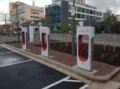
Tesla superchargers
In 2017, the first Tesla Superchargers in South Australia were installed in Franklin Street, , along with generic vehicle chargers. This completed an Australian Tesla charging network that stretches as far as the Brisbane, over 2,000 km (1,200 mi) away.[10]
Notable buildings
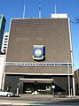
Franklin Street is the location of the Adelaide General Post Office, Eynesbury Senior College, the Adelaide Central bus station, and various companies.
Gallery
-

-
 Eynesbury College
 -
 Maughan Church, 1896
 -
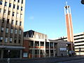 Maughan Church, 2010 (built 1965)
 -
 Maughan Uniting Church, 2014
 -
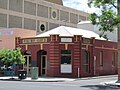 Publishers Limited, 2012 (built 1914)
 -


See also
 Australian Roads portal
References
- ^ Google (1 June 2022). "Franklin Street" (Map). Google Maps. Google. Retrieved 1 June 2022.
- ^ 2003 Adelaide Street Directory, 41st Edition. UBD (A Division of Universal Press Pty Ltd). 2003. ISBN 0-7319-1441-4.
- ^ Map Archived 25 March 2017 at the Wayback Machine of the Adelaide CBD, North Adelaide and the Adelaide Parklands.
- ^ History of Adelaide Through Street Names, historysouthaustralia.net
- ^ "Death of Mr. M. M. Maughan". The Register (Adelaide). Vol. LXXXVI, no. 25, 266. South Australia. 19 December 1921. p. 7. Retrieved 12 December 2022 – via National Library of Australia.
- ^ "In memoriam". Australian Christian Commonwealth. Vol. XXXIV, no. 1736. South Australia. 20 January 1922. p. 14. Retrieved 12 December 2022 – via National Library of Australia.
- ^ Final pieces of gothic Maughan Church set to fall The Advertiser, 13 September 2016. Retrieved 27 May 2017.
- ^ "Franklin Street, Adelaide – A street in transition, Part 2". Urban Rediscovery: Creating Better Communities. 11 April 2011. Retrieved 12 December 2022.
- ^ "Franklin Street & Young Redevelopment Stage 3 Carpark Extension Project in Adelaide, SA". Cordell Connect. Retrieved 12 December 2022.
- ^ Spence, Andrew (28 September 2017). "Tesla charging stations to link Adelaide with world's largest battery". RenewEconomy. Retrieved 12 December 2022.
- v
- t
- e
Streets and squares of Adelaide city centre
|
| ||||||||||


 | This article about Adelaide is a stub. You can help Wikipedia by expanding it. |
- v
- t
- e
 | This Australian road or road transport-related article is a stub. You can help Wikipedia by expanding it. |
- v
- t
- e


