Fort Flagler State Park
State historic park in Washington state, United States
48°05′50″N 122°41′42″W / 48.09722°N 122.69500°W / 48.09722; -122.69500[1]Fort Flagler
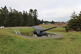
Gun emplacement at Fort Flagler
Fort Flagler State Park is a public recreation area that occupies the site of Fort Flagler, a former United States Army fort at the northern end of Marrowstone Island in Washington.[2] The state park occupies 1,451 acres (587 ha) south of the entrance to Admiralty Inlet, and the Marrowstone Point Light stands adjacent. Port Townsend is visible to the northwest, the cranes at the Navy base on Indian Island to the west, and Whidbey Island to the east across Admiralty Inlet. Flagler Road (SR 116) terminates at the park entrance.
History
Fort Flagler was a Coast Artillery fort that along with Fort Worden and Fort Casey once guarded Admiralty Inlet, the nautical entrance to Puget Sound. Admiralty Inlet was considered so strategic to the defense of Puget Sound that the three forts were placed at the entrance with huge guns creating a "triangle of fire." This military strategy was built on the theory that the three fortresses would thwart any invasion attempt by sea.[3][4] Fort Flagler was established in 1897 and activated in 1899. The post was named for Brigadier General Daniel Webster Flagler, an American Civil War veteran who served as the Army's Chief of Ordnance. The fort was closed in June 1953.[5][6][7] The property was purchased as a state park in 1955.[2]
Amenities and activities

Fort Flagler has hiking and biking trails, campsites, group campsites, boat launches, and historical buildings where visitors can stay - the Hospital Steward's House, the Waterway House, and the North and South Non-Commissioned Officers' Quarters. The park's museum features exhibits about the history of the fort. A schedule of guided tours us available.[2] The park plays host to the annual conferences and meetings of many area cultural and athletic groups.[citation needed]
References
- ^ a b "Fort Flagler State Park". Geographic Names Information System. United States Geological Survey, United States Department of the Interior.
- ^ a b c "Fort Flagler State Park". Washington State Parks and Recreation Commission. Retrieved November 4, 2018.
- ^ McClary, Daryl C. (November 11, 2005). "Triangle of Fire - The Harbor Defenses of Puget Sound (1897-1953)". The Online Encyclopedia of Washington State History. HistoryLink. Retrieved November 4, 2018.
- ^ "Fort Flagler". Coast Defense Study Group. Retrieved November 4, 2018.
- ^ Marge Mueller, Ted Mueller, Washington State Parks: A Complete Recreation Guide, 2004, page 51
- ^ Richard E. Osborne, World War II Sites in the United States: A Tour Guide & Directory, 1996, page 278
- ^ Washington State Adjutant General, The Official History of the Washington National Guard: Washington National Guard in World War I, 1961, page 454
External links
Wikimedia Commons has media related to Fort Flagler State Park.
- Fort Flagler State Park Washington State Parks and Recreation Commission
- Fort Flagler State Park Map Washington State Parks and Recreation Commission
- v
- t
- e
Protected areas of Washington
| Former state parks |
|---|
- Marine protected areas
- Blanchard Forest
- Cascadia Marine Trail
- The Enchantments
- Goose Island
- Les Hilde Trail & Trailheads
- Little Pend Oreille
- Maritime Washington National Heritage Area
- Mount Adams Recreation Area
- Sehome Hill Arboretum
- Walker Valley ORV Riding Area
- Withrow Moraine
- Yellow Island

| |
|---|---|
| Topics | |
| Lists by state |
|
| Lists by insular areas | |
| Lists by associated state | |
| Other areas | |
| Related | |
| |

| Authority control databases |
|
|---|


