Willie Keil's Grave State Park Heritage Site, part of the Washington State Parks system, is located on Washington State Route 6 north of Menlo, Washington, and 5 miles southeast of Raymond. The park is the burial site of Willie Keil, known as the "Pickled Pioneer".
History
Willie Keil was born January 12, 1836, in Bethel, Missouri, to German-born American immigrants Dr. William Keil and Louisa Reiter. The family was part of a religious community, known as Bethelites, who planned to migrate to the West. Willie had trained to drive an ox wagon and would have been the lead driver for the migration expedition. Before departure, Willie became ill with malaria and died on May 19, 1855, four days before the trek was to leave Missouri. Willie, before his death, asked his father to continue the journey regardless of Willie's illness. Dr. Keil honored his son's wishes and transported Willie's body during the pilgrimage, preserving the remains in a whiskey-filled lead-lined coffin as the wagon train traveled to the Washington Territory. Willie would be buried on December 26, 1855, on the hill that overlooks the state park.[1][2][3] Due to the nature of Willie's embalming, he was given the moniker, the "Pickled Pioneer".[4]
As Dr. Keil did not find the area suitable for the building of a community,[4] most members of the wagon train resettled at Aurora, Oregon. Other pioneers are also interred at the park.[5] A family descended from the original expedition donated the 0.34 acres (0.14 ha) for the park in 1959.[4]
Park features
The hill where Willie Keil's body was buried
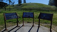
Hikers and bicyclists using the Willapa Hills Trail can access the site by making a slight crossing over the highway. The park has a heritage marker and interpretive panels. The gravesite itself is not accessible to the public.[6]
^Patrich, Chris (May 6, 2019). "Facelift planned for Willie Keil's Grave State Park Heritage Site near Menlo". The Chinook Observer. Retrieved August 22, 2023.
^ abcMcDonald, Julie (October 26, 2022). "Pickled Pioneer's Resting Place Sparks Toledo Man's Memories". The Chronicle. Retrieved August 22, 2023.
^"WILLIE KEIL'S GRAVE STATE PARK HERITAGE SITE". parks.state.wa.us/. Washington State Parks.
Sources
Willie Keils Grave State Park, Lonely Planet, retrieved April 16, 2022
Nordstrand, Dorothea (May 10, 2003), "The Story of Willie Keil", HistoryLink, Seattle: History Ink
Jeff Davis; Al Eufrasio; Mark Moran; Mark Sceurman (2008). "Pickled Willie's grave". Weird Washington: Your Travel Guide to Washington's Local Legends and Best Kept Secrets. Weird US. Sterling. p. 226. ISBN 978-1402745454.
Burlingame, Jeff (2021). Moon Olympic Peninsula: Coastal Getaways, Rainforests & Waterfalls, Hiking & Camping. Moon Publications. Avalon. ISBN 978-1640494411.
External links
Willie Keil's Grave State Park Heritage Site at Washington State Parks