Fairfield Park Precinct
33°52′28″S 150°57′34″E / 33.8744°S 150.9595°E / -33.8744; 150.9595
Fairfield Park Precinct, or Fairfield Park, is an urban park situated in the western suburbs of Sydney, New South Wales, Australia.[1] Situated to the south of Fairfield CBD, the park contains an open grassland, bushland, picnic spots, playgrounds, indoor and outdoor sport facilities, and recreational areas within the vicinity of native plants, such as eucalyptus trees.[2]
Facilities
The park contains several recreation and sporting attractions such as Fairfield Bowling Club, tennis courts, a 7,500 square metre obstacle course with 3 metre high tree top walk,[3] and a recently constructed nature playground, Fairfield Adventure Park, a large playground for older children and teens, which was opened in April 2015. Costing $1.4 million, the playground features an 11 metre high climbing net, a sky bridge and three-slide combination, one of the tallest of its type in the country, and a 33 metre long double flying fox.[4]
The park also features Fairfield Youth and Community Centre, a large hall which opened in October 2015, that contains basketball courts, trampolines, a rock climbing wall, program rooms and extra parking spaces. Adjacent is the Fairfield Leisure Centre, an aquatic centre, which has two swimming pools (indoor and outdoor), a mini-water park, a squash court and a gym.[5]
Geography

Indigenous trees and shrubs are plenteous in the park, which are a remnant of the Cumberland Plain Woodland and Cooks River/Castlereagh Ironbark ecological community, with vegetation species that include Melaleuca decora, Eucalyptus amplifolia, Eucalyptus moluccana, Eucalyptus baueriana, Eucalyptus fibrosa, Eucalyptus teriticornis, angophora floribunda, Casuarina glauca, Callistemon viminalis, Ficus microcarpa, Camphor laurel, Bursaria spinosa, Indigofera australis and Eucalyptus bosistoana, most of which have large canopies that provide shade for visitors.
Prospect Creek winds on the eastern end of the park and there is a pedestrian bridge above it, providing views over the creek. The vegetation that surrounds the reserve's creekline is within the riparian zone. The fauna commonly includes Australian birds, such as the Australian raven, Australian magpie and the galah.[6]
All in all being 18 hectares (44.48 acres) in size, the park proper (which excludes the area south of Prospect Creek, around Orphan School Creek) is around 12 hectares (29.65 acres) in size. Hypothetically, if Makepeace Oval, a sports field across the road to the northeast, was included within the park's precinct, then the overall size of the parkland will be approximately 21 hectares (51.89 acres).[7]
Transport
The park is situated on Vine Street and is only a 10-minute walk from Fairfield railway station. It contains a number of walkways and cycleways, namely near Prospect Creek, which link it to Carramar to the south and Fairfield East to the east. The Horsley Drive is a major arterial road on the east side of the parkland. There is also an entry to the park from Haughton Street in Carramar to the south, via a walk/cycleway, adjoining Heiden Park to the west.[8]
Heritage
Honour Avenue, situated on the entrance of Fairfield Park, is a memorial gateway that commemorates Australia's involvement in various 20th century wars. It was built in honour of the Fairfield residents who served in the World Wars and it includes the names of World War II personnel. Its connecting metal arch displays the words: '1939 Honour Avenue 1945'. The avenue therein contains large brush Boxes and hill's weeping figs on both sides and public seating.[9]
Crime
In February 2013, a body of a young man, a homicide victim, was located in the park's oval at around 4am by police and paramedics.[10][11] In April 2014, two 16 year old girls who skipped school were raped by three men in broad daylight within the park grounds.[12]
Gallery
-
 Honour Avenue acts as the main entrance to the park.
 -
 Prospect Creek
 -
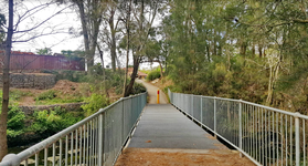 The pedestrian bridge over the creek
 -
 A seating area within the woodland
 -
 Entrance from the southern end of the park, in Haughton Street Carramar
 -
 The park's open grassland


See also
- Brenan Park
- Rosford Street Reserve
- Bland Oak, a historical tree just to the south of the park's borders
References
- ^ King Michael & Associates (1997) Recreation Needs Assessment Study prepared for Fairfield City Council
- ^ Fairfield City Council (December 1999) Vision for Fairfield Fairfield City Council
- ^ Obstacle course at Fairfield Park
- ^ "Fairfield Adventure Park". Archived from the original on 20 December 2016. Retrieved 22 October 2018.
- ^ Fairfield City Council (1999) Management Plan for Fairfield City 1999-2003 Fairfield City Council
- ^ Fairley A and Moore P (1995) Native Plants of Sydney District – an identification guide Kangaroo Press, Sydney
- ^ Clouston (1999) Fairfield Open Space Strategy prepared for Fairfield City Council
- ^ Fairfield City Council (1994) Local Environment Plan Fairfield City Council
- ^ "Fairfield City Centre Development Control Plan" (PDF). Archived from the original (PDF) on 17 April 2018. Retrieved 22 October 2018.
- ^ Police investigate drug links to Fairfield and Cabramatta murders by The Daily Telegraph, November 3, 2016
- ^ Two bodies discovered in separate incidents in Fairfield and Mt Druitt by News.com.au
- ^ Girls who skipped school raped in Fairfield Park: police by Rachel Olding and Megan Levy, 9 April 2014, Sydney Morning Herald
- v
- t
- e
Sydney landmarks
- Admiralty House
- Archibald Fountain
- Australia Square
- Bankstown Reservoir
- Boothtown Aqueduct
- Cadmans Cottage
- Campbell's Stores
- The Cenotaph
- Central station
- Chifley Tower
- Citigroup Centre
- International Convention Centre
- Deutsche Bank Place
- Dr Chau Chak Wing Building
- El Alamein Fountain
- Finger Wharf
- General Post Office (No. 1 Martin Place)
- Government House
- Governor Phillip Tower
- Hong Kong House
- Hyde Park Barracks
- King Street Wharf
- Kirribilli House
- Long Bay
- Macquarie Lighthouse
- Mint
- Observatory
- Old Government House
- Old Mining Museum Building
- Opera House
- Overseas Passenger Terminal
- Parliament House
- Parramatta Gaol
- Regimental Square
- The Ribbon
- Queen Victoria Building
- St Andrew's Cathedral
- St Mary's Cathedral
- Sydney Airport
- Sydney Tower
- The Toaster
- Town Hall
- War Memorial
- Warragamba Dam
- White Bay Cruise Terminal
- World Square
- World Tower
- Auburn Botanic Gardens
- Balaka Falls
- Balls Head Reserve
- Bents Basin
- Berowra Valley National Park
- Bicentennial Park
- Bland Oak
- Blue Mountains National Park
- Brenan Park
- Centennial Parklands
- Central Gardens Nature Reserve
- Chinese Garden of Friendship
- Chipping Norton Lake
- Cronulla sand dunes
- Fairfield Park Precinct
- Farm Cove
- Featherdale Wildlife Park
- Field of Mars Reserve
- Fred Hollows Reserve
- Garigal National Park
- Garawarra Conservation Area
- Georges River National Park
- Heathcote National Park
- Hyde Park
- Kamay Botany Bay National Park
- Ku-ring-gai Chase
- Lake Parramatta
- Lane Cove National Park
- Macquarie Place
- Mrs Macquarie's Chair
- Paddington Reservoir
- Parramatta Park
- Prospect dolerite intrusion
- Prospect Hill
- Prospect Nature Reserve
- Rosford Street Reserve
- Royal Botanic Garden
- Royal National Park
- Sydney Harbour National Park
- Sydney Park
- The Domain
- Western Sydney Parklands
- Western Sydney Regional Park
- Wetherill Park Nature Reserve
- Art Gallery of New South Wales
- Australian Museum
- Australian National Maritime Museum
- Chau Chak Wing Museum
- Harry's Cafe de Wheels
- Manly Art Gallery and Museum
- Museum of Contemporary Art
- Museum of Sydney
- Justice and Police Museum
- Powerhouse Museum
- Sea Life Sydney Aquarium
- State Library
- Sydney Conservatorium of Music
- Sydney Zoo
- Taronga Zoo
- Australian Golf Club
- Canterbury Park Racecourse
- Dunc Gray Velodrome
- Lakes Golf Club
- Macquarie Ice Rink
- Randwick Racecourse
- Rosehill Gardens Racecourse
- Royal Sydney Golf Club
- Stadium Australia
- State Sports Centre
- Sydney Cricket Ground
- Sydney Football Stadium
- Sydney International Regatta Centre
- Sydney Motorsport Park
- Sydney Olympic Park
- Sydney Olympic Park Athletic Centre
- Sydney Olympic Park Aquatic Centre
- Sydney Olympic Park Hockey Centre
- Sydney Olympic Park Tennis Centre
- Sydney Showground Stadium
- Warwick Farm Racecourse
- Wentworth Park
- Western Sydney International Dragway
- Western Sydney Stadium
- Bare
- Clark
- Cockatoo
- Fort Denison
- Garden
- Goat
- Rodd
- Shark
- Snapper
- Spectacle


