Bradleys Head
Headland in Sydney, New South Wales, Australia
33°51′9″S 151°14′45″E / 33.85250°S 151.24583°E / -33.85250; 151.24583
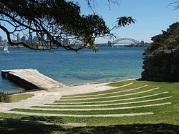
Bradleys Head is a headland protruding from the north shore of Sydney Harbour, within the metropolitan area of Sydney, New South Wales, Australia. It is named after the First Fleet naval officer William Bradley. The original Aboriginal inhabitants, who belonged to the Borogegal clan of the Eora nation, knew Bradleys Head as Borogegy, Booraghee, Booragy or Burrogy. On the headland is an active lighthouse, Bradleys Head Light, constructed in 1905.[1]
Bradleys Head is now a unit of the Sydney Harbour National Park and managed by the National Parks and Wildlife Service.[2]
History

The foremast of the cruiser HMAS Sydney, renowned for taking part in the Royal Australian Navy's first ship-against-ship engagement in World War I, is mounted on the headland as a memorial to that battle. In June 2000 the mast was rededicated as a monument to all Australian ships and sailors lost in conflict.

Sitting on the rock platform off the headland is a Doric stone column. It is one of six that were taken from the demolished Sydney Post Office and placed in positions in Sydney. In conjunction with the tower off Fort Denison, it was used for speed trials of vessels in Sydney Harbour. Owing to increased congestion on the Harbour, it is no longer used by the Maritime Services Board for this purpose.[3] (Another of the columns can be seen in the Mount Street Plaza, North Sydney.)
The heritage-listed Bradleys Head Light, completed in 1905, is located on the point of Bradley's Head Peninsula and used as a navigation marker and warning light to ships entering and leaving the harbour. The lighthouse is mounted on a rock and connected to shore by a footbridge.[4]
Nearby Athol Bight was used from the end of World War 2 to the mid-1980s to store naval ships. The headland was used for shooting scenes for the film Mission: Impossible 2 (2000). A polystyrene house seen in the film was built there, then removed after shooting was completed.
See also
- Bradleys Head Fortification Complex
- Clark Island
- Dobroyd Head
- Goat Island
- Middle Head
- Nielsen Park
- Rodd Island
- Shark Island
- Sydney Heads
References
- ^ Rowlett, Russ. "Lighthouses of Australia: Northern New South Wales". The Lighthouse Directory. University of North Carolina at Chapel Hill. Retrieved 29 August 2010.
- ^ Carment, David (2010). "Bradleys Head". Dictionary of Sydney. Retrieved 28 March 2016.
- ^ "Place ID 2875". Australian Heritage Database. Australian Government.
- ^ "Bradleys Head Light Tower". New South Wales State Heritage Register. Department of Planning & Environment. H01430. Retrieved 2 June 2018.
 Text is licensed by State of New South Wales (Department of Planning and Environment) under CC-BY 4.0 licence.
External links
- Carment, David; Mosman Historical Society (2011). "Bradleys Head". Dictionary of Sydney. Dictionary of Sydney Trust. Retrieved 6 October 2015. [CC-By-SA]
- v
- t
- e
Parks and gardens in Sydney, Australia
- Balfour Street Park
- Barangaroo Reserve
- Belmore Park
- Centennial Parklands
- Centennial Park
- Moore Park
- Chinese Garden of Friendship
- The Domain
- Hyde Park
- Jessie Street Gardens
- Macquarie Place Park
- Observatory Park
- Paddington Reservoir
- Prince Alfred Park
- Redfern Park
- Royal Botanic Garden
- Sydney Cove West Archaeological Precinct
- Sydney Park
- Victoria Park
- Wentworth Park
- Wild Life Sydney
- Wynyard Park
- Anderson Park, Neutral Bay
- Angophora Reserve
- Astrolabe Park
- Auburn Botanic Gardens
- Australian Botanic Garden Mount Annan
- Ballast Point
- Balls Head Reserve
- Bede Spillane Gardens
- Ben Buckler Park
- Bents Basin State Conservation Area
- Berowra Valley Regional Park
- Bicentennial Park
- Birchgrove Park
- Bradleys Head
- Brenan Park
- Brickpit Ring Walk
- Burwood Park
- Carss Bush Park
- Centenary Park
- Centenary Square
- Centennial Parklands
- Centennial Park
- Moore Park
- Queen's Park
- Central Gardens Nature Reserve
- Chipping Norton Lake
- Coral Sea Park
- Fagan Park
- Fairfield Park Precinct
- Ferndale Park
- Fred Hollows Reserve
- Garawarra State Conservation Area
- Garigal National Park
- Garrison Point
- George Kendall Riverside Park
- Georges River National Park
- Grey Box Reserve
- Heathcote National Park
- Iloura Reserve
- Ivanhoe Park
- Joseph Banks Native Plants Reserve
- Kamay Botany Bay National Park
- Kellys Bush Park
- Koala Park Sanctuary
- Ku-ring-gai Chase National Park
- Lake Parramatta Reserve
- Lane Cove Bushland Park
- Lane Cove National Park
- Louise Sauvage Pathway
- Lower Prospect Canal Reserve
- Magdala Park
- McLeod Reserve
- Moore Reserve
- Moore Reserve, Oatley
- Mortdale Memorial Park
- Muston Park
- Nielsen Park
- Nurragingy Reserve
- Oatley Park
- Oatley Pleasure Grounds
- Oatley Point Reserve
- Oxford Falls Peace Park
- Parramatta Park
- Penrith Lakes Regional Park
- Petersham Park
- Prince Alfred Square
- Prospect Hill
- Prospect Nature Reserve
- Queen Elizabeth Park
- Rockdale Bicentennial Park
- Rofe Park
- Rosford Street Reserve
- Rowland Park
- St Leonards Park
- St Thomas Rest Park
- Sydney Harbour National Park
- Sydney Zoo
- Tania Park
- Taronga Zoo
- Terry Lamb Complex
- Wadim (Bill) Jegorow Reserve
- Wallumatta Nature Reserve
- Walter Burley Griffin Incinerator, Willoughby
- Waverley Cemetery
- Western Sydney Parklands
- Wetherill Park Nature Reserve
- Yellomundee Regional Park
- Yurulbin Park
Parks and gardens in New South Wales
 | This article related to the geography of Sydney is a stub. You can help Wikipedia by expanding it. |
- v
- t
- e


