Newfoundland and Labrador Route 406

Newfoundland and Labrador Route 406
Brug van Route 406 over het Grand Codroy-estuarium (rechts op de foto)
Newfoundland and Labrador Route 406
Land Canada
Provincie Newfoundland en Labrador
Lengte 21 km
Portaal  Portaalicoon   Verkeer & Vervoer
Canada
Traject
Kruising Doyles 1
Brug over het water Grand Codroy-estuarium
Kruising Millville 407
Kruising Lighthouse Road

Newfoundland and Labrador Route 406, afgekort Route 406 of NL-406, is een 21 km lange provinciale weg van de Canadese provincie Newfoundland en Labrador.[1] De weg bevindt zich in het uiterste zuidwesten van het eiland Newfoundland.

Traject

Route 406 begint als afsplitsing van provinciale route 1 (de Trans-Canada Highway) in Doyles, een dorp in de Codroyvallei. De weg gaat in noordwestelijke richting naar Upper Ferry en steekt daar via een brug het smalste gedeelte van het Grand Codroy-estuarium over.

De route gaat dan westwaarts langsheen de noordoever van dat estuarium en komt via het gehucht Great Codroy uit in het dorp Millville. Daar is een splitsing, met provinciale route 406 die verdergaat in noordwestelijke richting en provinciale route 407 die naar het zuiden toe gaat.

Na de plaatsen Woodville en Codroy te passeren, gaat de weg in noordelijke richting doorheen het gehucht Shoal Point. Na zo'n 21 km eindigt de weg bij Lighthouse Road, het straatje dat leidt naar de vuurtoren van Cape Anguille, het westelijkste punt van Newfoundland.
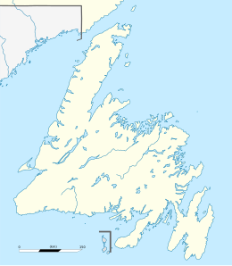
Newfoundland and Labrador Route 406 (Newfoundland)
Cape Anguille
Cape Anguille
Doyles
Doyles
Begin- en eindpunt van Route 406
Bronnen, noten en/of referenties
  1. (en) (fr) MapArt, Canada back road atlas / atlas des rangs et chemins, Oshawa, 2008, p. 562. ISBN 978-1-55368-614-9.
Vlag van Newfoundland en Labrador
· · Sjabloon bewerken
Vlag van Canada
Provinciale routes in Newfoundland en Labrador
Nationale wegen:1 (TCH) · 2 · 40 · 100 · 340 · 350 · 430 · 450A · 500 (TLH) · 510 (TLH)
Schiereiland Avalon:1 (TCH) · 2 · 3 · 3A · 10 · 11 · 13 · 20 · 21 · 30 · 40 · 41 · 50 · 60 · 62 · 63 · 70 · 71 · 72 · 73 · 74 · 75 · 80 · 81 · 90 · 91 · 92 · 93 · 94 · 100 · 101 · 102 · 201 · 202 · 203
Schiereiland Burin:210 · 211 · 212 · 213 · 214 · 220 · 220A · 221 · 222
Schiereiland Bonavista:204 · 205 · 230 · 230A · 231 · 232 · 233 · 234 · 235 · 236 · 237 · 238 · 239
Regio Twillingate—Fogo Island:301 · 310 · 320 · 330 · 331 · 332 · 333 · 334 · 335 · 340 · 341 · 342 · 343 · 344 · 345 · 346
Regio Exploitsvallei—Bay d'Espoir:1 (TCH) · 350 · 351 · 352 · 353 · 360 · 361 · 362 · 363 · 364 · 365 · 370 · 371
Schiereiland Baie Verte:380 · 381 · 382 · 390 · 391 · 392 · 410 · 411 · 412 · 413 · 414 · 415 · 416 · 417 · 418 · 419
Great Northern Peninsula:401 · 420 · 421 · 422 · 430 · 432 · 433 · 434 · 435 · 436 · 437 · 438
Westelijk Newfoundland:1 (TCH) · 402 · 403 · 404 · 405 · 406 · 407 · 408 · 431 · 440 · 450 · 450A · 460 · 461 · 462 · 463 · 470 · 480 · 490
Labrador:500 (TLH) · 503 · 510 (TLH) · 513 · 514 · 516 · 520