Bussière-Galant
Gemeente in Frankrijk  | |||
|---|---|---|---|
 | |||
  | |||
| Situering | |||
| Regio | Nouvelle-Aquitaine | ||
| Departement | Haute-Vienne (87) | ||
| Arrondissement | Limoges | ||
| Kanton | Saint-Yrieix-la-Perche | ||
| Coördinaten | 45° 37′ NB, 1° 2′ OL | ||
| Algemeen | |||
| Oppervlakte | 53,86 km² | ||
| Inwoners (1 januari 2021) | 1.267[1] (24 inw./km²) | ||
| Hoogte | 338 - 551 m | ||
| Overig | |||
| Postcode | 87230 | ||
| INSEE-code | 87027 | ||
| Website | http://www.montsdechalus.fr/ | ||
| |||

Bussière-Galant is een gemeente in het Franse departement Haute-Vienne (regio Nouvelle-Aquitaine) en telt 1386 inwoners (1999). De plaats maakt deel uit van het arrondissement Limoges.

Geografie
De oppervlakte van Bussière-Galant bedraagt 53,2 km², de bevolkingsdichtheid is 26,1 inwoners per km². De onderstaande kaart toont de ligging van Bussière-Galant met de belangrijkste infrastructuur en aangrenzende gemeenten.
 |
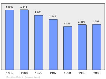
Demografie
Onderstaande figuur toont het verloop van het inwonertal (bron: INSEE-tellingen).
Externe links
- (fr) Statistische informatie op de website van INSEE
Mediabestanden
Zie de categorie Bussière-Galant van Wikimedia Commons voor mediabestanden over dit onderwerp.
- ↑ Populations légales 2021.


