サント=カトリーヌ (パ=ド=カレー県)
| Sainte-Catherine | |
|---|---|
  | |
| 行政 | |
| 国 |  フランス フランス |
| 地域圏 (Région) | オー=ド=フランス地域圏 |
| 県 (département) | パ=ド=カレー県 |
| 郡 (arrondissement) | アラス郡 |
| 小郡 (canton) | アラス1小郡 |
| INSEEコード | 62744 |
| 郵便番号 | 62223 |
| 市長(任期) | アラン・ヴァン・ゲルデール (2014年 - 2020年) |
| 自治体間連合 (fr) | fr:Communauté urbaine d'Arras |
| 人口動態 | |
| 人口 | 3401人 (2012年) |
| 人口密度 | 773人/km2 |
| 住民の呼称 | Sainte-Catherinois |
| 地理 | |
| 座標 | 北緯50度18分28秒 東経2度45分50秒 / 北緯50.3077777778度 東経2.76388888889度 / 50.3077777778; 2.76388888889座標: 北緯50度18分28秒 東経2度45分50秒 / 北緯50.3077777778度 東経2.76388888889度 / 50.3077777778; 2.76388888889 |
| 標高 | 平均:m 最低:53 m 最高:105 m |
| 面積 | 4.4km2 |
  Sainte-Catherine | |
| 公式サイト | ville-sainte-catherine-62.fr |
| テンプレートを表示 | |
サント=カトリーヌ (Sainte-Catherine[Note 1])は、フランス、オー=ド=フランス地域圏、パ=ド=カレー県のコミューン。非公式であるが、サント=カトリーヌ=レ=ザラス(Sainte-Catherine-lès-Arras)と呼ばれることもある。
人口統計
| 1962年 | 1968年 | 1975年 | 1982年 | 1990年 | 1999年 | 2007年 | 2012年 |
|---|---|---|---|---|---|---|---|
| 1629 | 2105 | 2438 | 3203 | 3132 | 3017 | 3355 | 3401 |
source=1999年までLdh/EHESS/Cassini[1]、2004年以降INSEE[2][3]
史跡
-
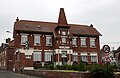 役場
役場 -
 ペシュリー公園
 -
 教会
教会 -
 灰色の十字架


ゆかりの人物
脚注
参照
- ^ Le nom officiel dans le fr:code officiel géographique est « Sainte-Catherine », [lire en ligne]
典拠管理データベース | |
|---|---|
| 全般 |
|
| 国立図書館 |
|
| その他 |
|


