District métropolitain de Wigan

Cet article est une ébauche concernant l’Angleterre.
Vous pouvez partager vos connaissances en l’améliorant (comment ?) selon les recommandations des projets correspondants.

Cet article lié à la géographie doit être recyclé ().
Une réorganisation et une clarification du contenu paraissent nécessaires. Améliorez-le, discutez des points à améliorer ou précisez les sections à recycler en utilisant {{section à recycler}}.
Cette section ou cet article est une traduction incomplète ().
Vous pouvez modifier la page pour effectuer la traduction.
| Wigan | |
 | |
| Administration | |
|---|---|
| Pays |  Royaume-Uni Royaume-Uni |
| Région | Angleterre du Nord-Ouest |
| Comté | Grand Manchester |
| Centre administratif | Wigan |
| Démographie | |
| Population | 328 662 hab. (2019) |
| Densité | 1 746 hab./km2 |
| Géographie | |
| Coordonnées | 53° 32′ 00″ nord, 2° 37′ 00″ ouest |
| Superficie | 18 820 ha = 188,2 km2 |
| Liens | |
| Site web | http://www.wigan.gov.uk |
| modifier | |
Le district métropolitain de Wigan est un district métropolitain du Grand Manchester, dans l'Angleterre du Nord-Ouest. Il est dénommé d'après sa principale ville, Wigan et inclut également les villes de Leigh, Ashton-in-Makerfield, Ince-in-Makerfield, et Hindley. Le district a été formé en 1974 et est la réunion de plusieurs anciennes administrations locales.
Situation géographique
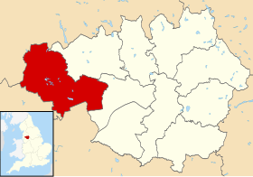
Le district de Wigan est le district occidental du comté métropolitain du Grand Manchester (Greater Manchester). Au nord-est se trouve le district métropolitain de Bolton, tandis que la ville de Salford se situe quant à elle à l’est. En dehors du Grand Manchester, le district de Wigan est bordé au sud par Warrington, autorité unitaire du Cheshire, et au sud-ouest par le district métropolitain de Saint Helens, dépendant du comté de Merveyside. A l’ouest, Wigan est bordé par le district de West Lancashire, tandis qu’au nord se trouve le district de Chorley, dans le Lancashire aussi.
Histoire

Texte anglais à traduire :
The metropolitan borough was created on 1 April, 1974 by the Local Government Act 1972. It was formed from the former county borough of Wigan along with following existing local government units from the administrative county of Lancashire [1],[2]:
- the Municipal Borough of Leigh
- the urban districts of Abram, Aspull, Atherton, Hindley, Ince-in-Makerfield, Orrell, Standish-with-Langtree and Tyldesley
- most of the Ashton-in-Makerfield Urban District (except for the area which now forms the Seneley Green parish in the Metropolitan Borough of St Helens)
- most of the Golborne Urban District (except for the area which now forms the parish of Culcheath and Glazebury in Warrington)
- part of the Billinge and Winstanley Urban District now known as Higher End
- the parishes of Haigh, Shevington and Worthington, from the Wigan Rural District.
Wigan Metropolitan Borough's new coat of arms is based on various elements from the arms of the predecessor districts.
Prior to its creation, the name Wigan-Leigh was used in the Redcliffe-Maud Report. It was then suggested that the new metropolitan borough be named Makerfield (with reference to Makerfield). However both names were rejected for Wigan, by a vote of 12 to 2[3].
From 1974, local government was under a two-tier system, with Wigan Metropolitan Borough Council covering most functions, and the Greater Manchester County Council. The county council was abolished in 1986 by the Local Government Act 1985.
The population of the borough has stayed roughly static since the 1970s at around 300,000[4].
Traduire ce texte • Outils • (+)
Politique
Parlement
Texte anglais à traduire :
Four parliamentary constituencies cover the borough: Wigan, Makerfield, Leigh, and Worsley. Worsley also covers parts of Salford. New constituencies boundaries recommended by the Boundary Commission will see the link to Salford broken, and part of the borough (the Atherton ward) included in the Bolton West constituency[5]. All four seats are considered safe seats for the Labour Party, and they or predecessors have returned Labour members consistently since the Second World War. Makerfield is the only constituency to have returned Labour MPs continuously since 1906[6].
Traduire ce texte • Outils • (+)
Gouvernement local
Texte anglais à traduire :
The first elections to the borough council were held on 10 May 1973[7]. Each ward has three councillors, and elections are by third, with one councillor from each ward up for re-election in each election year[1]. The 2004 election was for all seats, as ward boundaries had changed[8]. The next elections are planned for 2007[9].
The borough council has a leader and cabinet system. The current leader is Peter Smith, who also sits in the House of Lords as a Labour Party life peer, under the title Lord Smith of Leigh. He first became leader in 1991[10]. The council rejected the idea of a directly-elected mayor following a consultation in 2001[11].
The Metropolitan Borough of Wigan is traditionally a Labour stronghold - the council has been Labour Party-controlled since its creation[12]. The local elections in 1998 resulted in a council with only 2 non-Labour members.
Labour have a majority with 43 seats as of the 2006 election. The second largest party on the council is the local Community Action Party, also active in St Helens and Warrington, which had 15 seats. Community Action first contested Wigan elections in 2002, and won 18 seats in the 2004 election following the re-warding - their councilors are for wards in the middle of the borough, between Wigan and Leigh. The Conservative Party has nine seats, and the Liberal Democrats eight[12],[13].
The council uses Wigan Town Hall as its main headquarters[14]. Leigh Town Hall is used as a secondary base[15].
Traduire ce texte • Outils • (+)
Divisions
Texte anglais à traduire :
The borough is divided into 25 electoral wards, each of which elect three councillors. The present wards were adopted in 2003, following a review by the Boundary Commission : the previous review took place in 1979. The borough was formerly divided in 24 wards[16]. The wards are as follows[17]:
Traduire ce texte • Outils • (+)
|
|
Texte anglais à traduire :
The previous wards were
Traduire ce texte • Outils • (+)
|
|
Villes dépendantes
Texte anglais à traduire :
Component areas of the borough include Wigan itself, Abram, Ashton-in-Makerfield, Aspull, Astley, Atherton, Bryn, Golborne, Haigh, Higher End, Hindley, Ince-in-Makerfield, Leigh, Lowton, Orrell, Platt Bridge, Standish, Shevington and Tyldesley.
The ONS identify a Wigan Urban Area as being the west of the district, including Skelmersdale and Upholland in West Lancashire, with a population of 166,840. It considers towns in the east of the borough to be part of the Greater Manchester Urban Area. Ashton-in-Makerfield, Aspull, Golborne and Shevington are identified as standalone urban areas[18].
Traduire ce texte • Outils • (+)
Parishes
Texte anglais à traduire :
The borough has three civil parishes: Haigh, Shevington and Worthington. The rest of the borough is an unparished area. Turning to ecclesiastical parishes, the Wigan Deanery Parishes are under the Anglican Diocese of Liverpool and the Roman Catholic Archdiocese of Liverpool, although Anglican parishes in the east section of the Metropolitan Borough are under the Diocese of Manchester and the northern section under the Diocese of Blackburn.
Traduire ce texte • Outils • (+)
Townships
Texte anglais à traduire :
Wigan Council has divided the borough into ten areas by the name of townships, with a Township Manager and a Township Forum each[19]. The townships are as follows:
Traduire ce texte • Outils • (+)
| Township | Wards |
|---|---|
| Ashton-in-Makerfield / Bryn | Ashton; Bryn |
| Atherton | Atherton |
| Hindley / Abram | Abram; Hindley; Hindley Green |
| Leigh | Atherleigh; Leigh North; Leigh South; Leigh West |
| Lowton / Golborne | Golborne and Lowton West; Lowton East |
| Orrell / Higher End / Winstanley | Orrell; Winstanley; Billinge Higher End |
| Standish / Aspull / Shevington | Aspull-New Springs-Whelley; Shevington with Lower Ground; Standish with Langtree |
| Tyldesley / Astley | Astley-Mosley Common; Tyldesley |
| Wigan North | Ince; Wigan Central; Wigan West |
| Wigan South | Douglas; Pemberton; Worsley Mesnes |
Démographie
Texte anglais à traduire :
With a population of around 300,000, Wigan is the second most populous borough of Greater Manchester, after Manchester itself. It also has one of the lowest non-white populations, with the 2001 census reporting 98.7% of the population as white. Unemployment is around average for England and Wales. 9.5% of the population is "permanently sick or disabled" compared to an average of 5.5%[20].
Traduire ce texte • Outils • (+)
Population
Le tableau ci-dessous présente l’évolution de la population du district de Wigan depuis 1801. Bien que le district ait une existence propre seulement depuis 1974, les statistiques démographiques pour les décennies antérieures ont pu être établies en combinant les données de recensement émanant des villes, villages et paroisses constitutives du district.
| 1801 | 1811 | 1821 | 1831 | 1841 | 1851 | 1861 | 1871 | 1881 |
|---|---|---|---|---|---|---|---|---|
| 41 413 | 50 464 | 60 760 | 69 400 | 78 349 | 93 271 | 120 001 | 146 732 | 173 462 |
| 1891 | 1901 | 1911 | 1921 | 1931 | 1941 | 1951 | 1961 | 1971 |
|---|---|---|---|---|---|---|---|---|
| 212 665 | 239 399 | 269 503 | 267 754 | 266 040 | 266 436 | 266 839 | 284 309 | 302 929 |
| 1981 | 1991 | 2001 | - | - | - | - | - | - |
|---|---|---|---|---|---|---|---|---|
| 307 721 | 310 866 | 301 415 | - | - | - | - | - | - |
(Source : Vision of Britain[21])
Identité
Texte anglais à traduire :
According to an opinion poll, 26% of 299 residents surveyed felt they belonged "very strongly" or "fairly strongly" (4% very strongly) to Greater Manchester, 64% (28% very strongly) to the borough of Wigan, and 63% (31% very strongly) to Lancashire[22].
Traduire ce texte • Outils • (+)
Transports
Texte anglais à traduire :
Several railway lines cross the borough. Wigan Wallgate railway station is served by trains to Southport, Kirkby, Manchester Victoria and Rochdale. Wigan North Western railway station is located on the West Coast Main Line and trains run from there to Liverpool Lime Street and Blackpool North.
Other stations are Atherton, Bryn (Ashton in Makerfield), Gathurst (Shevington), Hindley, Ince, Orrell, and Pemberton. There is also a long running campaign for Golborne railway station to be re-opened.
Leigh is the largest town in the UK whitout a railway station. One station, on the Bolton and Leigh Railway, closed in 1954. The second, on a loop of the Manchester to Wigan Line was closed in 1969[23].
The Leeds and Liverpool Canal passes through the borough, as does the M6 motorway, which runs through the west of the borough, and serves Ashton-in-Makerfield (junctions 23 and 24 (north only) and 25 (south only)), Wigan 25 (south only), Wigan and Orrell (26) and Standish (27). The M58 motorway, to northern Liverpool, terminates at junction 26 of the M6 (Orrell). The A580 (East Lancashire Road), Liverpool to Manchester link, passes through the south of the borough.
Traduire ce texte • Outils • (+)
Jumelage
Depuis 1988, la ville de Wigan est jumelée à la ville d'Angers, en France[24].
Notes et références
(en) Cet article est partiellement ou en totalité issu de l’article de Wikipédia en anglais intitulé « Metropolitan Borough of Wigan » (voir la liste des auteurs).
- ↑ a et b Local Government Act 1972. 1972 c. 60, HMSO
- ↑ Local Government (Successor Parishes) Order 1973. 1973/1110, HMSO
- ↑ Clark 1973, p. 101.
- ↑ (en) « Wigan District population », Vision of Britain, University of Portsmouth (consulté le )
- ↑ (en) « Greater Manchester: New Constituency Boundaries », Martin Baxter (consulté le )
- ↑ (en) « Safe Seats analysis », Electoral Reform Society, (consulté le )
- ↑ (en) « Three major parties find cause for satisfaction in local election results despite low poll », The Times,
- ↑ (en) « Wigan council », BBC News, (consulté le )
- ↑ (en) The Borough of Wigan (Electoral Changes) Order 2004, Her Majesty's Stationery Office (lire en ligne)
- ↑ « Constitution: Part 9 »(Archive.org • Wikiwix • Archive.is • Google • Que faire ?) (consulté le )
- ↑ « Borough rejects elected mayor »(Archive.org • Wikiwix • Archive.is • Google • Que faire ?) (consulté le )
- ↑ a et b (en) « Local elections: Wigan », BBC News, (consulté le )
- ↑ (en) « Labour licks wounds after polls », BBC News, (consulté le )
- ↑ « 21st century Town Hall »(Archive.org • Wikiwix • Archive.is • Google • Que faire ?) (consulté le )
- ↑ « Makeover for Leigh Town Hall »(Archive.org • Wikiwix • Archive.is • Google • Que faire ?) (consulté le )
- ↑ (en) Final recommendations on the future electoral arrangements for Wigan, Boundary Committee, , PDF (lire en ligne)
- ↑ (en) « New Wigan Wards Map », Wigan Metropolitan Borough Council
- ↑ « Table KS01 Usual Resident population »(Archive.org • Wikiwix • Archive.is • Google • Que faire ?) (consulté le )
- ↑ (en) « Townships », Wigan Metropolitan Borough Council (consulté le )
- ↑ (en) « Census 2001 - Profiles - Wigan », Office for National Statistics (consulté le )
- ↑ (en) « Wigan District: total population », Vision of Britain (consulté le )
- ↑ [PDF] (en) « MORI local government and identity opinion poll December 2003 - February 2004 », The Boundary Committee for England (consulté le )
- ↑ (en) « Pennington Station », Disused Stations, Subterranea Britanica (consulté le )
- ↑ (en) « Town twinning with Angers », sur wigan.gov.uk (consulté le )
Bibliographie
- David M. Clark, Greater Manchester Votes : A Guide to the New Metropolitan Authorities, Redrose,
Liens externes
- (en) « The Leeds and Liverpool Canal », Pennine Waterways (consulté le )
- (en) Towpath Treks, « The Leeds & Liverpool Canal in Wigan », (consulté le )
 Portail de Manchester et de son comté


