Comté de Jefferson (New York)
Pour les articles homonymes, voir Comté de Jefferson.

Cet article est une ébauche concernant l'État de New York.
Vous pouvez partager vos connaissances en l’améliorant (comment ?) selon les recommandations des projets correspondants.
| Comté de Jefferson (en) Jefferson County | |
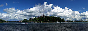 Vue panoramique du Château Boldt sur Heart Island | |
| Administration | |
|---|---|
| Pays |  États-Unis États-Unis |
| État |  New York New York |
| Chef-lieu | Watertown |
| Fondation | 1805 |
| Démographie | |
| Population | 116 721 hab. (2020) |
| Densité | 35 hab./km2 |
| Géographie | |
| Coordonnées | 43° 59′ nord, 76° 03′ ouest |
| Superficie | 329 400 ha = 3 294 km2 |
| Superficie eau | 151 600 ha = 1 516 km2 |
| Superficie totale | 481 000 ha = 4 810 km2 |
| Localisation | |
 Situation du comté dans l'État de New York. | |
modifier  | |
Le comté de Jefferson (en anglais : Jefferson County) est l'un des 62 comtés de l'État de New York, aux États-Unis. Le siège du comté est Watertown.
Municipalités
Villes
- Watertown
Communes
- Adams
- Alexandria
- Antwerp
- Brownville
- Cape Vincent
- Champion
- Clayton
- Ellisburg
- Henderson
- Hounsfield
- Le Ray
- Lorraine
- Lyme
- Orleans
- Pamelia
- Philadelphia
- Rodman
- Rutland
- Theresa
- Watertown
- Wilna
- Worth
Démographie
| Historique des recensements | |||
| Ann. | Pop. | %± | |
|---|---|---|---|
| 1810 | 15 140 | — | |
| 1820 | 32 952 | ▲ +117,65 % | |
| 1830 | 48 493 | ▲ +47,16 % | |
| 1840 | 60 984 | ▲ +25,76 % | |
| 1850 | 68 153 | ▲ +11,76 % | |
| 1860 | 69 825 | ▲ +2,45 % | |
| 1870 | 65 415 | ▼ −6,32 % | |
| 1880 | 66 103 | ▲ +1,05 % | |
| 1890 | 68 806 | ▲ +4,09 % | |
| 1900 | 76 748 | ▲ +11,54 % | |
| 1910 | 80 382 | ▲ +4,73 % | |
| 1920 | 82 250 | ▲ +2,32 % | |
| 1930 | 83 574 | ▲ +1,61 % | |
| 1940 | 84 003 | ▲ +0,51 % | |
| 1950 | 85 521 | ▲ +1,81 % | |
| 1960 | 87 835 | ▲ +2,71 % | |
| 1970 | 88 508 | ▲ +0,77 % | |
| 1980 | 88 151 | ▼ −0,4 % | |
| 1990 | 110 943 | ▲ +25,86 % | |
| 2000 | 111 738 | ▲ +0,72 % | |
| 2010 | 116 229 | ▲ +4,02 % | |
| 2020 | 116 721 | ▲ +0,42 % | |
La population du comté s'élevait à 116 721 habitants au recensement de 2020.
| Groupe | Comté de Jefferson | New York | États-Unis |
|---|---|---|---|
| Blancs | 88,7 | 66,8 | 72,4 |
| Afro-Américains | 5,1 | 15,9 | 12,6 |
| Métis | 2,8 | 3,0 | 2,9 |
| Autres | 1,4 | 7,4 | 6,2 |
| Asiatiques | 1,3 | 7,3 | 4,8 |
| Amérindiens | 0,5 | 0,6 | 0,9 |
| Océano-Américains | 0,3 | 0,1 | 0,2 |
| Total | 100 | 100 | 100 |
| Hispaniques et Latino-Américains | 5,3 | 17,6 | 16,7 |
Selon l'American Community Survey, en 2010 92,17 % de la population âgée de plus de 5 ans déclare parler l'anglais à la maison, 3,19 % déclare parler l'espagnol, 1 % l'allemand, 0,60 % le français et 3,04 % une autre langue[3].
Notes et références
Voir aussi
Lien externe
- (en) Site officiel
Municipalités et communautés du comté de Jefferson (New York) | ||
|---|---|---|
| Siège du comté |
|  |
| City |
| |
| Towns |
| |
| Villages |
| |
| Census-designated places |
| |
| ||
v · m Les 62 comtés de l’État de New York | ||
|---|---|---|
|  | |
 Portail de l’État de New York


