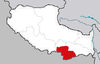
Zhanang County
County in Tibet, China
Zhanang County 29°27′54″N 91°36′40″E / 29.46500°N 91.61111°E / 29.46500; 91.61111 | |
|---|---|
| Country | China |
| Autonomous region | Tibet |
| Prefecture-level city | Shannan (Lhokha) |
| County seat | Dratang |
| Area | |
| • Total | 2,141.92 km2 (827.00 sq mi) |
| Population (2020)[1] | |
| • Total | 36,656 |
| • Density | 17/km2 (44/sq mi) |
| Time zone | UTC+8 (China Standard) |
| Website | www |
| Zhanang County | |||||||
|---|---|---|---|---|---|---|---|
| Chinese name | |||||||
| Simplified Chinese | 扎囊县 | ||||||
| Traditional Chinese | 扎囊縣 | ||||||
| |||||||
| Tibetan name | |||||||
| Tibetan | གྲ་ནང་རྫོང་། | ||||||
| |||||||
Zhanang County or Dranang (Tibetan: གྲ་ནང་རྫོང, Chinese: 扎囊县) is a county of Shannan (Lhokha) in the Tibet Autonomous Region, China. The capital town of county is Dratang town, with a monastery named Dratang.[2]
Dranang County is home to Samye Monastery, the first Buddhist monastery in Tibet, and many other monasteries, including Mindrolling Monastery.
Dranang County is separated into northern and southern parts by the Yarlung Tsangpo River. In 2015 a bridge near Dratang Town was finished, connecting the northern and southern parts of the county. Until 2015 there were regular rafts for transportation of people or small goods.
Administrative divisions
Dranang County contains 2 towns and 3 townships.
| Name | Chinese | Hanyu Pinyin | Tibetan | Wylie |
|---|---|---|---|---|
| Towns | ||||
| Dratang Town | 扎塘镇 | Zhātáng zhèn | གྲ་ཐང་གྲོང་རྡལ། | grang thang grong rdal |
| Samye Town | 桑耶镇 | Sāngyē zhèn | བསམ་ཡས་གྲོང་རྡལ། | bsam yas grong rdal |
| Townships | ||||
| Drachi Township | 扎其乡 | Zhāqí xiāng | གྲ་ཕྱི་ཤང་། | gra phyi shang |
| Ngadra Township | 阿扎乡 | Āzhā xiāng | ལྔ་གྲ་ཤང་། | lnga gra shang |
| Gyiru Township | 吉汝乡 | Jírǔ xiāng | དཀྱིལ་རུ་ཤང་། | dkyil ru shang |
Demographics
As of 2000 it had a population of 35,278.
| Ethnicity | Population | Percentage |
|---|---|---|
| Tibetan | 35.018 | 99,26% |
| Han | 235 | 0,67% |
| Hui | 8 | 0,02% |
| Miao | 5 | 0,01% |
| Tujia | 4 | 0,01% |
| Sonstige[clarification needed] | 8 | 0,02% |
Climate
| Climate data for Dranang (1981−2010) | |||||||||||||
|---|---|---|---|---|---|---|---|---|---|---|---|---|---|
| Month | Jan | Feb | Mar | Apr | May | Jun | Jul | Aug | Sep | Oct | Nov | Dec | Year |
| Mean daily maximum °C (°F) | 8.7 (47.7) | 10.7 (51.3) | 14.2 (57.6) | 17.3 (63.1) | 20.9 (69.6) | 24.1 (75.4) | 23.2 (73.8) | 22.0 (71.6) | 20.6 (69.1) | 17.9 (64.2) | 13.1 (55.6) | 9.2 (48.6) | 16.8 (62.3) |
| Daily mean °C (°F) | −0.6 (30.9) | 2.4 (36.3) | 6.4 (43.5) | 9.5 (49.1) | 13.3 (55.9) | 16.7 (62.1) | 16.4 (61.5) | 15.7 (60.3) | 13.9 (57.0) | 9.6 (49.3) | 3.2 (37.8) | −0.7 (30.7) | 8.8 (47.9) |
| Mean daily minimum °C (°F) | −8.2 (17.2) | −5.4 (22.3) | −1.4 (29.5) | 2.3 (36.1) | 6.3 (43.3) | 10.4 (50.7) | 11.3 (52.3) | 11.0 (51.8) | 9.0 (48.2) | 3.4 (38.1) | −4.2 (24.4) | −7.9 (17.8) | 2.2 (36.0) |
| Average precipitation mm (inches) | 0.4 (0.02) | 0.3 (0.01) | 1.6 (0.06) | 6.9 (0.27) | 20.3 (0.80) | 49.6 (1.95) | 119.4 (4.70) | 122.5 (4.82) | 66.4 (2.61) | 8.8 (0.35) | 0.4 (0.02) | 0.5 (0.02) | 397.1 (15.63) |
| Average relative humidity (%) | 35 | 29 | 30 | 38 | 44 | 51 | 63 | 67 | 64 | 51 | 43 | 43 | 47 |
| Source: Weather China[3] | |||||||||||||
Gallery
-
 Samye monastery
 -
 Black stupa of Samye
 -
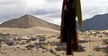 Near Samye monastery
 -
 Yarlung Tsangpo
 -
 Yarlung Tsangpo
 -
 Yarlung Tsangpo


References
- v
- t
- e
Lhasa (capital)
cities
| Lhasa | |
|---|---|
| Xigazê | |
| Qamdo | |
| Nyingchi | |
| Shannan | |
| Nagqu |
| Ngari |
|---|
** Southern portions of these counties are claimed by the People's Republic of China as part of the South Tibet area, but are administered by India.
Authority control databases | |
|---|---|
| International |
|
| National |
|
 | This Shannan, Tibet location article is a stub. You can help Wikipedia by expanding it. |
- v
- t
- e


