Yokohama Bay Bridge
Bridge in Yokohama, Kanagawa
35°27′18″N 139°40′27″E / 35.4551°N 139.6742°E / 35.4551; 139.6742
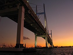
The Yokohama Bay Bridge (横浜ベイブリッジ, Yokohama Bei Buridji) is an 860 metres (2,820 ft) cable stayed bridge in Yokohama, Japan. Opened September 27, 1989, it crosses Tokyo Bay with a span of 460 metres (1,510 feet). The toll is ¥600. The bridge is part of the Bayshore Route of the Shuto Expressway.
Notes
- ^ a b "Yokohama Bay Bridge". Ministry of Land, Infrastructure, Transportation and Tourism (MLIT). Retrieved 2010-07-10.
External links
 Media related to Yokohama Bay Bridge at Wikimedia Commons
| Authority control databases: Geographic |
|
|---|
- v
- t
- e
 | This Kanagawa Prefecture location article is a stub. You can help Wikipedia by expanding it. |
- v
- t
- e


