Yeranos
Place in Gegharkunik, Armenia
Yeranos Երանոս | |
|---|---|
 Village entrance | |
40°12′15″N 45°11′18″E / 40.20417°N 45.18833°E / 40.20417; 45.18833 | |
| Country | Armenia |
| Province | Gegharkunik |
| Municipality | Martuni |
| Elevation | 2,007 m (6,585 ft) |
| Population (2011)[1] | |
| • Total | 5,479 |
| Time zone | UTC+4 (AMT) |
| Postal code | 1406 |
| Yeranos at GEOnet Names Server | |
Yeranos (Armenian: Երանոս) is a village in the Martuni Municipality of the Gegharkunik Province of Armenia.
History
The church of St. Astvatsatsin in the village dates back to 1215, and the village also contains Tukh Manuk and St. Sofia shrines. Following the Gavar-Martuni road, near the chicken farm, are the remains of a cyclopean fort.[2]
Gallery
-
 Chapel in Yeranos
 -
 St. Astvatsatsin Church in Yeranos
 -
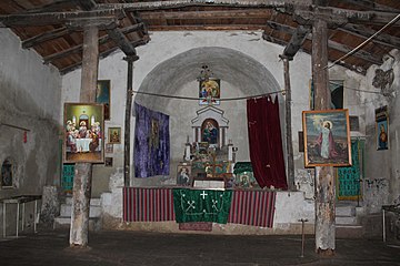 St. Astvatsatsin Church interior


References
- ^ Statistical Committee of Armenia. "The results of the 2011 Population Census of Armenia" (PDF).
- ^ Kiesling, Brady; Kojian, Raffi (2005). Rediscovering Armenia: Guide (2nd ed.). Yerevan: Matit Graphic Design Studio. pp. 78–79. ISBN 99941-0-121-8.
External links
Wikimedia Commons has media related to Yeranos, Gegharkunik.
- World Gazeteer: Armenia[dead link] – World-Gazetteer.com
- Report of the results of the 2001 Armenian Census, Statistical Committee of Armenia
- Kiesling, Brady (June 2000). Rediscovering Armenia: An Archaeological/Touristic Gazetteer and Map Set for the Historical Monuments of Armenia (PDF). Archived (PDF) from the original on 6 November 2021.
- v
- t
- e
 Gegharkunik Province
Capital: Gavar

- Akhpradzor
- Akunk
- Areguni
- Arpunk
- Avazan
- Ayrk
- Azat
- Daranak
- Geghakar
- Geghamabak
- Geghamasar
- Jaghatsadzor
- Kakhakn
- Karchaghbyur
- Khachaghbyur
- Kut
- Kutakan
- Lchavan
- Lusakunk
- Makenis
- Mets Masrik
- Nerkin Shorzha
- Norabak
- Norakert
- Pambak
- Pokr Masrik
- Shatjrek
- Shatvan
- Sotk
- Torfavan
- Tretuk
- Tsovak
- Vanevan
- Verin Shorzha
- Zariver
Portal:
 Geography

 | This article about a location in Gegharkunik Province, Armenia is a stub. You can help Wikipedia by expanding it. |
- v
- t
- e


