Westwoud
Village in North Holland, Netherlands

Flag

Coat of arms
(2019)[1]
1617
Westwoud is a village in the Netherlands. It is located in the region of West Friesland in North Holland, about 4 kilometers northeast of Hoorn. The town is part of the municipality of Drechterland and has a population of 1,785.
Westwoud received city rights in 1414, along with the villages of Westerblokker and Oosterblokker. This mainly meant it could form its own judicial district, which was abolished in 1811. [2] It was a separate municipality between 1817 and 1979, when it merged with Hoogkarspel and Oosterblokker to form the municipality Bangert, which was changed to Drechterland in 1980.[3]
Gallery
-
 Village center
 -
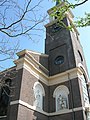 Saint Martin's Church
 -
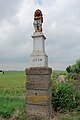 Historic border pole


References
- v
- t
- e
Populated places in the municipality of Drechterland
- Hem
- Hoogkarspel
- Oosterblokker
- Oosterleek
- Schellinkhout
- Venhuizen
- Westwoud
- Wijdenes
 | This North Holland location article is a stub. You can help Wikipedia by expanding it. |
- v
- t
- e


