Watergang
Village in North Holland, Netherlands
52°26′N 4°57′E / 52.433°N 4.950°E / 52.433; 4.950 (2021)[1]
1454[1]
Watergang (pronunciationⓘ, literally "watercourse") is a village in the northwest Netherlands. It is located in the municipality of Waterland, North Holland, about seven kilometres (four miles) north of Amsterdam, on the east bank of the Noordhollandsch Kanaal.
The village was first mentioned in 1343 as "van waterganghe", and means canal. It refers to the waterway between Monnickendam and Amsterdam.[3] The canal developed during the peat excavation of the 12th century, and Watergang developed as a linear settlement along the canal. The Dutch Reformed church dates from 1642 and was restored in 1832.[4]
People from Watergang
- Alexander Johan Berman, Dutch Reformed Minister of Watergang
- Simon Berman, Watergang-born mayor of Schagen, Bedum, and Alblasserdam
Gallery
-
 Watergang, church in the street
 -
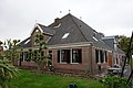 Farm in Watergang
 -
 Tree in Watergang


References
- ^ a b c "Kerncijfers wijken en buurten 2021". Central Bureau of Statistics. Retrieved 2 May 2022.
- ^ "Postcodetool for 1454AA". Actueel Hoogtebestand Nederland (in Dutch). Het Waterschapshuis. Retrieved 2 May 2022.
- ^ "Watergang - (geografische naam)". Etymologiebank (in Dutch). Retrieved 2 May 2022.
- ^ "Watergang". Plaatsengids (in Dutch). Retrieved 2 May 2022.
- v
- t
- e
Populated places in the municipality of Waterland
- Broek in Waterland
- Ilpendam
- Katwoude
- Marken
- Purmer (partially)
- Uitdam
- Watergang
- Zuiderwoude
Authority control databases | |
|---|---|
| International |
|
| National |
|
 | This North Holland location article is a stub. You can help Wikipedia by expanding it. |
- v
- t
- e


