Waputik Icefield
Glacier in Canada
The Waputik Icefield is located on the Continental divide in the Canadian Rocky Mountains, in the provinces of British Columbia and Alberta. It is developed on the heights of the Waputik Range in the Central Main Ranges.
The icefield is shared by Banff and Yoho National Parks and numerous outlet glaciers extend from the icefield. Runoff from the Waputik Icefield provides water for numerous lakes, streams and rivers including Hector Lake, and the Bow, Kicking Horse and Yoho Rivers. Runoff from the Daly Glacier feeds Takakkaw Falls.
The icefield encompasses 40 km2 (15 miles²) and is located 20 km (12 mi) northwest of Lake Louise, on the west side of the Icefields Parkway.
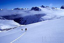
The icefield is easily accessible by mountaineers in both the summer and winter. Both ski trips in the winter and glacier hiking trips in the summer often combine a traverse of this icefield with a trip across the Wapta Icefield directly to the north.
Glaciers
The following glaciers are part of this icefield:
- Waputik Glacier
- Diableret Glacier
- Glacier des Poilus
- Emerald Glacier
- Bath Glacier
- Niles Glacier
- Balfour Glacier
- Daly Glacier
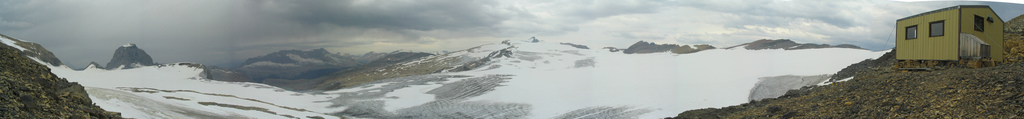
Huts
There are two huts operated by the Alpine Club of Canada which are accessible from this icefield:
See also
- List of glaciers
References
- Bivouac.com. "Waputik Icefield". Canadian Mountain Encyclopedia. Retrieved 2006-07-03.
External links
![]() Media related to Waputik Icefield at Wikimedia Commons
Media related to Waputik Icefield at Wikimedia Commons
- v
- t
- e
Canadian Rockies
- Ball
- Bare
- Beaverfoot
- Blue
- Bow
- Crowsnest
- Elk
- Fairholme
- Fiddle
- Flathead
- Foothills
- High Rock
- Kananaskis
- Livingstone
- Lizard
- Maligne
- Massive
- Misty
- Morrissey
- Palliser
- President
- Queen Elizabeth
- Rainbow
- Ram
- Sawback
- Sentinel
- Slate
- South Jasper
- Sundance
- Terminal
- Tower of London
- Vermilion
- Victoria Cross
- Waputik
- Winston Churchill
- Continental Ranges
- Hart Ranges
- Muskwa Ranges
- Alberta
- Andromeda
- Assiniboine
- Athabasca
- Brazeau
- Bryce
- Cascade
- Castle
- Castleguard
- Clemenceau
- Columbia
- Cory
- Edith Cavell
- Forbes
- Hector
- Hosmer
- Hungabee
- Joffre
- Kitchener
- Lyell
- Heart
- Pilot
- Pyramid
- Resplendent
- Robson
- Rundle
- Sarbach
- Saskatchewan
- Smythe
- Snow Dome
- Stanley Peak
- Sulphur
- Temple
- Three Sisters
- Trinity
- Twin
- Ulysses
- Unnamed Alberta–BC mountain (formerly Mount Pétain)
- Whymper
- Athabasca
- Bow
- Columbia Icefield
- Crowfoot
- Hector
- Peyto
- Saskatchewan
- Vulture
- Wapta
- Waputik Icefield
see List of rivers of the Canadian Rockies and Category:Rivers of the Canadian Rockies
- Mountain Stoney
- Mountain Metis
| International | |
|---|---|
| National |
|
| Provincial (AB) |
|
| Provincial (BC) |
- See also
- Geography portal
- Canada portal
| Authority control databases: National |
|
|---|
51°34′N 116°27′W / 51.567°N 116.450°W / 51.567; -116.450
 | This article about a location in the Interior of British Columbia, Canada is a stub. You can help Wikipedia by expanding it. |
- v
- t
- e

 | This Alberta's Rockies location article is a stub. You can help Wikipedia by expanding it. |
- v
- t
- e


