Upper Grindelwald Glacier
46°36′48″N 8°6′26″E / 46.61333°N 8.10722°E / 46.61333; 8.10722Length 6 km 
Mountains Glaciers
Lakes
The Upper Grindelwald Glacier (German: Oberer Grindelwaldgletscher) is one of the two valley glaciers near Grindelwald on the northern side of the Bernese Alps, in the canton of Bern (the other being the Lower Grindelwald Glacier). It had a length of about 6.6 km (4.1 mi) and covered an area of 9.6 km2 (3.7 sq mi) in 1973.
The Upper Grindelwald Glacier arises from a vast snow field north of the Schreckhorn and south of the Wetterhorn. The glacier tongue is currently[when?] at around 1,400 metres (4,600 ft) above sea level, making it one of the lowest glaciers in the Alps.
-
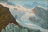 Upper Grindelwald Glacier c. 1870/80. Etching by Heinrich Müller

See also
- List of glaciers in Switzerland
- List of glaciers
- Retreat of glaciers since 1850
- Swiss Alps
External links
- Swiss glacier monitoring network
- v
- t
- e
Jungfrau-Aletsch (World Heritage Site)
- Finsteraarhorn
- Aletschhorn
- Jungfrau
- Mönch
- Schreckhorn
- Lauteraarhorn
- Grosses Fiescherhorn
- Hinteres Fiescherhorn
- Grünhorn
- Gletscherhorn
- Eiger
- Ebnefluh
- Bietschhorn
- Grosses Wannenhorn
- Mittaghorn
- Nesthorn
- Wetterhorn
- Blüemlisalp
| North side |
|
|---|---|
| South side |
| Authority control databases |
|
|---|
 | This article about a glacier in the canton of Bern is a stub. You can help Wikipedia by expanding it. |
- v
- t
- e


