Tyburnia
Area in Central London

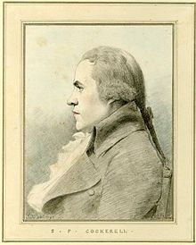
Tyburnia, a part of Paddington in London, originally developed following an 1824 masterplan drawn up by Samuel Pepys Cockerell (1753–1827) to redevelop the historic lands of the Bishop of London, known as the Tyburn Estate, into a residential area to rival Belgravia. Tyburnia was the first part of Paddington to be developed.[1]
Area
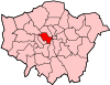
The area called Tyburnia has varied over time and it was never finished according to the original plan but it is certainly bounded by Edgware Road in the east and Bayswater Road and Hyde Park Place in the south. The northern boundary is generally regarded as Craven Road and Praed Street, while the western boundary is generally regarded as Gloucester Terrace. Sussex Gardens provides the main axis of the area, off which other streets run.[2] It features several garden squares including Norfolk Square, Talbot Square, Hyde Park Square and Sussex Square. Streets include Albion Street, Stanhope Terrace, Connaught Street and Connaught Place. St George's Fields is also located in the area.
History

The district formed the centrepiece of an 1824 masterplan by Samuel Pepys Cockerell to redevelop the historic lands of the Bishop of London, known as the Tyburn Estate,[3] into a residential area to rival Belgravia.[4] It was the first part of Paddington to be developed.[5]
The area was laid out in the mid-1800s when grand squares and cream-stuccoed terraces started to fill the acres between Paddington station and Hyde Park; however, the plans were never realised in full. The author William Makepeace Thackeray, who lived in Albion Street, described the district as "the elegant, the prosperous, the polite Tyburnia, the most respectable district of the habitable globe."[6]
References
- ^ Robins, William (1853). Paddington: past and present. p. 195. Retrieved 8 January 2023.
The transition-state from an agricultural village to the fashionable Tyburnia, was no very agreeable time for the majority of those who lived in Paddington.
- ^ Cherry, Bridget & Pevsner, Nikolaus. London 3: North West. Yale University Press, 2002. p.684
- ^ "Tyburnia – A History of the Paddington Estates". Hyde Park Square Garden. 20 October 2014. Retrieved 11 June 2017.
- ^ Walford, Edward. "Tyburn and Tyburnia". Old and New London: Volume 5. British History Online. Retrieved 11 June 2017.
- ^ T. F. T. Baker, Diane K. Bolton and Patricia E. C. Croot (1989). "'Paddington: Tyburnia' in A History of the County of Middlesex: Volume 9, Hampstead, Paddington". British History Online. pp. 190–198. Retrieved 11 June 2017.
- ^ Brewer, E. Cobham. "Brewer's Dictionary of Phrase and Fable (1898)". Bartleby.com. Retrieved 11 June 2017.
External links
![]() Media related to Tyburnia at Wikimedia Commons
Media related to Tyburnia at Wikimedia Commons
- v
- t
- e
- Adelphi and Aldwych (see also Strand)
- Bayswater
- Belgravia
- Clare Market
- Covent Garden
- Fitzrovia
- Hyde Park (in commercial use)
- Kilburn
- Knightsbridge
- Lisson Grove
- Maida Vale
- including Little Venice
- Marylebone
- Mayfair
- Millbank
- Paddington
- including Paddington Green and Tyburnia
- Pimlico
- Queen's Park
- St James's
- St John's Wood
- Soho
- including Chinatown
- Victoria
- Westbourne Green
- Westminster
- Apsley House
- Banqueting House
- Benjamin Franklin House
- British Dental Association Museum
- British Optical Association Museum
- Buckingham Palace
- Canada House Gallery
- Churchill War Rooms
- Clarence House
- Courtauld Gallery
- Crime Museum
- Faraday Museum
- Fleming Museum
- Guards Museum
- Handel & Hendrix
- Horse Guards
- Household Cavalry Museum
- Hunterian Museum
- Institute of Contemporary Arts
- Kennel Club Dog Art Gallery
- London Film Museum
- London Transport Museum
- Madame Tussauds
- Mall Galleries
- National Gallery
- Palace of Westminster
- Queen's Gallery
- Royal Academy of Arts
- Royal Academy of Music Museum
- Royal Mews
- Sherlock Holmes Museum
- Somerset House
- Spencer House
- Tate Britain
- Trafalgar Square
- Twinings Museum
- Two Temple Place
- Wallace Collection
- Wellington Arch
- West End theatre
- Westminster Abbey
- London Zoo
- Cities of London and Westminster
- Westminster North


 Baker Street
-
 Bayswater
 Bond Street
 Charing Cross
-
 Charing Cross
 - Edgware Road
- Edgware Road
- Embankment
- Great Portland Street
-

 Green Park
 - Hyde Park Corner
- Lancaster Gate
- Leicester Square
- Maida Vale
- Marble Arch
- Marylebone
- Oxford Circus
- Paddington
- Paddington
- Paddington
- Piccadilly Circus
- Pimlico
- Queensway
- Regent's Park
- Royal Oak
- St James's Park
- St John's Wood
- Temple
- Tottenham Court Road
- Victoria
- Warwick Avenue
- Westbourne Park
- Westminster


- Grade I listed buildings
- Grade II* listed buildings
- 1–9
- A–Z
- Public art
 Category

51°30′54″N 0°10′12″W / 51.5149°N 0.1701°W / 51.5149; -0.1701
 | This London location article is a stub. You can help Wikipedia by expanding it. |
- v
- t
- e


