Taimali
Rural township in Taitung County, Taiwan
Rural township
Taimali Township 太麻里鄉 Tamari | |
|---|---|
Rural township | |
 | |
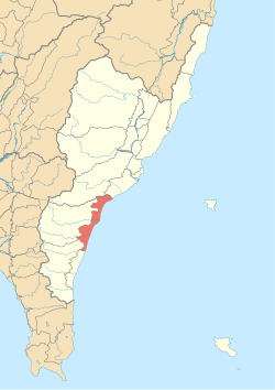 Taimali Township in Taitung County | |
| Location | Taitung County, Taiwan |
| Area | |
| • Total | 97 km2 (37 sq mi) |
| Population (September 2023) | |
| • Total | 10,723 |
| • Density | 110/km2 (290/sq mi) |
Taimali Township (Chinese: 太麻里鄉; pinyin: Tàimálǐ Xiāng) is a rural township in Taitung County, Taiwan. It has a population of 10,763 in 96.6523 km2 area. Taimali Township is located on the Pacific coast.[1] The indigenous Amis and Paiwan peoples make up one-third of the population.
History
Tjavualji was established 1,000 years ago by the Qian YaoKao, also called the Da Ma, who were ancestors of the Paiwan people. Qing era records show the placename written variously (Chinese: 兆貓裡/朝貓籬/大貓狸/大麻里), etc.[2] According to Paiwan legend it had been called "the village of sunrise" (Jabauli or Tjavualji in Paiwan language) because there the sun rises from the eastern sea.


In the early 1900s (under Japanese rule), the Amis and additional Paiwan were moved to the village. In 1920, the village was officially called Tamari (太麻里), which is essentially the name used up to now. During the 1940s (also under Japanese rule), some residents from Miaoli, Nantou, Changhua, Yunlin, Chiayi, Tainan, Kaohsiung, and Pingtung also settled in the area. Due to the increasing population, the Japanese government subordinated the village to Taitō District, Taitō Prefecture, and in 1937, its official name was changed to Tamari Village (太麻里庄).

After Taiwan was handed over from Japan to the Republic of China in 1945, its name was modified to Taimali Village (太麻里村).
Administrative divisions
The township comprises nine villages: Beili, Dawang, Duoliang, Huayuan, Jinlun, Meihe, Sanhe, Taihe and Xianglan.
Tourist attractions
- Duoliang Station
- Aboriginal People Ancestor's Birthplace Stele
- Fushan Park
- Jinjhen Mountain Agriculture Areas
- Kimlun Hot Springs Scenic Areas
- Millennium Dawn Commemorate Parks
- Sanho Waterfront Park
Transportation

- TRA - South-link line
- Provincial Highway 9
- Jinlun Bridge
References
Wikimedia Commons has media related to Taimali Township, Taitung County.
- v
- t
- e
Cities and townships of Taitung County

Taiwanese Indigenous Areas | ||||||||||||||||||||||||||
|---|---|---|---|---|---|---|---|---|---|---|---|---|---|---|---|---|---|---|---|---|---|---|---|---|---|---|
| Highland indigenous Townships and Districts |
| 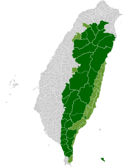 | ||||||||||||||||||||||||
| Plains indigenous Townships and County-Administered Cities |
| |||||||||||||||||||||||||
Note: On the map, "Mountain Indigenous Areas" are in dark green and "Plains Indigenous Areas" are in light green. | ||||||||||||||||||||||||||
| Authority control databases: Geographic |
|
|---|
22°37′N 121°00′E / 22.617°N 121.000°E / 22.617; 121.000


