Téglás
Town in Hajdú-Bihar, Hungary

Flag

Coat of arms
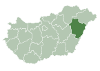
 Hungary
 (2015)
4243
Téglás is a town in Hajdú-Bihar county, in the Northern Great Plain region of eastern Hungary.
Geography
It covers an area of 38.33 km2 (15 sq mi) and has a population of 6406 people (2015).[1] Téglás also is accessible to Debrecen to the south and Nyíregyháza to the north. As well as those two locations, you could head west towards Balkány.[2]
Sports
Téglás has a soccer team called Téglas VSE.[3]
International relations
Twin towns – Sister cities
Téglás is twinned with:
 Affalterbach, Germany
 Fulnek, Czech Republic
 Ludwin, Poland


References
External links
Wikimedia Commons has media related to Téglás.
- Official website in Hungarian

| ||
|---|---|---|
| City with county rights |
|   |
| Towns | ||
| Large villages | ||
| Villages |
| |
| Other topics |
| |
 | This Hajdú-Bihar location article is a stub. You can help Wikipedia by expanding it. |
- v
- t
- e


