Szanda
Place in Nógrád, Hungary
47°55′37″N 19°26′18″E / 47.92689°N 19.43844°E / 47.92689; 19.43844 Hungary
 (2004)
2697
Szanda is a village in Nógrád county, Hungary.
-

-

-

-
-

-
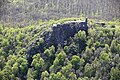
 Aerial photography of a castle in Szanda


External links
- Street map (in Hungarian)
- Aerial Photographs
- v
- t
- e
- Salgótarján (county seat)


- Balassagyarmat
- Bátonyterenye
- Pásztó
- Rétság
- Szécsény
- Alsópetény
- Alsótold
- Bánk
- Bárna
- Becske
- Bercel
- Berkenye
- Bér
- Bokor
- Borsosberény
- Buják
- Cered
- Cserháthaláp
- Cserhátsurány
- Cserhátszentiván
- Csesztve
- Csécse
- Csitár
- Debercsény
- Dejtár
- Diósjenő
- Dorogháza
- Drégelypalánk
- Ecseg
- Egyházasdengeleg
- Egyházasgerge
- Endrefalva
- Erdőkürt
- Erdőtarcsa
- Etes
- Érsekvadkert
- Felsőpetény
- Felsőtold
- Galgaguta
- Garáb
- Herencsény
- Héhalom
- Hollókő
- Hont
- Horpács
- Hugyag
- Iliny
- Ipolyszög
- Ipolytarnóc
- Ipolyvece
- Jobbágyi
- Karancsalja
- Karancsberény
- Karancskeszi
- Karancslapujtő
- Karancsság
- Kazár
- Kálló
- Keszeg
- Kétbodony
- Kisbágyon
- Kisbárkány
- Kisecset
- Kishartyán
- Kozárd
- Kutasó
- Legénd
- Litke
- Lucfalva
- Ludányhalászi
- Magyargéc
- Magyarnándor
- Márkháza
- Mátramindszent
- Mátranovák
- Mátraszele
- Mátraszőlős
- Mátraterenye
- Mátraverebély
- Mihálygerge
- Mohora
- Nagybárkány
- Nagykeresztúr
- Nagylóc
- Nagyoroszi
- Nemti
- Nézsa
- Nógrád
- Nógrádkövesd
- Nógrádmarcal
- Nógrádmegyer
- Nógrádsáp
- Nógrádsipek
- Nógrádszakál
- Nőtincs
- Őrhalom
- Ősagárd
- Palotás
- Patak
- Patvarc
- Piliny
- Pusztaberki
- Rákóczibánya
- Rimóc
- Romhány
- Ságújfalu
- Sámsonháza
- Somoskőújfalu
- Sóshartyán
- Szalmatercs
- Szanda
- Szarvasgede
- Szátok
- Szendehely
- Szente
- Szécsénke
- Szécsényfelfalu
- Szilaspogony
- Szirák
- Szuha
- Szurdokpüspöki
- Szügy
- Tar
- Terény
- Tereske
- Tolmács
- Vanyarc
- Varsány
- Vizslás
- Zabar
- History
- Geography
- Government
- Economy
- Culture
- Tourism
 | This Nógrád county location article is a stub. You can help Wikipedia by expanding it. |
- v
- t
- e


