State College–DuBois, PA Combined Statistical Area
Combined statistical area in Pennsylvania, United States
State College–DuBois, PA CSA | |
|---|---|
Combined statistical area | |
 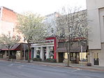 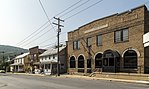 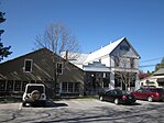 Clockwise from top left: State College, DuBois, Boalsburg, and Port Matilda | |
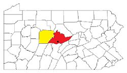 Map of the State College–DuBois, PA Combined Statistical Area (CSA), composed of the following parts: | |
| Country |  United States United States |
| State |  Pennsylvania Pennsylvania |
| Principal cities | State College, DuBois, Bellefonte, Boalsburg |
| Elevation | 351 m (1,154 ft) |
| Population (2010) | |
| • Metro | CSA: 236,577 (124th)[1] |
| Time zone | UTC-5 (EST) |
| • Summer (DST) | UTC-4 (EST) |
The State College–DuBois, PA Combined Statistical Area (CSA) is made up of two counties in central Pennsylvania. The United States Office of Management and Budget[2] recognized the State College and DuBois areas along with the counties of Centre and Clearfield as a combined statistical area (CSA) in Central Pennsylvania.
As of the 2010 United States census,[3] the CSA had a population total of 235,632, ranking the ninth most populous in Pennsylvania and 123rd most populous in the United States.
Component metropolitan areas
State College, PA Metropolitan Statistical Area
- Centre County population 155,171
Cities/major boroughs
- Bellefonte
- Boalsburg
- Ferguson Township – home rule municipality
- Park Forest Village
- Philipsburg
- State College – home rule municipality
DuBois, PA Micropolitan Statistical Area
- Clearfield County population 81,642
Cities/major boroughs
See also
References
- v
- t
- e
Commonwealth of Pennsylvania
Harrisburg (capital)
- Outline
- Delegations
- Government
- History
- Geography
- Geology
- Law
- Notable Pennsylvanians
- State parks
- Symbols
- Tourist attractions
municipalities
- Abington Township
- Bensalem Township
- Bethel Park
- Bristol Township
- Cheltenham Township
- Cranberry Township
- Darby
- Falls Township
- Hampden Township
- Haverford Township
- Hempfield Township
- Lower Macungie Township
- Lower Makefield Township
- Lower Merion Township
- Lower Paxton Township
- Manheim Township
- McCandless
- Middletown Township
- Millcreek Township
- Monroeville
- Mt. Lebanon
- Norristown
- Northampton Township
- North Huntingdon Township
- Penn Hills
- Radnor Township
- Ridley Township
- Ross Township
- Shaler Township
- Spring Township
- State College
- Tredyffrin Township
- Upper Darby Township
- Upper Merion Township
- Warminster Township
- West Chester
- Whitehall Township
- York Township
- Allegheny Mountains
- Allegheny National Forest
- Allegheny Plateau
- Bald Eagle Valley
- Blue Ridge
- Coal Region
- Cumberland Valley
- Delaware Valley
- Dutch Country
- Endless Mountains
- Great Valley
- Happy Valley
- Laurel Highlands
- Lebanon Valley
- Lehigh Valley
- Mahoning Valley
- Main Line
- Nittany Valley
- Northeastern
- Northern Tier
- North Central
- North Penn Valley
- Ohio Valley
- Oil Region
- Oley Valley
- Pennsylvania Highlands
- Pennsylvania Wilds
- Penns Valley
- Piedmont
- Pocono Mountains
- Ridge and Valley
- South Central
- Susquehanna Valley
- Western
- Wyoming Valley
- Adams
- Allegheny
- Armstrong
- Beaver
- Bedford
- Berks
- Blair
- Bradford
- Bucks
- Butler
- Cambria
- Cameron
- Carbon
- Centre
- Chester
- Clarion
- Clearfield
- Clinton
- Columbia
- Crawford
- Cumberland
- Dauphin
- Delaware
- Elk
- Erie
- Fayette
- Forest
- Franklin
- Fulton
- Greene
- Huntingdon
- Indiana
- Jefferson
- Juniata
- Lackawanna
- Lancaster
- Lawrence
- Lebanon
- Lehigh
- Luzerne
- Lycoming
- McKean
- Mercer
- Mifflin
- Monroe
- Montgomery
- Montour
- Northampton
- Northumberland
- Perry
- Philadelphia
- Pike
- Potter
- Schuylkill
- Snyder
- Somerset
- Sullivan
- Susquehanna
- Tioga
- Union
- Venango
- Warren
- Washington
- Wayne
- Westmoreland
- Wyoming
- York
 Pennsylvania portal
41°00′N 78°15′W / 41.000°N 78.250°W / 41.000; -78.250


