Staffelsee
Lake in Garmisch-Partenkirchen, Bavaria, Germany
You can help expand this article with text translated from the corresponding article in German. (October 2012) Click [show] for important translation instructions.
- View a machine-translated version of the German article.
- Machine translation, like DeepL or Google Translate, is a useful starting point for translations, but translators must revise errors as necessary and confirm that the translation is accurate, rather than simply copy-pasting machine-translated text into the English Wikipedia.
- Consider adding a topic to this template: there are already 9,155 articles in the main category, and specifying
|topic=will aid in categorization. - Do not translate text that appears unreliable or low-quality. If possible, verify the text with references provided in the foreign-language article.
- You must provide copyright attribution in the edit summary accompanying your translation by providing an interlanguage link to the source of your translation. A model attribution edit summary is
Content in this edit is translated from the existing German Wikipedia article at [[:de:Staffelsee]]; see its history for attribution. - You may also add the template
{{Translated|de|Staffelsee}}to the talk page. - For more guidance, see Wikipedia:Translation.
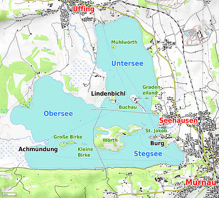
The Staffelsee is a lake in the Garmisch-Partenkirchen district of Bavaria, Germany. The settlements of Murnau, Seehausen and Uffing lie on its shores. Within its 7 km2 (2.7 sq mi) area lie seven islands, the largest and only inhabited of which is Wörth. Wörth was the site of Staffelsee abbey [de], a Carolingian monastery founded in the 8th century and dissolved in the 11th century.
Boat trips aboard the MS Seehausen (built 2009) connect the landing stages of Seehausen, Uffing and Achele (Murnau) between April and October.[3] The surface of the lake is, on average, 649 metres (2,129 ft) above sea level,[2] and at its deepest it is around 40 metres (130 ft) deep.[1]
The main inflow and outflow of the lake is the River Ach, which enters from the west and departs to the north.[2]
The northeastern part of the lake is known as Untersee, the southeastern part as Stegsee and the southwestern part as Obersee (see map below).
References
- ^ a b c d e f g h i "Dokumentation von Zustand und Entwicklung der wichtigsten Seen Deutschlands: Teil 11 Bayern" (PDF) (in German). Retrieved 22 October 2012.
- ^ a b c BY 7: Ammergebirge Ost, Pürschling. Hörnle (Map). 1:25000. Alpenvereinskarte Bayerische Alpen. Deutscher Alpenverein. 2009.
- ^ a b "Schiffart auf dem Staffelsee". Retrieved 22 October 2012.
- v
- t
- e
Authority control databases | |
|---|---|
| International |
|
| National |
|


